Recent Aerial View of Fukushima Nuke Plant
The photos were taken on February 10, 2013, from a Kyodo News helicopter at an altitude of 1,500 meters. For the first time, the government allowed the aerial photographs within 3 kilometers of Fukushima I Nuclear Power Plant as long as the altitude is 1,500 meters.
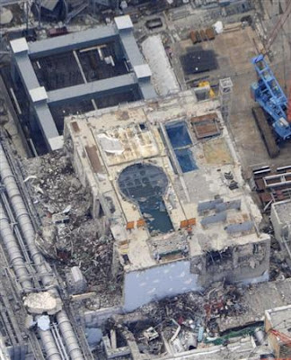
Reactor 4 building, with the steel frame being built (upper left) to suspend the crane for the removal of spent fuel in the future. The blue keyhole shape is the reactor well. The Spent Fuel Pool is covered with steel sheet:

Storage tanks for treated water taking up the available space at the plant:
At the end of the article, Sankei says that at about 3 kilometer south of the plant at an altitude of 500 meters the radiation level inside the helicopter was 2.5 microsieverts/hour, but the radiation level inside the 3-kilometer radius at an altitude of 1,500 meters hardly registered at all.
http://ex-skf.blogspot.com/2013/02/recent-aerial-view-of-fukushima-i-nuke.html