Welcome to DU!
The truly grassroots left-of-center political community where regular people, not algorithms, drive the discussions and set the standards.
Join the community:
Create a free account
Support DU (and get rid of ads!):
Become a Star Member
Latest Breaking News
General Discussion
The DU Lounge
All Forums
Issue Forums
Culture Forums
Alliance Forums
Region Forums
Support Forums
Help & Search
Environment & Energy
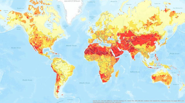
Related: About this forumAn Incredibly Detailed Map Shows The Potential Of Global Water Risks
Aqueduct, a new tool from the World Resources Institute, lets you see all the bad things that might stem from water, from droughts to floods and beyond.
Remember the drought that hit the U.S. in 2012? It was a big deal, even if it didn’t personally affect you. In fact, 53% of the country was dealing with what the USDA calls "moderate to extreme drought" by July. Over 1,000 counties were declared federal disaster areas.
Aqueduct, a new map from the World Resources Institute (WRI), throws the world’s growing water woes into stark relief. "We’re seeing that water and the lack of it is emerging as one of the defining challenges of the 21st century. What’s interesting now is that we’re hearing that concern echoed in the business community and across the world," says Betsy Otto, Director of Aqueduct for WRI.
The project, created with an alliance of companies including GE, Goldman Sachs, Shell, and Procter & Gamble, is the highest high-resolution map of global water stress available today. It’s also the first water-risk mapping tool to include a layer for groundwater data. WRI’s free map uses 2010 data (the most current data available) to measure a number of categories of water risk around the world: physical risk; variability in available water from year to year, which looks at flood occurrences (how often and how intense); severity of droughts (how long and how severe), groundwater stress, pollution pressure, demand for water treatment, media coverage about water issues (meaning how much attention is given to water in a given area), and more.
Otto discovered a number of striking things while putting together the map. Places that haven’t traditionally had high water risks--the East Coast of the United States, the upper Midwest, Europe--now have medium to high water risk. This is because of changes in water demand, withdrawal patterns, weather, and water-supply patterns. At the same time, places where there’s already high competition for water (i.e. India) are at serious risk when combined with annual variability in water. "When thinking about resilience in the face of risk, it’s not just baseline stress, but what the disruptions are that could really wreak havoc," explains Otto.
http://www.fastcoexist.com/1681298/an-incredibly-detailed-map-shows-the-potential-of-global-water-risks
Check the map out here. It has projected changes in water stress for 2025,2050 and 2095 plus many other tools.
http://aqueduct.wri.org/atlas
InfoView thread info, including edit history
TrashPut this thread in your Trash Can (My DU » Trash Can)
BookmarkAdd this thread to your Bookmarks (My DU » Bookmarks)
5 replies, 2019 views
ShareGet links to this post and/or share on social media
AlertAlert this post for a rule violation
PowersThere are no powers you can use on this post
EditCannot edit other people's posts
ReplyReply to this post
EditCannot edit other people's posts
Rec (7)
ReplyReply to this post
5 replies
 = new reply since forum marked as read
Highlight:
NoneDon't highlight anything
5 newestHighlight 5 most recent replies
= new reply since forum marked as read
Highlight:
NoneDon't highlight anything
5 newestHighlight 5 most recent replies
= new reply since forum marked as read
Highlight:
NoneDon't highlight anything
5 newestHighlight 5 most recent replies
An Incredibly Detailed Map Shows The Potential Of Global Water Risks (Original Post)
octoberlib
Feb 2013
OP

patrice
(47,992 posts)1. K&R
patrice
(47,992 posts)2. I think this shows why the world ought to be interested in Africa.
It's the worst with the least organizational and financial resources to respond to the situation.

dixiegrrrrl
(60,010 posts)3. Also shows that corporations are in the lead in targeting water resources.
"The project, created with an alliance of companies including GE, Goldman Sachs, Shell, and Procter & Gamble, "
patrice
(47,992 posts)4. Yes! And I suspect that they have been working on all of this for at least 3 decades.
The very first time I encountered the word "ecological" was in the KC Star, an article about a guy, a statistician I believe, not a meteorologist, living in Texas (sorry I can't remember his name) who was consulting with the Fortune 500 on these issues. The regional descriptions, as I recall them, were similar to what we are seeing on these new maps.
I have also seen it around here that there is a geopolitical pattern to the Koch's domestic activities that centers around the Great Lakes.

stuntcat
(12,022 posts)5. The Bushes' purchase in Paraguay:
http://www.guardian.co.uk/world/2006/oct/23/mainsection.tomphillips
"Some have speculated that he might be trying to wrestle control of the Guarani Aquifer, one of the largest underground water reserves, from the Paraguayans."
"Some have speculated that he might be trying to wrestle control of the Guarani Aquifer, one of the largest underground water reserves, from the Paraguayans."