Environment & Energy
Related: About this forumMeteorological group says Calif.s Death Valley set all-time heat record, is planets hot spot
By Associated Press, Updated: Friday, September 14, 3:00 PM
DEATH VALLEY, Calif. — California’s Death Valley has racked up another extreme accolade — it’s now deemed the world’s hottest place.
Long known as the lowest, driest and hottest spot in the United States, Death Valley this week was named as the hottest place on the globe by the World Meteorological Organization.
An international team of weather experts said the title comes after it investigated a long-held record from El Azizia, Libya, and found that an inexperienced weather observer recorded the temperature incorrectly.
The Libyan record was logged as 136.4 degrees on Sept. 13, 1922 — 90 years ago Thursday. It was set after the observer broke a more reliable instrument and used a complicated and less reliable type of thermometer, experts said. They believe the temperature was off by about 5 degrees ...
www.washingtonpost.com/national/meteorological-group-says-califs-death-valley-set-all-time-heat-record-is-planets-hot-spot/2012/09/14/a3e26536-fe74-11e1-98c6-ec0a0a93f8eb_story.html
 = new reply since forum marked as read
Highlight:
NoneDon't highlight anything
5 newestHighlight 5 most recent replies
= new reply since forum marked as read
Highlight:
NoneDon't highlight anything
5 newestHighlight 5 most recent replies

madokie
(51,076 posts)kestrel91316
(51,666 posts)
struggle4progress
(118,338 posts)Water plays a major role in heat transfer in the atmosphere, and (in particular) the presence of water can buffer air temperature
The reason is simple: evaporating water takes a lot of heat, and condensing water releases a lot of heat. So in very dry places, where you won't evaporate any water by day and won't condense any by night, daily summer temperature may easily swing from 50s at night to 120s in the day. But if the ground is moist near the surface over a large region, then daytime highs will be lower and nighttime lows will be higher
Death Valley is so dry partly because of the mountains: any moisture coming from the coast first has to get past the Sierra Nevada, but that big elevation climb forces clouds to cool and precipitate
madokie
(51,076 posts)happyslug
(14,779 posts)Last edited Mon Sep 17, 2012, 01:22 AM - Edit history (1)
1. Both areas are BELOW sea level.
2. No flow of water over both areas. Southern California is dry due to how the ocean currents flow. The North Pacific Current flows EAST to Washington State Oregon Northern California. The Current then turns south and West to Japan.
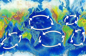
http://en.wikipedia.org/wiki/Ocean_gyre
As you can see the current goes in a circle. The Current brings water to the Northwest AND then DRAWS moisture from the Southwest. This is the Second reason the Death Valley is so dry.
The Atacama Desert in Chile is the result of a similar flow but the result of the draw due to the SOUTH PACIFIC CURRENT.
The Sahara desert is the result of a similar current draw. in fact the number source of new soil for the Amazon is the Sahara Desert.
Now the Libyan Desert in question s actually to far EAST to be affected by the Atlantic Current but it is also to far south to be affected by anything to its north or south thus it is desert AND next to the Qattara Depression which is even more below sea level then Death Valley.
Please note no one measure temperature in the actual Qattara Depression it is to isolated and hot.
Just some of the reason WHY these are two of the places with the highest temperatures
3. The effect of the POLAR Jet Stream do NOT affect either areas. The Polar Jet Stream is what pushes weather West to East, it varies but generally goes from about San Francisco to British Columbia Eastward, over then down along the Rockies, then back up along the Appalachians then up and down roughly the same latitudes worldwide. This helps moves weather West to East in Tempered climates.
The Polar Jet Stream rarely dips down to Death Valley area, the mountains to the North tend to direct it further East (The Jet Stream is much higher the the mountains, but the mountains act as a base that air below the Jet Stream can not go to, thus forcing that air elsewhere, and the same with the Jet Stream, it dips down to Texas for the Plains are flat, but then goes back up to Pennsylvania/New York State then it climbs over the Mountains. The Jet Stream does NOT want to go into the Tropics, so rarely (if ever) goes as far south as Gulf of Mexico, but it then acts as a pull to draw moisture from the Gulf into Texas and the Great Plains as while as the American South and Midwest east of the Mississippi River.
More on the Jet Streams:
http://en.wikipedia.org/wiki/Jet_stream
Please note there are FOUR Jet Streams, the Two Strongest are the Northern Polar Jet Stream mentioned above and the Southern Polar Jet Stream that helps keep Antarctica isolated from the rest of the Planet's weather. Closer to the Equator are two weaker Jet Streams. The affect of these two weaker Jet Streams is tied in with a forth factor, the "Inter-tropical Convergence Zone" or the "Doldrums".
http://en.wikipedia.org/wiki/Intertropical_Convergence_Zone
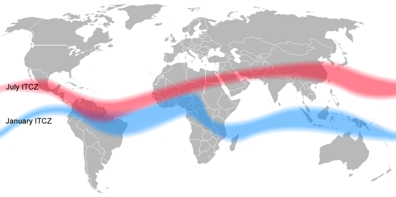
The Tropical Jet Streams come out of the Doldrums, but the Doldrums themselves are noted for lack of wind AND lack of weather movement. i.e. Weather tends to stay local, no cold fronts, no warm fronts, Weather stays local. Over land, the Doldrums are areas of some of the driest Deserts in the world. AS you can see in the map of the Doldrums, in the Summer it goes from Mexico, to Columbia, to the Gold Coast of Africa (Nigeria), to Libya, Saudi Arabia, Pakistan and China. If these areas have water, Agriculture survives, Thus Columbia getting water from Mountains and the current from Africa is wet in the Northern Summer, Libya, Egypt and Saudi Arabia tends to be dry in the Northern Summer AND the Northern Winter. China tends to be dry in the Northern Summer, except it also gets water from the Pacific Current which flows NORTHWARD dumping water on China, Korea and Japan. To far West (Mongolia for example) Asia starts to dry out in the Summer, gets water from the Northern Jet Stream in the Winter.
Libya and Death Valley, tends to be affected by the Doldrums with a lack of water and once an area in the Doldrums have no water it stays that way.
4. The Monsoons. Presently only two Monsoons are recognized, the West African and Asia/Australia Monsoons. There is some evidence to support a North American and a South American Monsoon, but generally neither are accepted at the present time.
http://en.wikipedia.org/wiki/Monsoon
The Monsoons follow the movement of the "Inter-tropical Convergence Zone" as it moves north and south (Another way to look at it, is the Monsoons move the "Inter-tropical Convergence Zone" North when the Monsoon is strong, and then pulls the "Inter-tropical Convergence Zone" south as the Monsoon weakens. During the Northern Summer, temperatures slowly raise, till a Low Pressure area is formed due to the heat. This Low Pressure then draws in air from outside th area. In India from the Indian Ocean. In West African, from the South Atlantic. In Mexico (The "North American Monsoon), draw in moisture from the Gulf of Mexico and the Pacific. In South China the heat source is another low pressure that occurs over South China and draws water from the Pacific (And over the Himalayas from the Indian Ocean).
The Australia Monsoon, is the only Monsoon that seems to be tied in with the Southern Summer. Again a low pressure builds up over Australia due to the heat and draws in moisture from the surrounding water.
Notice Death Valley seems to be to far north and west to get any of moisture from the North American Monsoon (Most of the water goes to Mexico, New Mexico and Arizona). Libya is to far north to be affected by the West African Monsoon. Through, present theory, holds that what is now the Sahara Desert was 10,000 year ago more like India today. Temperatures were so high that a low pressure system developed and pulled in water from the Atlantic and the Mediterranean. Then for some reason the Sahara COOLED DOWN and lost its ability to develop a low pressure system (or more Accurately the Low Pressure develops over West African NOT Libya) and thus rainfall DROPPED over what is now the Sahara Desert. This cooling down
More on the Sahara dying up:
http://news.nationalgeographic.com/news/2008/05/080508-green-sahara.html
5. North American and Siberian Highs:
http://en.wikipedia.org/wiki/Siberian_High
http://en.wikipedia.org/wiki/North_American_High
The Siberian High is by far the largest and the most important of these High Latitude highs. All form at the end of the Northern Summer, peaks in the Northern Winter and disappear in April. The Siberian High tend to keep Central Asia very dry in Winter (i.e. little snow, but cold). In Summer it is replaced by a low that draws in moisture from the rest of the world. Thus the Gobi Desert, one of the driest deserts in the world, but also one of the COLDEST.
I mention these two highs for the Siberian High acts to keep the Doldrums to the south during the Northern Winter, and then pulls the Doldrums NORTH during the Northern Summer. The North American High is to weak to have the same affect on the Doldrums, thus the Doldrums are more "stable" in the Western Hemisphere (and Europe and African) then in the Eastern Hemisphere (Mostly Asia, as you see the huge change in the Doldrums in China and the Pacific).
The North American High is strong enough to keep the North America Monsoon to Mexico, New Mexico, Texas and Arizona. As you get closer to Southern California the North American High keeps the Monsoon out (Mexico gets more water then does Death Valley). The Siberian High has no affect over African Weather, but has the affect of sending the Doldrums south from Egypt to China. Thus Libya tends to find itself always in the Doldrums all year long and unable to get any rainfall away from the Mediterranean sea AND unlike Mexico, India and Southern China, to far away to get any benefits from the Monsoons.
Just some of the reasons why Libya and Death Valley have some of the Highest Temperatures ever recorded in the World.