NASA Imagery From Eagle Island, Antarctica On Day Of All-Time High Temperature Record
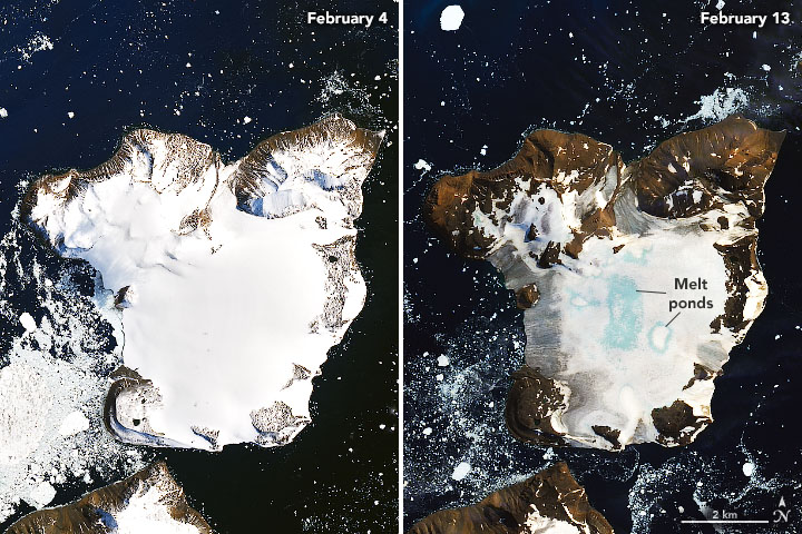 Satellite images acquired by the Operational Land Imager (OLI) show melting on the ice cap of Eagle Island, Antarctica on 4 February 2020 and 13 February 2020. Photo: Joshua Stevens / NASA Earth Observatory
NASA) – On 6 February 2020, weather stations recorded the hottest temperature on record for Antarctica. Thermometers at the Esperanza Base on the northern tip of the Antarctic Peninsula reached 18.3°C (64.9°F)—around the same temperature as Los Angeles that day. The warm spell caused widespread melting on nearby glaciers.
The warm temperatures arrived on February 5 and continued until 13 February 2020. The images above show melting on the ice cap of Eagle Island and were acquired by the Operational Land Imager (OLI) on Landsat 8 on 4 February 2020 and 13 February 2020.
The heat is apparent on the map below, which shows temperatures across the Antarctic Peninsula on 9 February 2020. The map was derived from the Goddard Earth Observing System (GEOS) model, and represents air temperatures at 2 meters (about 6.5 feet) above the ground. The darkest red areas are where the model shows temperatures surpassing 10°C (50°F).
Mauri Pelto, a glaciologist at Nichols College observed that during the warming event, around 1.5 square kilometers (0.9 square miles) of snowpack became saturated with meltwater (shown in blue above). According to climate models, Eagle Island experienced peak melt—30 millimeters (1 inch)—on February 6. In total, snowpack on Eagle Island melted 106 millimeters (4 inches) from February 6- February 11. About 20 percent of seasonal snow accumulation in the region melted in this one event on Eagle Island.
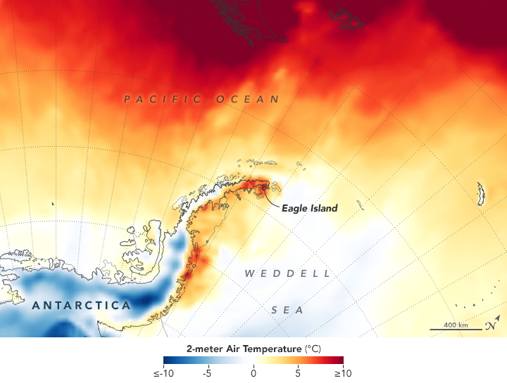 Map showing temperatures across the Antarctic Peninsula on 9 February 2020. The map was derived from the Goddard Earth Observing System (GEOS) model, and represents air temperatures at 2 meters (about 6.5 feet) above the ground. The darkest red areas are where the model shows temperatures surpassing 10°C (50°F). Graphic: Joshua Stevens / NASA Earth Observatory