Welcome to DU!
The truly grassroots left-of-center political community where regular people, not algorithms, drive the discussions and set the standards.
Join the community:
Create a free account
Support DU (and get rid of ads!):
Become a Star Member
Latest Breaking News
General Discussion
The DU Lounge
All Forums
Issue Forums
Culture Forums
Alliance Forums
Region Forums
Support Forums
Help & Search
Environment & Energy
Related: About this forum250,000 Still W/O Power As Next Noreaster Crests The Horizon; Arrival Wednesday/Thursday
Large swells and high tides continued to batter the U.S. East Coast today as a storm that is predicted to become yet another nor’easter began to gather over the Central U.S.
Link to tweet
A broad low pressure system that slammed the mid-Atlantic and Northeastern U.S. this weekend with flooding, massive waves, and wind gusts of up to 93 mph was still hurling rough seas and storm tides at the U.S. East Coast on Monday. Such widely-varied locations as coastal Florida and New Jersey were experiencing high water, beach erosion, raging surf and minor coastal flooding. Officials were warning people to stay off the beach and away from riled seas as crews rushed to clear debris.
The storm gained extreme intensity that was likely peaked by a number of climate change related factors including warmer than normal sea surface temperatures, a blocking high over Greenland that was likely impacted by a recent polar warming event, and higher sea levels resulting increasingly severe tidal flooding during the storm’s peak.
EDIT
Inland, nearly a quarter million people were still without power from Virginia through Maine — down from a high of around two million at the weekend storm’s peak. However, utilities are saying that it may take days to fully restore power to some locations. As repair crews were scrambling, another major storm was starting to gather over the Great Plains — with a high pressure system across Florida drawing very moist air from over a much warmer than normal Gulf of Mexico and into the developing storm’s circulation.
Over the next 24 hours, the new storm is projected to track eastward — crossing to the Ohio River Valley region by late Tuesday. On Wednesday, the low will transition energy into a developing storm off Virginia and the Outer Banks. This low is then expected to rapidly intensify as it moves northward — developing strong onshore winds with gusts of 45-65 mph crossing coastal Delaware, New Jersey, Long Island, Connecticut, Rhode Island and Massachusetts by late Wednesday and into early Thursday.
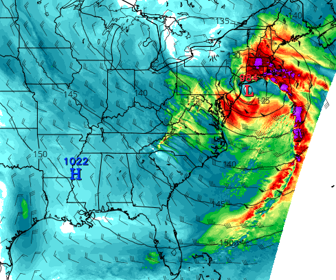 ?w=600
(Models show another powerful low pressure system battering the Northeast Coast with 45-65 mph winds by early Thursday. Image source: Tropical Tidbits.)
The storm is also predicted to bring heavy coastal rains and up to 1-2 feet of snow across parts of the Northeast. Presently, the storm is not expected to be as strong as the massive system that slammed the Northeast and Mid-Atlantic this weekend. However, gale force to storm force gusts are presently predicted, and forecast storm strength has been trending toward higher intensity in recent model runs.
EDIT
https://robertscribbler.com/2018/03/05/east-coast-still-experiencing-heavy-seas-as-another-storm-looms/
InfoView thread info, including edit history
TrashPut this thread in your Trash Can (My DU » Trash Can)
BookmarkAdd this thread to your Bookmarks (My DU » Bookmarks)
1 replies, 560 views
ShareGet links to this post and/or share on social media
AlertAlert this post for a rule violation
PowersThere are no powers you can use on this post
EditCannot edit other people's posts
ReplyReply to this post
EditCannot edit other people's posts
Rec (4)
ReplyReply to this post
1 replies
 = new reply since forum marked as read
Highlight:
NoneDon't highlight anything
5 newestHighlight 5 most recent replies
= new reply since forum marked as read
Highlight:
NoneDon't highlight anything
5 newestHighlight 5 most recent replies
= new reply since forum marked as read
Highlight:
NoneDon't highlight anything
5 newestHighlight 5 most recent replies
250,000 Still W/O Power As Next Noreaster Crests The Horizon; Arrival Wednesday/Thursday (Original Post)
hatrack
Mar 2018
OP

Canoe52
(2,948 posts)1. Nothing to see, this is not a changing climate, move along...
