Environment & Energy
Related: About this forumNASA Study: Most Of Southern Greenland Ice Sheet Is Melting From Below; Parts Of Northern Sheet, Too
A new scientific study headed by NASA researchers has developed one of the first comprehensive maps of melt along Greenland’s basal zone, where the ice contacts the ground surface. What they have found is that large portions of Greenland are melting from below:
 ?w=777&h=1404
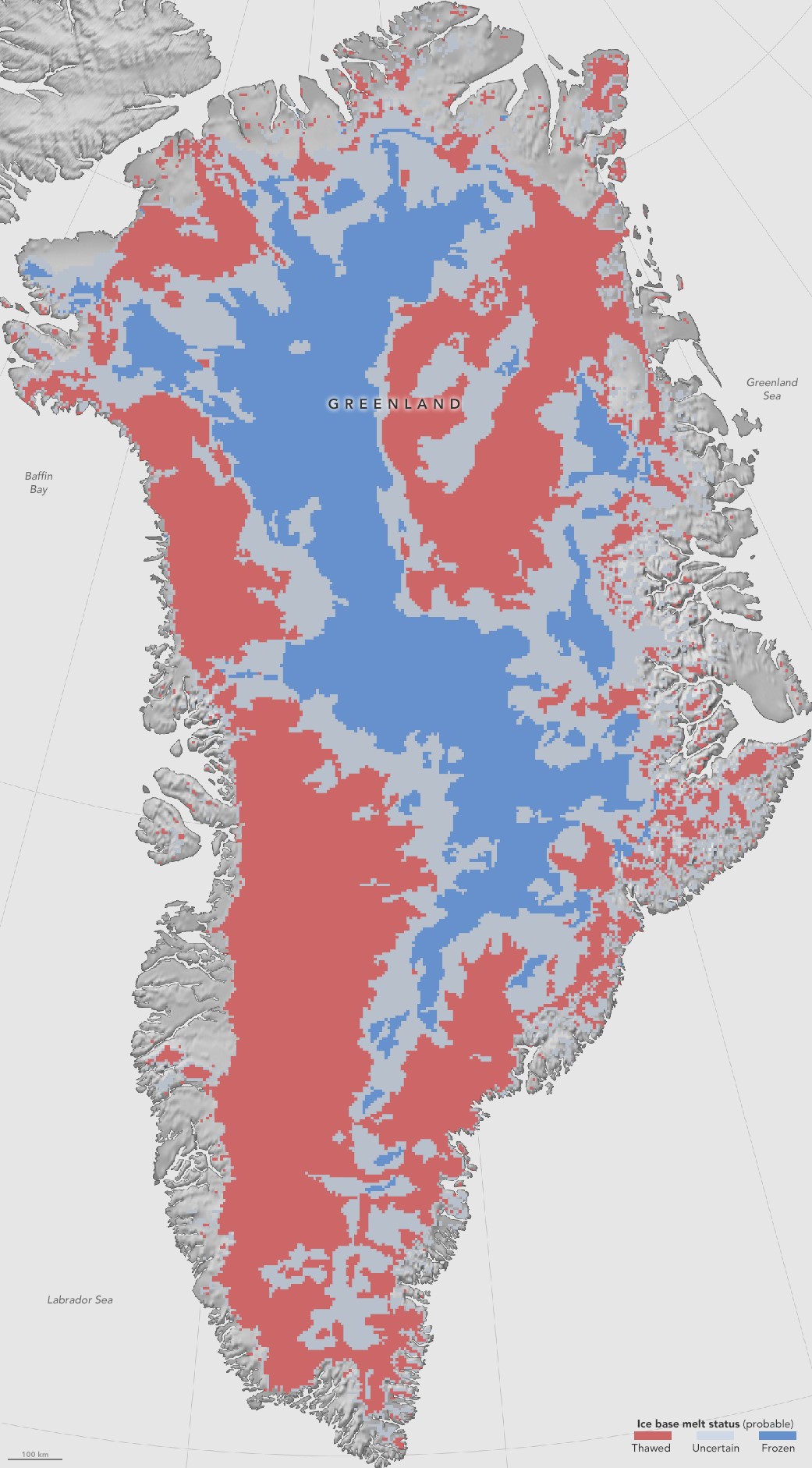
(New, first-of-its-kind map shows extensive melt along the Greenland ice sheet base. Melt in this region is a sign that heat is building up beneath the ice as well as on top. Image source: NASA.)
This mapping study found that wide expanses of northern Greenland and pretty much all of southern Greenland are now experiencing melt at the ice sheet base. As the interior of Greenland has a cracked-bowl topography — with land bowing down into a central trough and numerous furrows connecting the ice sheet with the ocean — understanding where liquid water and heat are pooling at the bottom of the ice sheet will help scientists to get a better idea of how Greenland’s glaciers will respond to human-forced warming. Joe MacGregor, lead study author and glaciologist at NASA’s Goddard Space Flight Center in Greenbelt, Maryland recently noted:
“We’re ultimately interested in understanding how the ice sheet flows and how it will behave in the future. If the ice at its bottom is at the melting-point temperature, or thawed, then there could be enough liquid water there for the ice to flow faster and affect how quickly it responds to climate change.”
EDIT
The way this heat transfer works is that rising temperatures over Greenland form more extensive surface lakes and melt ponds during the increasingly warm summers (and sometimes briefly during other periods). Often, the meltwater will find a crack in the ice and flow down to the ice interior. Sometimes the water remains suspended in the middle layers between the surface and the ice sheet base as a kind of heat bubble. At other times, the water will bore all the way down to the ground where it can form into pools or subglacial lakes.
At Flade Isblink in northeastern Greenland, such a filling of a subglacial lake was observed during the 2011 and 2012 melt years. As Greenland warms, such instances are likely to become more common. In this way, melt at the surface can add to the amount of heat trapped below the ice sheet — forming a kind of synergistic melt process. The new NASA study helps our understanding of how such a process might unfold by showing the current extent of subsurface melt. The study combined physical models with observations to create this larger picture of bottom melt, telling a dramatic story of the opening period of human-forced Greenland melt, in which sub-surface melt is already very extensive.
EDIT
 ?w=600
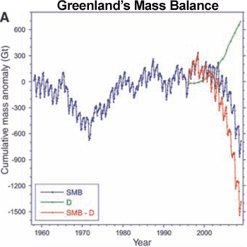
(Losses of Greenland mass from the surface zone have been accelerating during recent years. This loss has primarily been driven by human-forced warming of the Arctic. Though the North Atlantic Oscillation can generate melt variability by driving warm air flows toward or away from Greenland, the overall long-term driver has been a rapid warming of the Arctic region due to fossil-fuel emissions. Though we have a pretty good understanding of surface melt, our understanding of melt at the base of the ice sheet and heat accumulation there is less complete. Such an understanding may help us to predict future ice sheet behavior. Image source: Skeptical Science.)
EDIT
https://robertscribbler.com/2016/08/09/nasa-map-shows-large-portions-of-greenland-are-melting-from-below/
 = new reply since forum marked as read
Highlight:
NoneDon't highlight anything
5 newestHighlight 5 most recent replies
= new reply since forum marked as read
Highlight:
NoneDon't highlight anything
5 newestHighlight 5 most recent replies

OKIsItJustMe
(19,938 posts)[font size=5]NASA: First Map Of Thawed Areas Under Greenland Ice Sheet[/font]
[font size=3]NASA researchers have helped produce the first map showing what parts of the bottom of the massive Greenland Ice Sheet are thawed – key information in better predicting how the ice sheet will react to a warming climate.
Greenland’s thick ice sheet insulates the bedrock below from the cold temperatures at the surface, so the bottom of the ice is often tens of degrees warmer than at the top, because the ice bottom is slowly warmed by heat coming from the Earth’s depths. Knowing whether Greenland’s ice lies on wet, slippery ground or is anchored to dry, frozen bedrock is essential for predicting how this ice will flow in the future, But scientists have very few direct observations of the thermal conditions beneath the ice sheet, obtained through fewer than two dozen boreholes that have reached the bottom. Now, a new study synthesizes several methods to infer the Greenland Ice Sheet’s basal thermal state –whether the bottom of the ice is melted or not– leading to the first map that identifies frozen and thawed areas across the whole ice sheet.
…
From this synthesis, MacGregor and his colleagues determined that the bed is likely thawed under Greenland’s southwestern and northeastern ice drainages, while it’s frozen in the interior and west of the ice sheet’s central ice divide. For a third of the Greenland ice sheet, there’s not enough data available to determine its basal thermal state.
MacGregor said the team’s map is just one step in fully assessing the thermal state of the bottom of Greenland’s ice sheet.
“I call this the piñata, because it’s a first assessment that is bound to get beat up by other groups as techniques improve or new data are introduced. But that still makes our effort essential, because prior to our study, we had little to pick on,” MacGregor said.[/font][/font]

Nitram
(22,822 posts)
CrispyQ
(36,478 posts)
Judi Lynn
(160,545 posts)