Welcome to DU!
The truly grassroots left-of-center political community where regular people, not algorithms, drive the discussions and set the standards.
Join the community:
Create a free account
Support DU (and get rid of ads!):
Become a Star Member
Latest Breaking News
General Discussion
The DU Lounge
All Forums
Issue Forums
Culture Forums
Alliance Forums
Region Forums
Support Forums
Help & Search
Video & Multimedia
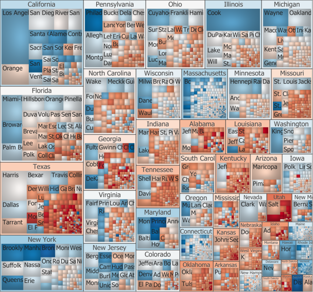
Related: About this forumCool map of the 2012 presidential election results - image

Treemap of votes by county, state and locally predominant recipient in the US Presidential Elections of 2012.
Note: Hundreds of thousands ballots still not counted in Arizona.
InfoView thread info, including edit history
TrashPut this thread in your Trash Can (My DU » Trash Can)
BookmarkAdd this thread to your Bookmarks (My DU » Bookmarks)
7 replies, 2651 views
ShareGet links to this post and/or share on social media
AlertAlert this post for a rule violation
PowersThere are no powers you can use on this post
EditCannot edit other people's posts
ReplyReply to this post
EditCannot edit other people's posts
Rec (2)
ReplyReply to this post
7 replies
 = new reply since forum marked as read
Highlight:
NoneDon't highlight anything
5 newestHighlight 5 most recent replies
Cool map of the 2012 presidential election results - image (Original Post)
Tx4obama
Nov 2012
OP
dae
(3,396 posts)1. Do you have a link? Thanks for posting.
Tx4obama
(36,974 posts)2. The map is up in the OP. Can you see it?
If you want to go to the page the map is on go here: http://en.wikipedia.org/wiki/2012_presidential_election_results#Results
It is on the right side of the page.
dae
(3,396 posts)5. Got it, thanks, very cool.
Love Wikipedia!
![]()
NYC_SKP
(68,644 posts)3. treemap, used here:
dae
(3,396 posts)6. Thanks, I have it now.
Blue4Texas
(437 posts)4. Very cool. Thank you
Caroline-Vivienne
(117 posts)7. Look at my Texas!!!
Turning lighter and lighter pink!!!
Not 2016, but in 2020 we could make the Repubs sweat a bit...
And if we control the next census and redistricting?????
2024 could be a fantastic election!!!
It really is only a matter of time.