Video & Multimedia
Related: About this forumVirtual Fly Through of the Washington State Wildfires (fascinating and terrifying!)

Information updated through August 28 at 2:00AM PDT. A virtual fly through of the public MODIS+VIIRS Fire Data from the US Forest Service for the Chelan Complex Fire, the Okanogan Complex Fire, and other fires in North Central Washington State. The fly through starts above the US, then flys in on the Pacfic North West, then Central Washington, before flying in on the fire areas.
Chelan Complex and Okanogan Complex Wildfire Fly Through updated on 8-28-2015 based on data captured from 8-26-2015 through 2:00AM PDT 8-28-2015.
Data color is based on MODIS fire activity with Red representing activity detected in the last 0-12 hours (at the time data was updated). Orange represent activity in the last 12-24 hours ago, and Yellow data is 24 hours or older (up to 6 days).
 = new reply since forum marked as read
Highlight:
NoneDon't highlight anything
5 newestHighlight 5 most recent replies
= new reply since forum marked as read
Highlight:
NoneDon't highlight anything
5 newestHighlight 5 most recent replies
calikid
(584 posts)I wish they had one for the Northern California fires.
Thanks for posting fan of poker

pokerfan
(27,677 posts)Though they're red from all this smoke I'll keep my eyes open for one.
The raw data for all states) can be found here: http://activefiremaps.fs.fed.us/googleearth.php
calikid
(584 posts)
AtheistCrusader
(33,982 posts)So many people live near those fires. I anticipate my employer will be allowing people to take time off to go help fight the fires before long without consuming vacation.
It's bad. Very bad.

JDPriestly
(57,936 posts)The heat?
What is the cause?
AtheistCrusader
(33,982 posts)Lightning can explain it all, but I'm sure some of them are human stupidity.
pokerfan
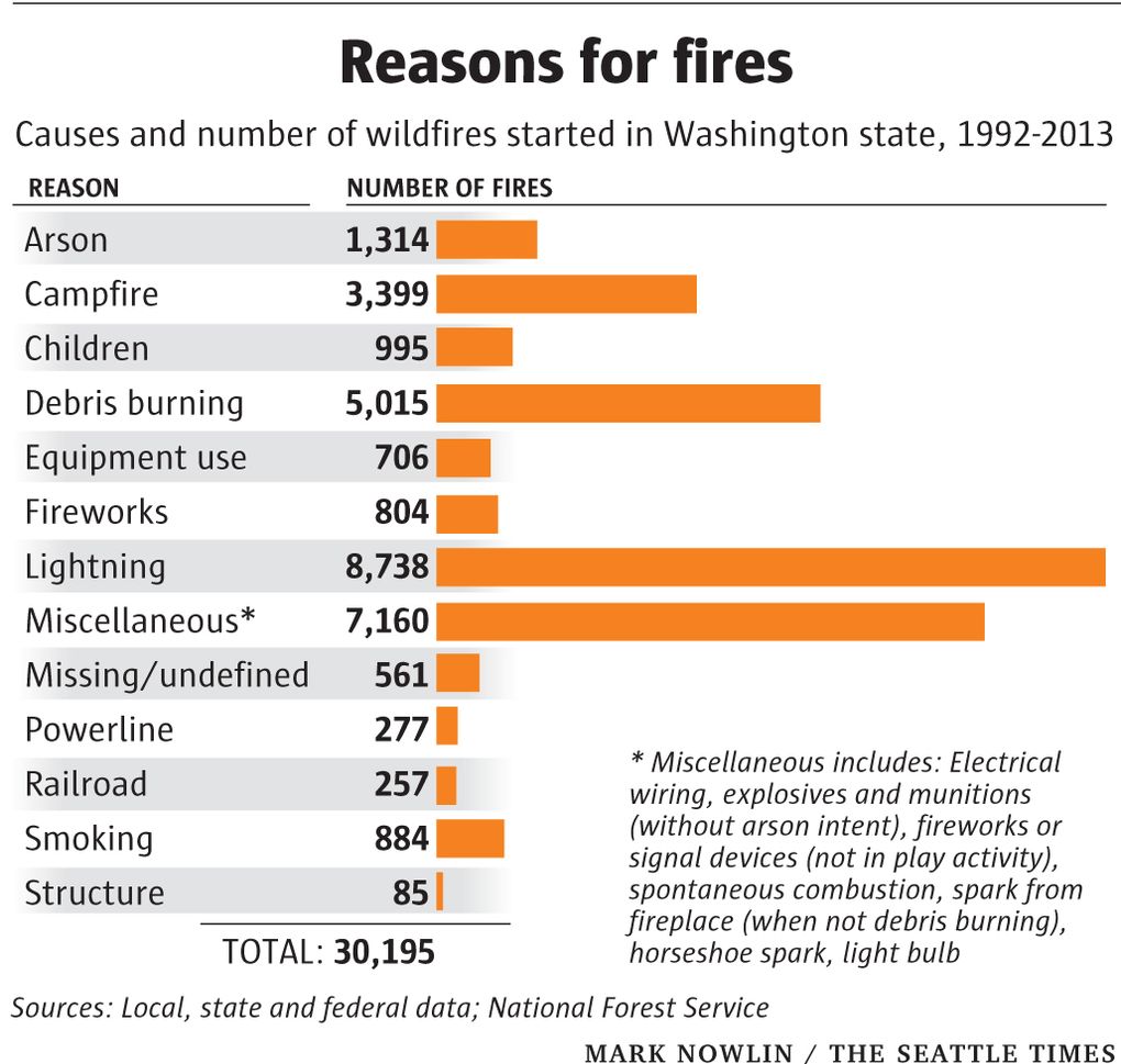
(27,677 posts)Multiple causes. Lightning leads the list but also campfires, trash burning, fireworks, smoking, railroads, arson, etc.
Contributing causes:
• Unhealthy forests and grasslands
• Government spending less on fire prevention
• Drought
• More people living in wildland areas = more structures to protect
• Climate change only makes things worse
http://www.seattletimes.com/seattle-news/northwest/why-we-have-such-damaging-wildfires-this-summer/

miamipilot
(82 posts)It has been a dense smoky haze that has settled in this area for about a week now. Record level doctor visits for people with pre-existing respiratory illnesses. Irritating to the eyes and throat for everybody else.

MrMickeysMom
(20,453 posts)Thank you… (gulp)