UPDATE2: Hurricane Michael strengthens to Category 3, on collision course with Florida Gulf Coast
Last edited Tue Oct 9, 2018, 05:02 PM - Edit history (1)
Source: Washington Post
ALERT: The hurricane’s peak winds reached 120 mph as of 5 p.m. Tuesday, which is Category 3 or a major hurricane on the Saffir-Simpson wind scale, according to the National Hurricane Center.
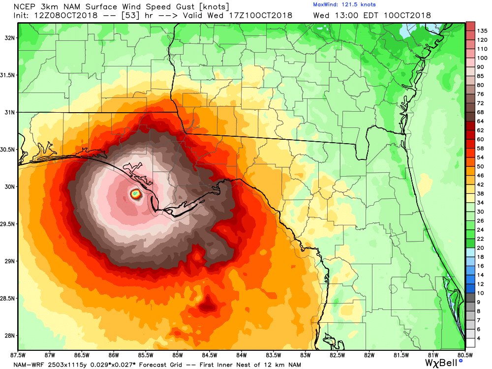
Florida’s northern Gulf Coast faces its most serious hurricane threat in more than a decade as Michael edges ever closer. The intensifying storm is likely to make landfall Wednesday as a Category 3 hurricane, and conditions will begin to deteriorate Tuesday night.
Florida’s Panhandle, from Pensacola to Apalachicola, and its Big Bend area are the zones of greatest concern. Michael is poised to push ashore a “life-threatening” surge of ocean water that will inundate more than 325 miles of coastline. The storm also will unleash destructive winds and flooding rain starting late Tuesday night and continuing through Wednesday.
Read more: https://www.washingtonpost.com/weather/2018/10/09/hurricane-michael-churns-toward-floridas-gulf-coast-while-quickly-gaining-strength/?noredirect=on&utm_term=.1b2da663161f

Update 1 story -
The hurricane peak winds reached 110 mph as of 11 a.m. Tuesday, just 1 mph shy of Category 3, according to the National Hurricane Center.
Florida's Panhandle, from Pensacola to Apalachicola, and its Big Bend area are the zones of greatest concern. Michael is poised to push ashore a "life-threatening" surge of ocean water that will inundate those coastal areas. The storm also will unleash flooding rain and destructive winds starting Tuesday night and continuing through Wednesday.
"There are warnings for more than 300 miles of coastline," the National Weather Service tweeted, predicting that Michael will become a "large and dangerous hurricane."
Original story -
The storm's winds have increased to near 100 mph as of 8 a.m., according to the National Hurricane Center. Michael is forecast to strengthen to a Category 3 prior to landfall Wednesday on the Florida Panhandle.
This is a developing story and will be updated.
Florida's northern Gulf Coast faces its most serious hurricane threat in more than a decade as Michael edges ever closer. The intensifying storm is likely to make landfall Wednesday as a Category 3 hurricane, and conditions will begin to deteriorate Tuesday night.
Florida's Panhandle, from Pensacola to Apalachicola, and its Big Bend area are the zones of greatest concern. Michael is poised to push ashore a "life-threatening" surge of ocean water that will inundate those coastal areas. The storm also will unleash flooding rain and destructive winds starting Tuesday night and continuing through Wednesday.
 = new reply since forum marked as read
Highlight:
NoneDon't highlight anything
5 newestHighlight 5 most recent replies
= new reply since forum marked as read
Highlight:
NoneDon't highlight anything
5 newestHighlight 5 most recent replies
Baclava
(12,047 posts)


BumRushDaShow
(129,137 posts)and it was expected that the data would tighten up the paths in the spaghetti models.

Scurrilous
(38,687 posts)

George II
(67,782 posts)....zoom in or out, or scroll the map similar to scrolling google maps.
It shows the path over about two weeks.
https://www.windy.com/?27.372,-84.792,6,i:deg0
BumRushDaShow
(129,137 posts)Here is another - https://earth.nullschool.net/#current/wind/surface/level/orthographic=-86.34,23.85,1821
I always thought these were pretty cool. 
George II
(67,782 posts)....the "play" button (triangle) in the lower left of mine, the animation starts and shows where the storm will go from today into next week.
BumRushDaShow
(129,137 posts)and if you click on it, there is an option on the popup that looks like it offers "controls" to go back or forward. Plus you can select different parameters for the standard atmospheric pressures ("heights" for upper, middle, surface levels ) and add temperature overlays etc. I haven't had time to play with it as I'm bopping between hobbies - including posting on DU, tracking Michael, and trying to prepare some potted tropical plants to come inside tomorrow (soaking pots and about to spray them with insecticidal soap)! 

nitpicker
(7,153 posts)Hurricane Michael Intermediate Advisory Number 12A
NWS National Hurricane Center Miami FL AL142018
100 PM CDT Tue Oct 09 2018
...EYE OF DANGEROUS HURRICANE MICHAEL MOVING NORTHWARD OVER THE
EASTERN GULF OF MEXICO...
...LIFE-THREATENING STORM SURGE...HURRICANE FORCE WINDS...AND HEAVY
RAINFALL EXPECTED ALONG THE NORTHEASTERN GULF COAST...
SUMMARY OF 100 PM CDT...1800 UTC...INFORMATION
----------------------------------------------
LOCATION...25.4N 86.4W
ABOUT 335 MI...540 KM S OF PANAMA CITY FLORIDA
ABOUT 310 MI...500 KM SSW OF APALACHICOLA FLORIDA
MAXIMUM SUSTAINED WINDS...110 MPH...175 KM/H
PRESENT MOVEMENT...N OR 350 DEGREES AT 12 MPH...19 KM/H
MINIMUM CENTRAL PRESSURE...965 MB...28.50 INCHES
WATCHES AND WARNINGS
--------------------
CHANGES WITH THIS ADVISORY:
None
SUMMARY OF WATCHES AND WARNINGS IN EFFECT:
A Storm Surge Warning is in effect for...
* Okaloosa/Walton County Line Florida to Anclote River Florida
A Storm Surge Watch is in effect for...
* Anclote River Florida to Anna Maria Island Florida, including
Tampa Bay
* Alabama/Florida border to Okaloosa/Walton County Line Florida
A Hurricane Warning is in effect for...
* Alabama/Florida border to Suwannee River Florida
A Tropical Storm Warning is in effect for...
* Alabama/Florida border to the Mississippi/Alabama border
* Suwanee River Florida to Chassahowitzka Florida
A Tropical Storm Watch is in effect for...
* Chassahowitzka to Anna Maria Island Florida, including Tampa Bay
* Mississippi/Alabama border to the Mouth of the Pearl River
* Fernandina Beach Florida to South Santee River South Carolina
A Storm Surge Warning means there is a danger of life-threatening
inundation, from rising water moving inland from the coastline,
during the next 36 hours in the indicated locations. For a depiction
of areas at risk, please see the National Weather Service Storm
Surge Watch/Warning Graphic, available at hurricanes.gov. This is a
life-threatening situation. Persons located within these areas
should take all necessary actions to protect life and property from
rising water and the potential for other dangerous conditions.
Promptly follow evacuation and other instructions from local
officials.
A Hurricane Warning means that hurricane conditions are expected
somewhere within the warning area, in this case within the next
24 hours. Preparations to protect life and property should be
rushed to completion.
A Tropical Storm Warning means that tropical storm conditions are
expected somewhere within the warning area, in this case within the
next 12 to 24 hours.
A Storm Surge Watch means there is a possibility of life-
threatening inundation, from rising water moving inland from the
coastline.
A Tropical Storm Watch means that tropical storm conditions are
possible within the watch area.
Interests elsewhere across the southeastern United States should
monitor the progress of Michael.
For storm information specific to your area, including possible
inland watches and warnings, please monitor products issued by your
local National Weather Service forecast office.
DISCUSSION AND OUTLOOK
----------------------
At 100 PM CDT (1800 UTC), the eye of Hurricane Michael was located
near latitude 25.4 North, longitude 86.4 West. Michael is moving
toward the north near 12 mph (19 km/h). A northward motion is
expected through tonight, followed by a northeastward motion on
Wednesday and Thursday. On the forecast track, the center of
Michael will move across the eastern Gulf of Mexico through tonight.
The center of Michael is then expected to move inland over the
Florida Panhandle or Florida Big Bend area on Wednesday, and then
move northeastward across the southeastern United States Wednesday
night and Thursday, and move off the Mid-Atlantic coast away from
the United States by Friday.
Data from an Air Force Reserve Hurricane Hunter aircraft indicate
that the maximum sustained winds are near 110 mph (175 km/h) with
higher gusts. Additional strengthening is expected, and Michael is
forecast to be a major hurricane at landfall in Florida. Weakening
is expected after landfall as Michael moves through the southeastern
United States.
Hurricane-force winds extend outward up to 35 miles (55 km) from
the center and tropical-storm-force winds extend outward up to 185
miles (295 km). NOAA buoy 42003 recently reported 1-minute mean
winds of 54 mph (87 km/h) and a wind gust of 59 mph (94 km/h).
The latest minimum central pressure based on data from the aircraft
is 965 mb (28.50 inches).
HAZARDS AFFECTING LAND
----------------------
STORM SURGE: The combination of a dangerous storm surge and the
tide will cause normally dry areas near the coast to be flooded by
rising waters moving inland from the shoreline. The water has the
potential to reach the following heights above ground if peak surge
occurs at the time of high tide...
Indian Pass FL to Cedar Key FL...8-12 ft
Cedar Key FL to Crystal River FL...6-8 ft
Okaloosa/Walton County Line FL to Indian Pass FL...6-9 ft
Crystal River FL to Aripeka FL...4-6 ft
Aripeka FL to Anna Maria Island FL including Tampa Bay...2-4 ft
Alabama/Florida border to Okaloosa/Walton County Line FL...2-4 ft
WIND: Hurricane conditions are expected within the hurricane
warning area along the U.S. Gulf Coast by Wednesday, with tropical
storm conditions expected by tonight or early Wednesday. Hurricane
conditions will also spread well inland across portions of the
Florida Panhandle, southeastern Alabama and southwestern Georgia.
Tropical storm conditions are expected in the tropical storm warning
area by tonight or early Wednesday, and are possible within the
tropical storm watch area by that time. Hurricane conditions are
possible within the hurricane watch area by Wednesday.
Tropical storm conditions are possible in the watch area along the
southeast U.S. coast Wednesday night and Thursday.
RAINFALL: Michael is expected to produce the following rainfall
amounts through Friday...
Western Cuba...4 to 8 inches, with isolated maximum amounts of 12
inches. This rainfall could lead to life-threatening flash floods
and mudslides.
Florida Panhandle and Big Bend, southeast Alabama, and southern
Georgia...4 to 8 inches, with isolated maximum amounts of 12 inches.
This rainfall could lead to life threatening flash floods.
Eastern Georgia, the Carolinas, and southern Virginia...3 to 6
inches. This rainfall could lead to life-threatening flash floods.
Florida Peninsula, eastern Mid Atlantic, southern New England
coast...1-3 inches.
SURF: Swells generated by Michael are affecting the coasts of the
eastern and northern Gulf of Mexico, and will spread to portions of
the northwestern and western Gulf of Mexico coast during the next
day or so. These swells are likely to cause life-threatening surf
and rip current conditions. Please consult products from your local
weather office.
TORNADOES: The threat for tornadoes will increase late tonight into
Wednesday over parts of the Florida Panhandle, the northern Florida
Peninsula, and southern Georgia.
NEXT ADVISORY
-------------
Next complete advisory at 400 PM CDT.
$$
Forecaster Brown
Hurricane Michael Discussion Number 12
NWS National Hurricane Center Miami FL AL142018
1000 AM CDT Tue Oct 09 2018
Michael has continued to become better organized this morning. The
hurricane has become more symmetric with the eye becoming more
apparent in infrared and visible satellite imagery. Data from both
NOAA and U.S. Air Force Reserve Hurricane Hunter aircraft show
that the minimum pressure has dropped to around 965 mb, and a blend
of the flight-level and SFMR winds support an initial intensity of
95 kt for this advisory. With two aircraft in the storm, they have
been able to sample each of the four quadrants a couple of times
this morning, providing better confidence in the analyzed wind
field. The planes actually passed through the eye around the same
time just before 1200 UTC, and reported that they could see one
another.
The outflow pattern has become better established over the
hurricane, but there is still a little evidence of some westerly
shear. The shear should continue to decrease, and further
strengthening is expected until landfall on Wednesday. Michael is
expected to become a major hurricane later today, and remain a
dangerous major hurricane through landfall. Significant weakening
should occur as the center moves inland over the southeastern United
States, but re-strengthening as an extratropical low is expected
when the system moves over the western Atlantic.
Michael is moving between north-northwest and north at about 10 kt.
The track forecast reasoning is the same as the past several
advisories, as Michael should move generally northward through early
Wednesday between a ridge over the western Atlantic and a deep-layer
trough over the central United States. As the trough moves eastward
it will cause Michael to turn northeastward on Wednesday. The
hurricane should then continue northeastward and accelerate as it
becomes embedded in the mid-latitude westerlies. The track guidance
is in very good agreement through the first 36-48 hours, with some
differences in forward speed thereafter. The GFS and ECMWF have
trended slower after landfall, and the new NHC track has been
adjusted accordingly.
Key Messages:
1. Life-threatening storm surge is likely along portions of the
coasts of the Florida Panhandle, Big Bend, and Nature Coast, and a
storm surge warning is in effect for these areas. Water levels will
rise well in advance of the center of Michael, and residents within
the storm surge warning area should finish preparations to protect
life and property today.
2. Everyone in the hurricane warning area along the Florida Gulf
Coast should prepare for life-threatening major hurricane winds
associated with the core of Michael. Hurricane force winds will also
extend well inland across portions of the Florida Panhandle,
southern Georgia, and southeast Alabama as Michael moves inland.
3. Heavy rainfall from Michael could produce life-threatening flash
flooding from the Florida Panhandle and Big Bend region into
portions of Georgia and South Carolina.
4. Michael is expected to produce heavy rainfall and flash flooding
over portions of western Cuba during the next day or so.
FORECAST POSITIONS AND MAX WINDS
INIT 09/1500Z 25.0N 86.2W 95 KT 110 MPH
12H 10/0000Z 26.7N 86.5W 105 KT 120 MPH
24H 10/1200Z 28.8N 86.3W 110 KT 125 MPH
36H 11/0000Z 30.8N 85.1W 75 KT 85 MPH...INLAND
48H 11/1200Z 33.0N 82.5W 45 KT 50 MPH...INLAND
72H 12/1200Z 37.5N 74.0W 50 KT 60 MPH...POST-TROP/EXTRATROP
96H 13/1200Z 44.0N 56.0W 60 KT 70 MPH...POST-TROP/EXTRATROP
120H 14/1200Z 50.0N 38.0W 55 KT 65 MPH...POST-TROP/EXTRATROP
$$
Forecaster Brown
BumRushDaShow
(129,137 posts)
BumRushDaShow
(129,137 posts)Link to tweet
TEXT
National Hurricane Center
✔
@NHC_Atlantic
Hurricane #Michael Advisory 13: Michael Strengthens to a Major Hurricane. Life-Threatening Storm Surge. http://go.usa.gov/W3H
4:56 PM - Oct 9, 2018
BumRushDaShow
(129,137 posts)
Baclava
(12,047 posts)Waiting.....
BumRushDaShow
(129,137 posts)I think the last I saw was that the eye may have finally closed.


hatrack
(59,587 posts)000
WTNT34 KNHC 092344
TCPAT4
BULLETIN
Hurricane Michael Intermediate Advisory Number 13A
NWS National Hurricane Center Miami FL AL142018
700 PM CDT Tue Oct 09 2018
...MAJOR HURRICANE MICHAEL GETTING MUCH BETTER ORGANIZED...
...LIFE-THREATENING STORM SURGE...HURRICANE FORCE WINDS...AND HEAVY
RAINFALL EXPECTED ALONG THE NORTHEASTERN GULF COAST...
SUMMARY OF 700 PM CDT...0000 UTC...INFORMATION
----------------------------------------------
LOCATION...26.6N 86.5W
ABOUT 255 MI...410 KM S OF PANAMA CITY FLORIDA
ABOUT 235 MI...375 KM SSW OF APALACHICOLA FLORIDA
MAXIMUM SUSTAINED WINDS...120 MPH...195 KM/H
PRESENT MOVEMENT...N OR 350 DEGREES AT 12 MPH...19 KM/H
MINIMUM CENTRAL PRESSURE...953 MB...28.14 INCHES
WATCHES AND WARNINGS
--------------------
CHANGES WITH THIS ADVISORY:
None.
SUMMARY OF WATCHES AND WARNINGS IN EFFECT:
A Storm Surge Warning is in effect for...
* Okaloosa/Walton County Line Florida to Anclote River Florida
A Storm Surge Watch is in effect for...
* Anclote River Florida to Anna Maria Island Florida, including
Tampa Bay
* Alabama/Florida border to Okaloosa/Walton County Line Florida
A Hurricane Warning is in effect for...
* Alabama/Florida border to Suwannee River Florida
A Tropical Storm Warning is in effect for...
* Alabama/Florida border to the Mississippi/Alabama border
* Suwanee River Florida to Chassahowitzka Florida
* Fernandina Beach Florida to South Santee River South Carolina
A Tropical Storm Watch is in effect for...
* Chassahowitzka to Anna Maria Island Florida, including Tampa Bay
* Mississippi/Alabama border to the Mouth of the Pearl River
* South Santee River South Carolina to Duck North Carolina
* Pamlico and Albemarle Sounds
A Storm Surge Warning means there is a danger of life-threatening
inundation, from rising water moving inland from the coastline,
during the next 36 hours in the indicated locations. For a depiction
of areas at risk, please see the National Weather Service Storm
Surge Watch/Warning Graphic, available at hurricanes.gov. This is a
life-threatening situation. Persons located within these areas
should take all necessary actions to protect life and property from
rising water and the potential for other dangerous conditions.
Promptly follow evacuation and other instructions from local
officials.
A Hurricane Warning means that hurricane conditions are expected
somewhere within the warning area, in this case within the next
24 hours. Preparations to protect life and property should be
rushed to completion.
A Tropical Storm Warning means that tropical storm conditions are
expected somewhere within the warning area.mb (millibars)
A Storm Surge Watch means there is a possibility of life-
threatening inundation, from rising water moving inland from the
coastline.
A Tropical Storm Watch means that tropical storm conditions are
possible within the watch area.
Interests elsewhere across the southeastern United States should
monitor the progress of Michael.
For storm information specific to your area, including possible
inland watches and warnings, please monitor products issued by your
local National Weather Service forecast office.
DISCUSSION AND OUTLOOK
----------------------
At 700 PM CDT (0000 UTC), the eye of Hurricane Michael was located
near latitude 26.6 North, longitude 86.5 West. Michael is moving
toward the north near 12 mph (19 km/h). A northward motion is
expected through tonight, followed by a northeastward motion on
Wednesday and Thursday. On the forecast track, the center of Michael
will move across the eastern Gulf of Mexico through tonight. The
center of Michael's eye is then expected to move inland over the
Florida Panhandle or Florida Big Bend area on Wednesday, and then
move northeastward across the southeastern United States Wednesday
night and Thursday, and move off the Mid-Atlantic coast away from
the United States on Friday.
Maximum sustained winds are near 120 mph (195 km/h) with higher
gusts. Michael is a category 3 hurricane on the Saffir-Simpson
Hurricane Wind Scale. Strengthening is expected overnight and on
Wednesday, and Michael is forecast to be near category 4 strength
when it makes landfall in the Florida Panhandle or the Florida Big
Bend area. Weakening is expected after landfall as Michael moves
across the southeastern United States.
Hurricane-force winds extend outward up to 45 miles (75 km) from
the center and tropical-storm-force winds extend outward up to 175
miles (280 km).
The latest minimum central pressure based on data from an Air Force
Reserve Hurricane Hunter aircraft is 953 mb (28.14 inches).
HAZARDS AFFECTING LAND
----------------------
STORM SURGE: The combination of a dangerous storm surge and the
tide will cause normally dry areas near the coast to be flooded by
rising waters moving inland from the shoreline. The water has the
potential to reach the following heights above ground if peak surge
occurs at the time of high tide...
Mexico Beach FL to Keaton Beach FL...9-13 ft
Okaloosa/Walton County Line FL to Mexico Beach FL...6-9 ft
Keaton Beach FL to Cedar Key FL...6-9 ft
Cedar Key FL to Chassahowitzka FL...4-6 ft
Chassahowitzka to Anna Maria Island FL including Tampa Bay...2-4 ft
Alabama/Florida border to Okaloosa/Walton County Line FL...2-4 ft
WIND: Hurricane conditions are expected within the hurricane
warning area along the U.S. Gulf Coast by Wednesday, with tropical
storm conditions expected by tonight or early Wednesday. Hurricane
conditions will also spread well inland across portions of the
Florida Panhandle, southeastern Alabama and southwestern Georgia.
Tropical storm conditions are expected in the tropical storm warning
area by tonight or early Wednesday, and are possible within the
tropical storm watch area by that time. Hurricane conditions are
possible within the hurricane watch area by Wednesday.
Tropical storm conditions are expected in the warning area along
the southeast U.S. coast by Wednesday, and possible in the watch
area by late Wednesday.
RAINFALL: Michael is expected to produce the following rainfall
amounts through Friday...
Florida Panhandle and Big Bend, southeast Alabama, and portions of
southwest and central Georgia...4 to 8 inches, with isolated maximum
amounts of 12 inches. This rainfall could lead to life threatening
flash floods.
The remainder of Georgia, the Carolinas, and southern Virginia...3
to 6 inches, with isolated maximum amounts of 8 inches. This
rainfall could lead to life-threatening flash floods.
Florida Peninsula, eastern Mid Atlantic, southern New England
coast...1-3 inches.
Western Cuba...An additional 1 to 2 inches.
SURF: Swells generated by Michael are affecting the coasts of the
eastern and northern Gulf of Mexico, and will spread to portions of
the northwestern and western Gulf of Mexico coast during the next
day or so. These swells are likely to cause life-threatening surf
and rip current conditions. Please consult products from your local
weather office.
TORNADOES: The threat for tornadoes will increase late tonight into
Wednesday over parts of the Florida Panhandle, the northern Florida
Peninsula, and southern Georgia.
NEXT ADVISORY
-------------
Next complete advisory at 1000 PM CDT.
$$
Forecaster Stewart
