UPDATED: M7.8 Z=19km 23:58 4/16 UTC, 27 km SSE of Muisne, Ecuador
Source: USGS
Read more: http://earthquake.usgs.gov/earthquakes/eventpage/us20005j32#general
 = new reply since forum marked as read
Highlight:
NoneDon't highlight anything
5 newestHighlight 5 most recent replies
= new reply since forum marked as read
Highlight:
NoneDon't highlight anything
5 newestHighlight 5 most recent replies

bkkyosemite
(5,792 posts)RepubliCON-Watch
(559 posts)
LiberalArkie
(15,728 posts)I wonder if that could be affecting the earthquakes.

blm
(113,083 posts)Geez…this is grim.

LastLiberal in PalmSprings
(12,591 posts)Except in Fairbanks, Alaska, where you have to drive south to get to North Pole.
LiberalArkie
(15,728 posts)It said like spinning a top is centered but if you put a tiny bit of weight it will change the angle of the spin.
Here ya go, I found it
http://www.huffingtonpost.com/entry/earth-poles-climate-change_us_5706c52ee4b0537661892db4
http://astronomynow.com/2016/04/11/climate-change-creates-wobbles-in-earths-spin-axis/
LastLiberal in PalmSprings
(12,591 posts)and we had to take both the precession and nutation changes (interacting short term and long term wobbles) into account when we were doing celestial navigation.
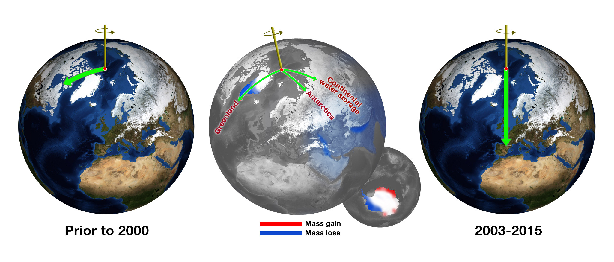
My point wasn't that the Earth doesn't wobble like a top, but that as long as the spin axis doesn't change the North Pole doesn't change its geographic position, like the Magnetic North Pole does. I think what they're saying is that the change in mass distribution due to global warming is making the Earth wobble faster than usual, and the direction is generally eastward (counterclockwise). It's interesting the diagram shows the movement going toward Canada, rather than the U.K. as the article says.
We'll be able to see the effect by looking at the position of the North Star, which wasn't in the same place in the sky when the pyramids were built, due to precession.
I was trying to post this image in my prior post:
http://www.alaskaroads.com/A4+AK3-northend-wide-large.jpg
If you stand precisely on the North Pole and take one step, the only direction you can go is south...
muriel_volestrangler
(101,355 posts)But it is about the precise location of the spin axis (as measured relative to land on the Earth's surface). You're right that every move is 'south', of course. Up to about 2000, it was moving south along, perhaps, the line of longitude at 80 degrees west; since then it's moving south roughly along the Greenwich meridian. Lower down in the article:
But this won't have anything to do with the recent quakes, of course; the whole of the earth's surface is gradually shifting together, due to the movement of water on top of it (and in it - the article says depletion of aquifers is an important part of it), so it's not about tectonic stresses. And that started about 16 years ago, not just this year.

CC
(8,039 posts)thing. Wondered if the stress would change internally because of the changes externally. Good to know I am not the only one with these questions.

Blue_In_AK
(46,436 posts)you're referring to the town of North Pole, Alaska, not THE North Pole.
LastLiberal in PalmSprings
(12,591 posts)Drat! Now you're going to tell me that wasn't the real Santa Claus I met!
Actually, when we lived in Fairbanks we went to the SCH occasionally. The first time, Santa walked over and handed my wife a lollipop. She immediately turned into a six-year-old child -- "Thank you, Santa..."
Another time we saw Santa in the play room sitting at a child-sized table with a four-year-old playing with some toy trains. As far as the kid was concerned it was no big thing, this is what Santa does. Sweet.
Blue_In_AK
(46,436 posts)but Santa Claus was elected to the North Pole city council this year. True story.
allan01
(1,950 posts)

longship
(40,416 posts)The earthquake scale is just called "magnitude" these days. It is more accurate than the older Richter scale.

bigworld
(1,807 posts)You'd think they'd be out there but heck if I can find any.
Baclava
(12,047 posts)2naSalit
(86,765 posts)It shows that there were actually 3 quakes... 7.8; 7.3; 7.9 yikes!
vkkv
(3,384 posts)
No, actually I'm quite sure.. it is click-bait.
muriel_volestrangler
(101,355 posts)and it came from a reliable source, ie the USGS.

csziggy
(34,137 posts)https://www.google.com/search?q=click+bait&ie=utf-8&oe=utf-8
The link in the OP is to the US Geological Service page for the quake report for that specific quake. There are no ads, no sensationalism, just data. Therefore that link is not by any stretch of the imagination "clik-bait."
If I remember correctly those reports are automatically generated to pass along the information from earthquake sensors. There is little or no new text about a newly detected earthquake, just the generated maps and information with historical context. So there really isn't anything to quote from that site.
Here is what the page says in part - hardly "of a sensational or provocative nature" :
The April 16, 2016 M 7.8 earthquake, offshore of the west coast of northern Ecuador, occurred as the result of shallow thrust faulting on or near the plate boundary between the Nazca and Pacific plates. At the location of the earthquake, the Nazca plate subducts eastward beneath the South America plate at a velocity of 61 mm/yr. The location and mechanism of the earthquake are consistent with slip on the primary plate boundary interface, or megathrust, between these two major plates. Subduction along the Ecuador Trench to the west of Ecuador, and the Peru-Chile Trench further south, has led to uplift of the Andes mountain range and has produced some of the largest earthquakes in the world, including the largest earthquake on record, the 1960 M 9.5 earthquake in southern Chile.
While commonly plotted as points on maps, earthquakes of this size are more appropriately described as slip over a larger fault area. Events of the size of the April 16, 2016 earthquake are typically about 160x60 km in size (length x width).
Ecuador has a history of large subduction zone related earthquakes. Seven magnitude 7 or greater earthquakes have occurred within 250 km of this event since 1900. On May 14th, 1942, a M 7.8 earthquake occurred 43 km south of this April 16th, 2016 event. On January 31st, 1906 a M 8.3 earthquake (reportedly as large as M 8.8 in some sources) nucleated on the subduction zone interface 90 km to the northeast of the April 2016 event, and ruptured over a length of approximately 400-500 km, resulting in a damaging tsunami that caused in the region of 500-1,500 fatalities. The April 2016 earthquake is at the southern end of the approximate rupture area of the 1906 event. A shallow, upper crustal M 7.2 earthquake 240 km east of the April 2016 event on March 6th, 1987 resulted in approximately 1,000 fatalities.
Lodestar
(2,388 posts)Powerful earthquake kills 77 in Ecuador'
A powerful earthquake killed at least 77 people, injured hundreds more, ravaged coastal towns and sent residents fleeing for higher ground in Ecuador on Saturday night.
The 7.8 magnitude earthquake struck off Ecuador's Pacific coast and was felt hundreds of miles (km) away in the capital of Quito as well as in the large commercial city of Guayaquil, where rubble lay strewn in the streets and some buildings were cracked or partially collapsed.
A bridge in the city collapsed on top of car, crushing it.
The earthquake was Ecuador's worst in decades and officials said the death toll was likely to rise even higher as rescue teams headed into the hardest-hit areas.
//
A state of emergency was declared in six provinces.
The areas worst affected include Pedernales, which draws tourists with beaches lined with palm-trees and tropical thatch-hut restaurants, as well as nearby Cojimies.
"There are villages that are totally devastated," Pedernales' mayor, Gabriel Alcivar, said in a radio interview. "What happened here in Pedernales is catastrophic."
more
http://www.reuters.com/article/us-ecuador-quake-idUSKCN0XE009
Video
http://www.reuters.com/video/2016/04/17/damage-in-ecuador-after-deadly-earthquak?videoId=368149890&videoChannel=1
muriel_volestrangler
(101,355 posts)Ecuador’s president Rafael Correa, returning from a summit in Italy, says the death toll from Saturday night’s quake has more than tripled since the last official announcement - now 233 people.
http://www.theguardian.com/world/live/2016/apr/17/ecuador-earthquake-death-toll-rises-latest-developments