General Discussion
Related: Editorials & Other Articles, Issue Forums, Alliance Forums, Region ForumsTropical Storm Debby has formed - Louisiana watch out
http://www.nhc.noaa.gov/storm_graphics/AT04/refresh/AL0412W5_NL_sm2+gif/205251W5_NL_sm.gifA TROPICAL STORM WARNING HAS BEEN ISSUED FROM THE MOUTH OF THE PEARL
RIVER WESTWARD TO MORGAN CITY LOUISIANA...NOT INCLUDING THE CITY OF
NEW ORLEANS OR LAKE PONTCHARTRAIN.
SUMMARY OF WATCHES AND WARNINGS IN EFFECT...
A TROPICAL STORM WARNING IS IN EFFECT FOR...
* THE COAST OF LOUISIANA FROM THE MOUTH OF THE PEARL RIVER WESTWARD
TO MORGAN CITY...NOT INCLUDING THE CITY OF NEW ORLEANS OR LAKE
PONTCHARTRAIN
A TROPICAL STORM WARNING MEANS THAT TROPICAL STORM CONDITIONS ARE
EXPECTED SOMEWHERE WITHIN THE WARNING AREA WITHIN 36 HOURS.
FOR STORM INFORMATION SPECIFIC TO YOUR AREA...INCLUDING POSSIBLE
INLAND WATCHES AND WARNINGS...PLEASE MONITOR PRODUCTS ISSUED BY
YOUR LOCAL NATIONAL WEATHER SERVICE FORECAST OFFICE.
DISCUSSION AND 48-HOUR OUTLOOK
------------------------------
AIRCRAFT RECONNAISSANCE AND BUOY DATA INDICATE THAT THE AREA OF LOW
PRESSURE IN THE GULF OF MEXICO HAS BECOME TROPICAL STORM DEBBY.
AT 400 PM CDT...2100 UTC...THE CENTER OF TROPICAL STORM DEBBY WAS
LOCATED NEAR LATITUDE 26.2 NORTH...LONGITUDE 87.6 WEST. DEBBY IS
MOVING TOWARD THE NORTH NEAR 6 MPH...9 KM/H. A SLOW NORTHWARD
MOTION IS EXPECTED TONIGHT...FOLLOWED BY A WESTWARD TURN ON SUNDAY.
ON THE FORECAST TRACK...THE CENTER OF DEBBY WILL BE MOVING OVER THE
NORTHERN GULF OF MEXICO DURING THE NEXT FEW DAYS.
MAXIMUM SUSTAINED WINDS ARE NEAR 50 MPH...85 KM/H...WITH HIGHER
GUSTS. THESE WINDS ARE OCCURRING WELL EAST OF THE CENTER OF
CIRCULATION. SOME STRENGTHENING IS FORECAST DURING THE NEXT 48
HOURS.
TROPICAL-STORM-FORCE WINDS EXTEND OUTWARD UP TO 175 MILES...280 KM
TO THE EAST OF THE CENTER.
MINIMUM CENTRAL PRESSURE ESTIMATED FROM RECONNAISSANCE DATA IS 1001
MB...29.56 INCHES.
HAZARDS AFFECTING LAND
----------------------
WIND...TROPICAL STORM CONDITIONS ARE EXPECTED TO FIRST REACH THE
COAST WITHIN THE WARNING AREA BY SUNDAY NIGHT...MAKING OUTSIDE
PREPARATIONS DIFFICULT OR DANGEROUS.
STORM SURGE...THE COMBINATION OF A STORM SURGE AND THE TIDE WILL
CAUSE NORMALLY DRY AREAS NEAR THE COAST TO BE FLOODED BY
RISING WATERS. THE WATER COULD REACH THE FOLLOWING DEPTHS ABOVE
GROUND IF THE PEAK SURGE OCCURS AT THE TIME OF HIGH TIDE...
 = new reply since forum marked as read
Highlight:
NoneDon't highlight anything
5 newestHighlight 5 most recent replies
= new reply since forum marked as read
Highlight:
NoneDon't highlight anything
5 newestHighlight 5 most recent replies
2on2u
(1,843 posts)
malaise
(269,096 posts)Give thanks

BumRushDaShow
(129,207 posts)as the 4th "named" storm for this early in the season happening in the month of June, which has never happened before.
malaise
(269,096 posts)looks like she will remain a tropical storm according to NHC's forecast.
BumRushDaShow
(129,207 posts)persistently goes into a drought (although they seem to cycle between very hot dry and then very hot wet). Last year was one of the worse droughts there on record.
This may help the area recover somewhat depending on where it makes landfall...
malaise
(269,096 posts)BumRushDaShow
(129,207 posts)Am a subscriber there. Great site!! 

Little Star
(17,055 posts)I have a daughter & sister who live in Florida and your posts make me pay attention. Thanks again, I appreciate it.
malaise
(269,096 posts)At least the Miami folks will have their HEAT parade on Monday - lots of rain in Florida this weekend. Those outer bands are delivering heavy rain in Miami. Most of the rain is on the eastern side of the storm.
Tell them to be wary of some serious lightning - my sis doesn't even want to use her phone 
susanr516
(1,425 posts)We could sure use the rain in South Texas.
We've already pruned out our dead/weak tree branches. We only have to cut away a few small branches overhanging the roof. We thought we were well ahead in the hurricane game, but we never imagined a tropical storm forming in the Gulf in June.
Hate to see what August might bring. 
malaise
(269,096 posts)so I hope you get your rain

greytdemocrat
(3,299 posts)The dogs are NOT happy!!! 
Zippo wind, just straight down heavy rain. I'm a couple miles inland from Siesta Key.
malaise
(269,096 posts)Is there thunder and lightning that's scaring the dogs?
greytdemocrat
(3,299 posts)No thunder or lightning, just rain. They don't like getting their paws wet. 

steve2470
(37,457 posts)malaise
(269,096 posts)NoPasaran
(17,291 posts)I'll leave the porch light on.

aikoaiko
(34,177 posts)[IMG]
 [/IMG]
pscot
(21,024 posts)somewhere between Brownsville and Tallahassee. Get ready.

dixiegrrrrl
(60,010 posts)Hope our corner of SW Ala. gets at least a bit of rain. It is 80 degrees outside..at 11 pm. Hot dry still air.
uggggh.
malaise
(269,096 posts)TROPICAL STORM DEBBY SPECIAL ADVISORY NUMBER 4...CORRECTED
NWS NATIONAL HURRICANE CENTER MIAMI FL AL042012
700 AM CDT SUN JUN 24 2012
CORRECTED TO MODIFY SURGE HAZARD STATEMENT...
...TROPICAL STORM WARNINGS ISSUED FOR A PORTION OF THE FLORIDA AND
ALABAMA GULF COAST...
SUMMARY OF 700 AM CDT...1200 UTC...INFORMATION
----------------------------------------------
LOCATION...27.5N 87.0W
ABOUT 170 MI...270 KM SE OF THE MOUTH OF THE MISSISSIPPI RIVER
ABOUT 195 MI...315 KM SW OF APALACHICOLA FLORIDA
MAXIMUM SUSTAINED WINDS...60 MPH...95 KM/H
PRESENT MOVEMENT...N OR 360 DEGREES AT 2 MPH...4 KM/H
MINIMUM CENTRAL PRESSURE...994 MB...29.35 INCHES
WATCHES AND WARNINGS
--------------------
CHANGES WITH THIS ADVISORY...
A TROPICAL STORM WARNING HAS BEEN ISSUED FROM THE MISSISSIPPI
ALABAMA BORDER EASTWARD TO OCHLOCKONEE RIVER FLORIDA.
SUMMARY OF WATCHES AND WARNINGS IN EFFECT...
A TROPICAL STORM WARNING IS IN EFFECT FOR...
* THE COAST OF LOUISIANA FROM THE MOUTH OF THE PEARL RIVER WESTWARD
TO MORGAN CITY...NOT INCLUDING THE CITY OF NEW ORLEANS OR LAKE
PONTCHARTRAIN
* THE MISSISSIPPI ALABAMA BORDER EASTWARD TO OCHLOCKONEE RIVER
FLORIDA.
A TROPICAL STORM WARNING MEANS THAT TROPICAL STORM CONDITIONS ARE
EXPECTED SOMEWHERE WITHIN THE WARNING AREA WITHIN 36 HOURS.
FOR STORM INFORMATION SPECIFIC TO YOUR AREA...INCLUDING POSSIBLE
INLAND WATCHES AND WARNINGS...PLEASE MONITOR PRODUCTS ISSUED BY
YOUR LOCAL NATIONAL WEATHER SERVICE FORECAST OFFICE.

Odin2005
(53,521 posts)This is gonna be a bad year.
malaise
(269,096 posts)it would have been a monster
UnrepentantLiberal
(11,700 posts)Have any major hurricanes formed in the Gulf of Mexico?
malaise
(269,096 posts)and form in either the Caribbean sea or the Gulf. There have been a few late season ones as well, I'll dig up some details for you tomorrow to answer the last part i.e. worst hurricanes.
This one began as a wave that came out of Central America into the Caribbean Sea and up into the Yucatan Penn.
UnrepentantLiberal
(11,700 posts)Looking forward to it.
malaise
(269,096 posts)Latest forecast suggests Cat1 for Texas. This is one strange storm.

juajen
(8,515 posts)malaise
(269,096 posts)
The Cat 5s
Thirty-five Category 5s have been recorded in the Atlantic basin since 1851, when records began. Only one Category 5 has been recorded in July, seven in August, twenty in September, four in October, and one in November. There have been no officially recorded June or off-season Category 5 hurricanes.[1]
The July and August Category 5s reached their high intensities in both the Gulf of Mexico and the Caribbean Sea. These are the areas most favorable for tropical cyclone development in those months.[1][10]
September sees the most Category 5 hurricanes. This coincides with the climatological peak of the Atlantic hurricane season, which occurs in early September.[11] September Category 5s reached their strengths in any of the Gulf of Mexico, Caribbean Sea, and open Atlantic. These places are where September tropical cyclones are likely to form.[10] Many of these hurricanes are either Cape Verde-type storms, which develop their strength by having a great deal of open water; or so-called Bahama busters, which intensify over the warm Loop Current in the Gulf of Mexico.[12]
All five Category 5s in October and November reached their intensities in the western Caribbean, a region that Atlantic hurricanes strongly gravitate toward late in the season.[10] This is due to the climatology of the area, which sometimes has a high-altitude anticyclone that promotes rapid intensification late in the season, as well as warm waters. Originally, there were only three Category 5s discovered in October, but reanalysis found out that a Hurricane in 1924 also reached that intensity during the month, so four Category 5s developed in October.[1]
http://en.wikipedia.org/wiki/List_of_Category_5_Atlantic_hurricanes
-----------------------
I think this article has the most information because it has graphics showing where the storms originate by month
http://en.wikipedia.org/wiki/North_Atlantic_tropical_cyclone.
There is no doubt that the worst of the storms are Atlantic hurricanes.
UnrepentantLiberal
(11,700 posts)So we know this won't be a cat 5. (We hope! )
malaise
(269,096 posts)and thet still haven't decided where Debby's going!!
UnrepentantLiberal
(11,700 posts)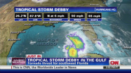
By the CNN wire staff
The outer bands of Tropical Storm Debby lashed Florida on Sunday, spawning two apparent tornadoes in the central part of the state that killed one woman, a county spokeswoman said.
Gloria Rybinski, emergency operations spokeswoman for Highland County, said the twisters destroyed four homes in the southern end of the county and damaged others.
The woman was found dead in a home in Venus, located in the middle of the state roughly between Port St. Lucie and Sarasota, Rybinski said. In addition, a child in one of the affected homes was injured and transported to a hospital for treatment.
The slowly moving center of Debby remains in the Gulf of Mexico, though it's already pounding the region with torrential rain in addition to the perilous winds.
More: http://us.cnn.com/2012/06/24/us/tropical-weather/index.html?hpt=hp_t1
malaise
(269,096 posts)and Debby is one weird storm
greytdemocrat
(3,299 posts)We have easily gotten over 7 inches, probably more. My rain guage cracked so it's useless.
Another band blowing thru right now...
malaise
(269,096 posts)