General Discussion
Related: Editorials & Other Articles, Issue Forums, Alliance Forums, Region ForumsHurricane JOAQUIN Forecast Discussion
Last edited Wed Sep 30, 2015, 12:53 PM - Edit history (1)


That track is the best guess they have so far, it surely will change, stay tuned
 = new reply since forum marked as read
Highlight:
NoneDon't highlight anything
5 newestHighlight 5 most recent replies
= new reply since forum marked as read
Highlight:
NoneDon't highlight anything
5 newestHighlight 5 most recent replies
liberal N proud
(60,346 posts)Going again next week and what do we have - Tropical Storm
Weather is usually beautiful after though as long as the damage is not great. The one in May did no damage.
Baclava
(12,047 posts)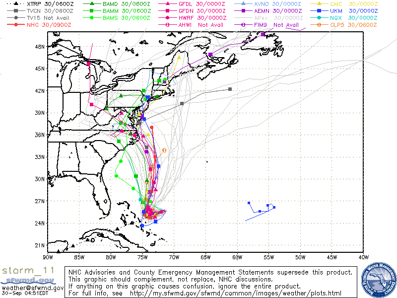

Amishman
(5,559 posts)this is the model spread as of this morning (Thursday). The 120 hour positions are spread from TN to MA to even Bermuda.

Baclava
(12,047 posts)it's the batttle of the computer models - the European model wants to send this out to sea
![]()

Nay
(12,051 posts)roots.

Oilwellian
(12,647 posts)We live on 3 acres under a canopy of great oaks. They're massive and many are next to our home. 
OnlinePoker
(5,727 posts)This should reduce coastal flooding as it comes ashore in the north east next week.
Baclava
(12,047 posts)

malaise
(269,191 posts)but suggest all pay attention - I suggest that Crispy Christie stays home
Baclava
(12,047 posts)HURRICANE JOAQUIN DISCUSSION NUMBER 11
NWS NATIONAL HURRICANE CENTER MIAMI FL AL112015
1100 AM EDT WED SEP 30 2015
There is disagreement in the track guidance between the
ECMWF and the other dynamical models. The majority of the guidance
forecasts Joaquin to turn west of north after 48-72 hours, with the
storm moving inland over the mid-Atlantic states and merging with
the trough. On the other hand, the ECMWF forecast the hurricane to
move out to sea between North America and Bermuda. The ECMWF
forecasts Joaquin to move more to the south during the first 24-48
hours than the other models. In addition, it shows the hurricane
interacting with an upper-level low to its northeast that results in
a more eastward motion after 48 hours. The new forecast track,
which is similar to the previous track, leans more toward the
non-ECMWF guidance. However, out of deference to the ECMWF, it
lies to the east of the center of the guidance envelope and the
consensus models. The NOAA G-IV jet is scheduled to fly a synoptic
surveillance mission this afternoon, which, along with special
rawinsonde launches over the eastern U. S., hopefully will reduce
the spread of the guidance.
Joaquin is expected to remain in an environment of moderate
northeasterly vertical shear for the next 24-36 hours. However,
since it has been steadily strengthening in such an environment,
there is no obvious reason to think it will stop doing so. After
36 hours, the hurricane is likely to move into an area of divergent
southerly upper-level winds associated with the eastern U. S.
trough. While there is uncertainty as to how much shear should
occur, it is expected that additional intensification could occur
through 72 hours.
Based on this, the intensity forecast calls for
Joaquin to peak as a major hurricane in about 72 hours, and it is
possible it could be stronger than currently forecast.
http://www.nhc.noaa.gov/text/refresh/MIATCDAT1+shtml/301458.shtml

JCMach1
(27,574 posts)or could still end-up a fish storm.
KittyWampus
(55,894 posts)but I'm not that knowledgable.
Baclava
(12,047 posts)Happens a lot
Baclava
(12,047 posts)Crazy
![]()
Eleanors38
(18,318 posts)This apparently happened with Andrew as it stalled and pumped up over that area before jagging westward over S. Florida.
Gloria
(17,663 posts)the stupidity of people like Rubio and Bush who say it will kill jobs to do anything about climate change? The sea around Miami is up an astounding amount and it is flooding regularly in areas...and FL is sinking...
It's going to look like Venice soon .....
Frankly, if the people of FL keep electing assholes, maybe it's "GOD's WILL"...you know, that loving GOD they always talk about....
They need to GROW UP
Baclava
(12,047 posts)SOME MODELS SHOW NEW YORK CITY AREA IS IN THE POSSIBLE PATH OF HURRICANE JOAQUIN
NEW YORK (WABC) -- Weather models show very different potential paths Hurricane Joaquin could take over the next week, with several of them now showing it head directly toward the New York City area.
http://abc7ny.com/weather/tracking-joaquin-nyc-is-in-the-possible-path-of-hurricane/1007792/
malaise
(269,191 posts)lots of water coming for sure
Gloria
(17,663 posts)Used to live at the Jersey shore...remember the bulkhead in back of the house I shared with my friend on the Shark River, a block from the beach, on 1st Ave. in Belmar.....Scary if that had gone!!! It needed repairs, don't know if her parents, who owned the house, ever fixed it!! Was a $10,000 plus repair back in the mid-70's!
Baclava
(12,047 posts)ayep - stay safe
Eleanors38
(18,318 posts)trumad
(41,692 posts)1939
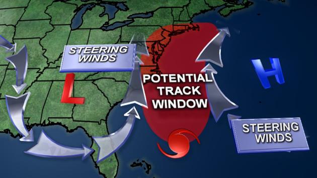
(1,683 posts)I believe that accounts for the general model consensus that has the storm is going to make a sharp right turn and begin moving north. Where it will come ashore is still an unknown. They think anywhere from Hatteras to New England.
Some years back, the Carolinas were ground zero for hurricanes.
Baclava
(12,047 posts)
According to Mike Smith, senior vice president and chief innovation executive of AccuWeather Enterprise Solutions, "There is going to be catastrophic flooding from North Carolina to Massachusetts, and this is going to disrupt the economy regardless of whether or not Hurricane Joaquin makes landfall."
No matter how similar the pattern may seem, no two storms are ever exactly alike. The same can be said about the situation developing this weekend along the Atlantic coast with the approach of Joaquin.

Satellite: Side-by-side photos of Sandy (left) on Oct. 28, 2012, and Isabel (right) on Sept. 18, 2003. (MODIS Rapid Response Team NASA/GSFC)
http://www.accuweather.com/en/weather-news/how-will-joaquin-compare-to-superstorm-sandy-hurricane-isabelle-east-coast-impact-new-jersey-north-carolina/52693970
Lee-Lee
(6,324 posts)And I am not even in the storm track, they are saying the storm will stall a front over us.
It's already wet- this will be a disaster.
malaise
(269,191 posts)Stay safe 
Baclava
(12,047 posts)
malaise
(269,191 posts)It's a very big storm.
Spare a thought for folks in the Bahamas
Damn it's going to be Cat 3
![]()
Baclava
(12,047 posts)It's not that big of a storm, size wise, but it's spinning up quickly. Could catch some by surprise.
malaise
(269,191 posts)It is going to be a Cat3 but mostly over water.
Baclava
(12,047 posts)If I was in Miami, I'd be watching closely.
malaise
(269,191 posts)The Bahamas will face a Cat 2
Baclava
(12,047 posts)Long range, anyway
malaise
(269,191 posts)Bahamas.
Could be Cat 4 later today but will weaken before and if it hits mainland USA.
Stay safe folks.
Baclava
(12,047 posts)
KG
(28,753 posts)Baclava
(12,047 posts)May the gods and goddesses continue to smile upon you.
yep
beveeheart
(1,371 posts)and Rehoboth Beach,DE during this coming weekend. I was in Rehobeth a few years ago when Isabel passed by. Wasn't so bad there, but did do a lot of damage in Rock Hall, MD just a few miles from where I went after Rehoboth.
Stay safe, East Coasters!

Marrah_G
(28,581 posts)I can't afford to lose power for too long.
Baclava
(12,047 posts)The rain will still be there though. Or so they say.

Warpy
(111,359 posts)NOAA is forecasting it sitting on the Bahamas for a couple of days, grazing Hatteras, and then going right up Chesapeake Bay. It'll be a tropical storm by the time it gets of DC but they can bet on a lot of flooding.
Then again, it's 5 days out, a lot is likely to change by then.
Baclava
(12,047 posts)#Joaquin is a powerful Category 3 storm, but could strengthen more, forecasters say.
Maximum sustained winds are near 120 mph (195 km/h) with higher
gusts. Joaquin is a category 3 hurricane on the Saffir-Simpson
Hurricane Wind Scale. Some strengthening is forecast in the next
day or so, with some fluctuations in intensity possible on Friday.
Hurricane force winds extend outward up to 35 miles (55 km) from the
center and tropical storm force winds extend outward up to 140 miles
(220 km)
http://www.nhc.noaa.gov/text/refresh/MIATCPAT1+shtml/302357.shtml

leftyladyfrommo
(18,874 posts)I'll take our tornadoes any time over these hurricanes
Baclava
(12,047 posts)Not me. You can see a cane coming for days and decide on your own to get out of the way.
and it probably won't hit NYC, although some rain could
leftyladyfrommo
(18,874 posts)I did have one go over my house at 2 in the morning and it is a really incredible noise. And a couple have put down fairly close to me but the damage was limited. A couple or houses got hit. But tornado storms come through really fast. They hit a very limited area. Hurricanes last for hours and the devastation can be enormous.
The huge tornadoes like the one that hit Joplin are so rare. And they are terrible. But they just don't compare to what a huge hurricane can do with sustained winds of 120 miles an hour for hours and hours.
Baclava
(12,047 posts)I've been in a few of those howling Cat 3's - anything bigger coming and I leave and come back when the power returns.
You make your own risk assessments with canes. Storm surge is not something I have to deal with. A tornado that sweeps your home off down to the slab is not something I would want to be around.
but back to the topic, until it turns north, it's really all just a guess
let's hope it goes to swim with the fishes