General Discussion
Related: Editorials & Other Articles, Issue Forums, Alliance Forums, Region ForumsRude Pundit:Photos That Make the Rude Pundit Want to Down a Handful of Ativan ...
With a Six Pack of Abita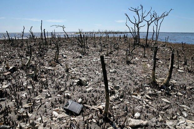
That up there is Cat Island in Louisiana, in a photo from a week ago, which is nearly four years after the Deepwater Horizon ejaculated oil all over the Gulf coast. It used to be a nesting ground for brown pelicans, a lush mangrove-covered island that looks, as Doug Meffert, Vice President of the of the National Audubon Society, said, as if there was a fire. There wasn't a fire.
Sure, there are areas of that have recovered from the spill that started in April, some mitigation by time, water temperature, natural bacteria. Indeed, some of the recovery has surprised scientists.
Of course, there's no telling what's going to happen in the future as the environment continues to adapt to its poisoning by the oil and by the chemicals used to clean up the oil. An environmental chemist at LSU said, "
 T)he oil is still in the marsh and it stays buried there, and every time there’s a storm event, tropical storms, it’s going to move some of that oil that’s still in the offshore environment around, and it will resurface." Another scientist says that they're still not sure where a third of the oil is.
We should also take into account the studies that link the oil spill with heart deformities in big fish like tuna and amberjack, ones that, you know, are immensely profitable, overfished already in some areas, now fucked right in their guts. "We can now say with certainty that oil causes cardiotoxicity in fish," says another scientist. Of course, we know what science is worth when it comes to the environment in the United States on this Earth Day 2014.
It really is like BP squatted down just squatted down over the Gulf of Mexico and squirted out the kind of watery shits that you get after drinking a bottle of cheap whiskey and eating a ton of fried food, laughing at how huge a dump it was taking and merely saying, "Whoa, that stinks" when it was done. But at least it wiped, right?
Back on Cat Island, there's one other effect of the decimation of the vegetation there. See, the roots of the mangrove trees held the soil together and, without them, the island is eroding away quickly, destroying not just the nesting grounds of the pelicans, but a buffer between the mainland and storms, and, well, hell, probably oil spills, too.
By the way, here's what Cat Island looked like in July 2010, a couple of months after the spill began, but before the oil had had an impact, during that gut-wrenching period of wondering where it was going to hit.
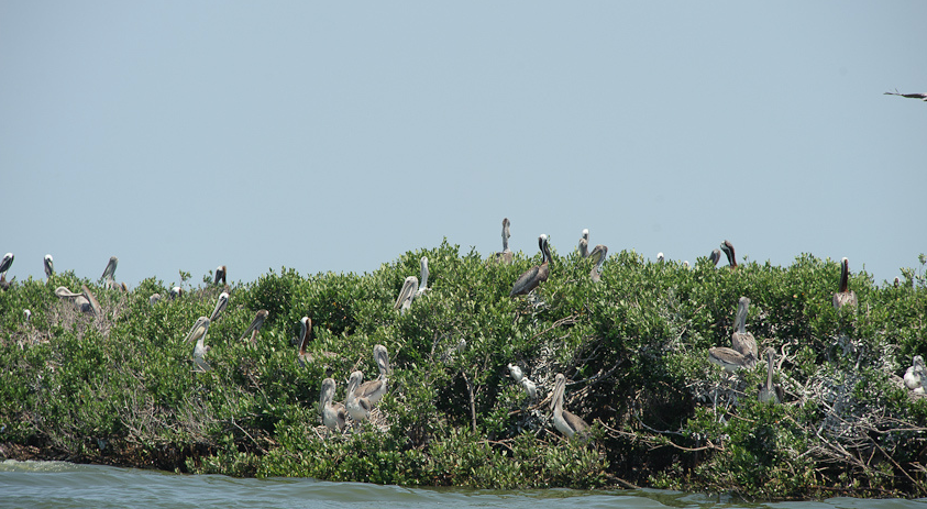
Pretty isn't it? It's nice that we have photos to remember it by.
http://rudepundit.blogspot.com/2014/04/photos-that-make-rude-pundit-want-to.html
 = new reply since forum marked as read
Highlight:
NoneDon't highlight anything
5 newestHighlight 5 most recent replies
= new reply since forum marked as read
Highlight:
NoneDon't highlight anything
5 newestHighlight 5 most recent replies
Spitfire of ATJ
(32,723 posts)Nope. The Republicans licked it clean.

caraher
(6,279 posts)A July-July comparison would be even more powerful.
It's hard to overestimate the scope of the disaster - my hunch is that the worst effects will emerge over time and be less visible than this already stark comparison...

csziggy
(34,136 posts)From CONSERVATION HABITATS & SPECIES ASSESSMENTS LA CWCS--DEC 2005:
Although sometimes termed a swamp, the physiognomy of the community in Louisiana more closely resembles a shrub thicket. The coastal region of Louisiana delimits the northern range of this community due to mangrove's inability to tolerate temperatures below freezing. The top-kill caused by winter freezes also limits mangroves to a shrub-like form (10 feet or less in height), unlike Florida where they attain forest stature.
<SNIP>
Current Extent and Status:
Mangroves in Louisiana are found along the fringes of the Deltaic Plain coastal marshes most
commonly flanking large bays and on the leeward side of barrier islands. Montz (1980)
estimated that in the late 1970’s a total of 3,900 to 5,900 acres of mangroves occurred in Louisiana. Hard freezes in the winters of 1983 and 1984 seriously reduced the extent of this community in coastal Louisiana. The mangrove swamps importance in erosion control was clearly documented by the extreme erosion of Queen Bess Island following the 1983-84 dieback, and today mangrove is often used for marsh stabilization in coastal restoration projects. Mild winters of the past decade have allowed expansion of this natural community in
southeastern Louisiana’s coastal marshes.
http://www.wlf.louisiana.gov/sites/default/files/pdf/document/32868-coastal-mangrove-marsh-shrubland/coastal_mangrove-marsh_shrubland.pdf
This early in the year it's hard to tell if cold damaged plants would recover. If the roots were already stressed by the oil and oil containment chemicals, the second blow of a very cold winter could kill off the mangrove communities along the Louisiana coast.
I wonder what those same places looked like last fall before the winter?
Edited to add: Looking at the photos from the original article (http://www.nola.com/environment/index.ssf/2014/04/bp_oil_spill_scientists_strugg.html#incart_river), the destruction of the mangroves is far more extensive than a simple one year freeze event. All of the twig branches are gone, there are no remanent leaves, a lot of the main trunks are gone.

localroger
(3,629 posts)Offshore islands are well buffered against blasts of cold arctic air because of all that Gulf water surrounding them. Even if you had a few susceptible species, you would not get this degree of defoliation because some of the grasses are evergreen. This landscape was poisoned.
Clearly it's a mess even without a cold winter!

tosh
(4,424 posts)The northern gulf is fully leafed out and as green as it gets right now.
I'm from further north so brown in spring doesn't really set off as many alarm bells! And even if it were green it's still poisoned!

daleanime
(17,796 posts)
BlancheSplanchnik
(20,219 posts)
libodem
(19,288 posts)And recommend.
DeSwiss
(27,137 posts) - Obama promised to make BP pay. So BP will probably take care of the Brown Pelicans just as soon as Tony gets his life completely back.....
K&R
rhett o rick
(55,981 posts)