Welcome to DU!
The truly grassroots left-of-center political community where regular people, not algorithms, drive the discussions and set the standards.
Join the community:
Create a free account
Support DU (and get rid of ads!):
Become a Star Member
Latest Breaking News
General Discussion
The DU Lounge
All Forums
Issue Forums
Culture Forums
Alliance Forums
Region Forums
Support Forums
Help & Search
General Discussion
Related: Editorials & Other Articles, Issue Forums, Alliance Forums, Region Forums170 Years of the Worlds Hurricane Tracks on One Dark and Stormy Map
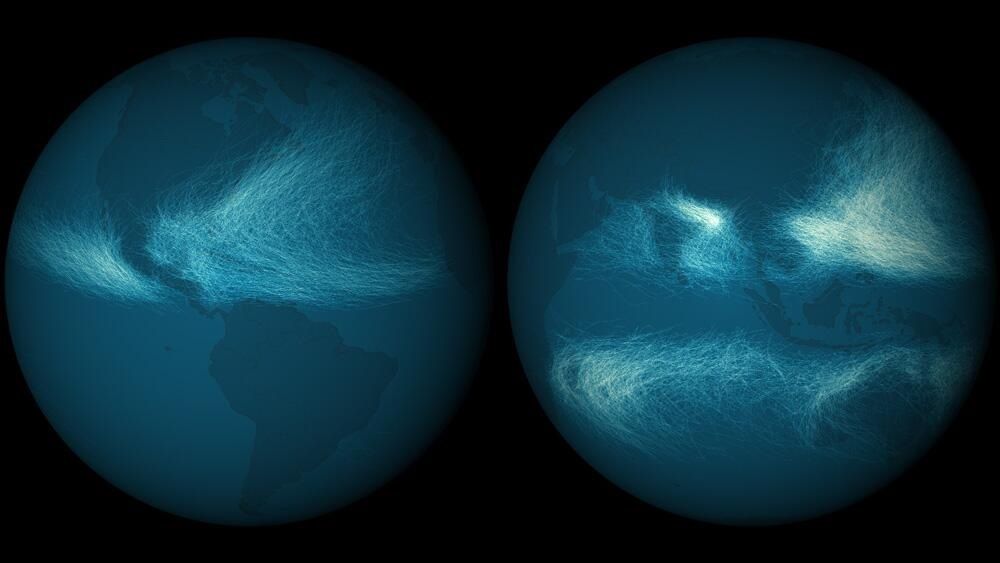

This map shows the paths of every hurricane and cyclone detected since 1842. Nearly 12,000 tropical cyclones have been tracked and recorded, and the National Oceanic and Atmospheric Administration keeps them all in a single database. Long-term datasets can be really interesting and scientifically valuable, and this one is undoubtedly both.
In the image above, you can clearly see that more storm tracks have overlapped in the western Pacific ocean and northern Indian ocean. This is largely because of the length of the typhoon season, which basically never stops in the warmer waters there.
The tracks of the earliest storms are based on mariner’s logs and storm records, collected from various countries, agencies and other sources. Reconciling data from these different entities was tough. Most international agencies had their own set of codes for cyclone intensity, and only recorded this information once per day. India was even using different wind thresholds to designate cyclone stages.
Somehow, NOAA’s National Climatic Data Center managed to wrangle all these various reports. Originally, at the dawn of the mainframe computer age, much of this data was stored in the form of decks of punch cards, sometimes with just one position and intensity measurement for one storm recorded on each card. Later systems used 80-column cards to boost this to four measurements per card. A similar tracking system is still in use today, of course without the physical cards.
<snip>
http://www.wired.com/wiredscience/2013/08/hurricane-tracks/
Great map!
InfoView thread info, including edit history
TrashPut this thread in your Trash Can (My DU » Trash Can)
BookmarkAdd this thread to your Bookmarks (My DU » Bookmarks)
4 replies, 1520 views
ShareGet links to this post and/or share on social media
AlertAlert this post for a rule violation
PowersThere are no powers you can use on this post
EditCannot edit other people's posts
ReplyReply to this post
EditCannot edit other people's posts
Rec (16)
ReplyReply to this post
4 replies
 = new reply since forum marked as read
Highlight:
NoneDon't highlight anything
5 newestHighlight 5 most recent replies
= new reply since forum marked as read
Highlight:
NoneDon't highlight anything
5 newestHighlight 5 most recent replies
= new reply since forum marked as read
Highlight:
NoneDon't highlight anything
5 newestHighlight 5 most recent replies
170 Years of the Worlds Hurricane Tracks on One Dark and Stormy Map (Original Post)
Are_grits_groceries
Sep 2013
OP

oldandhappy
(6,719 posts)1. This is fascinating.
Thank you. I like this kind of information.

nolabear
(41,963 posts)2. Eerily beautiful.
Thanks.

burrowowl
(17,641 posts)3. Be interesting
to see how climate change will shift the patterns.

dmr
(28,347 posts)4. Fasinating
The one on the right kinda looks like the Cookie Monster on a bad day.
Seriously, though, thanks for posting this, and as the article says: "Long-term datasets can be really interesting and scientifically valuable, and this one is undoubtedly both."
