Welcome to DU!
The truly grassroots left-of-center political community where regular people, not algorithms, drive the discussions and set the standards.
Join the community:
Create a free account
Support DU (and get rid of ads!):
Become a Star Member
Latest Breaking News
General Discussion
The DU Lounge
All Forums
Issue Forums
Culture Forums
Alliance Forums
Region Forums
Support Forums
Help & Search
General Discussion
Related: Editorials & Other Articles, Issue Forums, Alliance Forums, Region ForumsNASA'S picture of the day (stunning)
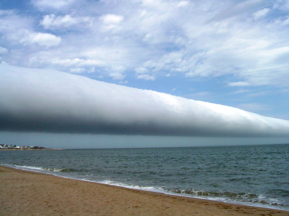
Roll Cloud Over Uruguay
Explanation: What kind of cloud is this? A roll cloud. These rare long clouds may form near advancing cold fronts. In particular, a downdraft from an advancing storm front can cause moist warm air to rise, cool below its dew point, and so form a cloud. When this happens uniformly along an extended front, a roll cloud may form. Roll clouds may actually have air circulating along the long horizontal axis of the cloud. A roll cloud is not thought to be able to morph into a tornado. Unlike a similar shelf cloud, a roll cloud, a type of Arcus cloud, is completely detached from their parent cumulonimbus cloud. Pictured above, a roll cloud extends far into the distance in 2009 January above Las Olas Beach in Maldonado, Uruguay.
InfoView thread info, including edit history
TrashPut this thread in your Trash Can (My DU » Trash Can)
BookmarkAdd this thread to your Bookmarks (My DU » Bookmarks)
10 replies, 5644 views
ShareGet links to this post and/or share on social media
AlertAlert this post for a rule violation
PowersThere are no powers you can use on this post
EditCannot edit other people's posts
ReplyReply to this post
EditCannot edit other people's posts
Rec (53)
ReplyReply to this post
10 replies
 = new reply since forum marked as read
Highlight:
NoneDon't highlight anything
5 newestHighlight 5 most recent replies
= new reply since forum marked as read
Highlight:
NoneDon't highlight anything
5 newestHighlight 5 most recent replies
= new reply since forum marked as read
Highlight:
NoneDon't highlight anything
5 newestHighlight 5 most recent replies
NASA'S picture of the day (stunning) (Original Post)
Playinghardball
Jun 2013
OP

niyad
(113,508 posts)1. beautiful--thank you for posting.

petronius
(26,603 posts)2. Very cool; thanks for posting! (nt)


SidDithers
(44,228 posts)3. Very cool...
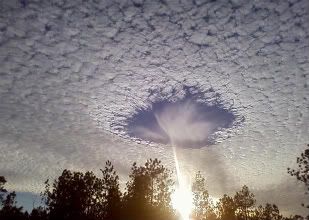
another interesting one is a hole-punch cloud, formed when some freaky things happen with ice crystals and condensation.
Sid

Benton D Struckcheon
(2,347 posts)4. Wow.
That is seriously weird. I'd be diving into the basement with my tin hat on if I saw that.
Aerows
(39,961 posts)5. Gorgeous
Beautiful beach.

Curmudgeoness
(18,219 posts)6. Seeing that would be unsettling.
It is beautiful, but it is something that I would have no idea what was coming.
L0oniX
(31,493 posts)7. Chem trail?


cyberswede
(26,117 posts)8. I saw one once on my way to work.
It was fascinating - I called people to ask if they could see it, too. When I got to work, people were buzzing about it.
The coolest thing was seeing it from different angles as I drove the 15 miles to work. It started out in front if me, and as my position moved (as well as the cloud's, I presume) it was above me, and then behind me. It was remarkable. I wish I'd had a camera.

The Straight Story
(48,121 posts)9. Looks like a giant joint

midnight
(26,624 posts)10. K&R