General Discussion
Related: Editorials & Other Articles, Issue Forums, Alliance Forums, Region ForumsInteractive Map of the United States Has One Dot for Every Human
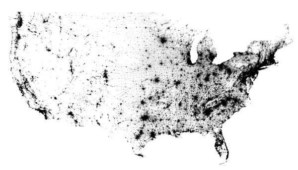
This is a map of every person counted by the 2010 US Census. The map has 308,450,225 dots - one for each person.

http://bmander.com/dotmap/index.html
liberal N proud
(60,338 posts)
muriel_volestrangler
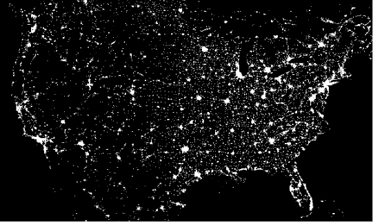
(101,330 posts)and not 'one dot for each person' at all. They look identical in shape, and have features like a lot of lines running north/south and east/west in the mid-west - probably lit highways.
On edit: maybe I'm just being too cynical. There are one or two areas where there may be a difference - what I think is Minneapolis, for example. But the overall correspondence looks surprisingly close.
pokerfan
(27,677 posts)one will find a pan and zoom map that lets one find their own dot. According to the last census, of course.
Aerows
(39,961 posts)with a Python script from block level census data.
aptal
(304 posts)RKP5637
(67,111 posts)underpants
(182,848 posts)Get your own.
LOL at your post
RKP5637
(67,111 posts)a11ig8r
(40 posts)I'm guessing northern transplants sick of cold and snow, they didn't move to the deep south because they still have family up north.
Jim Lane
(11,175 posts)Most retirees from the North wouldn't be attracted to that largely rural stretch of the South. There are a few exceptions, such as the university town of Chapel Hill, North Carolina, where a fair number of people do retire, but overall that area isn't culturally congenial to most Northerners. They're more likely to end up in southern Florida. Even if, as you point out, it's farther from people they know back North, a slightly longer or more expensive flight isn't that big a deal.
Here's my guess: That belt is roughly where the coastline was during the Cretaceous period, about a hundred million years ago. The coastal area was conducive to the growth of plankton. When the Earth cooled and the waters receded, the dead plankton left behind soil that was good for growing cotton. As a result, there were more slaves there, and their descendants still live there.
This sounds like lunacy but check out the science behind it: "How presidential elections are impacted by a 100 million year old coastline". According to the maps assembled by Dr. Craig McClain, the Assistant Director of Science for the National Evolutionary Synthesis Center, that stretch is where the Cretaceous coastline was, it's where cotton production was high in 1859, it's where there's a significant black population, and it's where you find a lot of red-state counties that nevertheless went blue in 2008. (The map for 2012 is similar.)
Based on this, I'll guess that population is higher there because of the land's suitability for cotton, with most (though of course not all) of the higher population being the descendants of slaves.
a11ig8r
(40 posts)The earth is red clay. It's the remains of a long ago mountain chain. I don't think it's the black population that is flourishing there because that has been there since colonial times. A lot of retirees gave up the sun and palm trees dreams when they figured they could save a lot of money by buying a piece of land in a rural area, again that's my guess.
underpants
(182,848 posts)Thanks for the info. I don't know that it is conclusive on first read but it sure is interesting.
I get some much great information here. Thanks Jim Lane.
Jim Lane
(11,175 posts)I first read about this hypothesis in a post on DU soon after the election. I wouldn't have caught it anywhere else.
slackmaster
(60,567 posts)
ohheckyeah
(9,314 posts)
Rex
(65,616 posts).
AZ Progressive
(3,411 posts)It is so remote going between cities in the west (except California), while in the east, you frequently pass by town after town between cities, and there's just a whole lot more cities.
madinmaryland
(64,933 posts)Aerows
(39,961 posts)That poor kitty is going crazy trying to catch it!
RandiFan1290
(6,239 posts)OK stop dots
Response to pokerfan (Original post)
Bad_Ronald This message was self-deleted by its author.
Dirty Socialist
(3,252 posts)I think I see him in Manhattan.![]()
Brigid
(17,621 posts)I seriously can identify Indy on both maps. Cool. ![]()