General Discussion
Related: Editorials & Other Articles, Issue Forums, Alliance Forums, Region Forums40 Years Ago Today; Mount St Helens erupts, killing Harry Truman (and others)
On May 18, 1980, a major volcanic eruption occurred at Mount St. Helens, a volcano located in Skamania County, in the U.S. state of Washington. The eruption (a VEI 5 event) was the most significant volcanic eruption to occur in the contiguous 48 U.S. states since the much smaller 1915 eruption of Lassen Peak in California. It has often been declared the most disastrous volcanic eruption in U.S. history. The eruption was preceded by a two-month series of earthquakes and steam-venting episodes, caused by an injection of magma at shallow depth below the volcano that created a large bulge and a fracture system on the mountain's north slope.
An earthquake at 8:32:17 a.m. PDT (UTC?7) on Sunday, May 18, 1980, caused the entire weakened north face to slide away, creating the largest landslide ever recorded. This allowed the partly molten, high-pressure gas- and steam-rich rock in the volcano to suddenly explode northwards toward Spirit Lake in a hot mix of lava and pulverized older rock, overtaking the avalanching face.
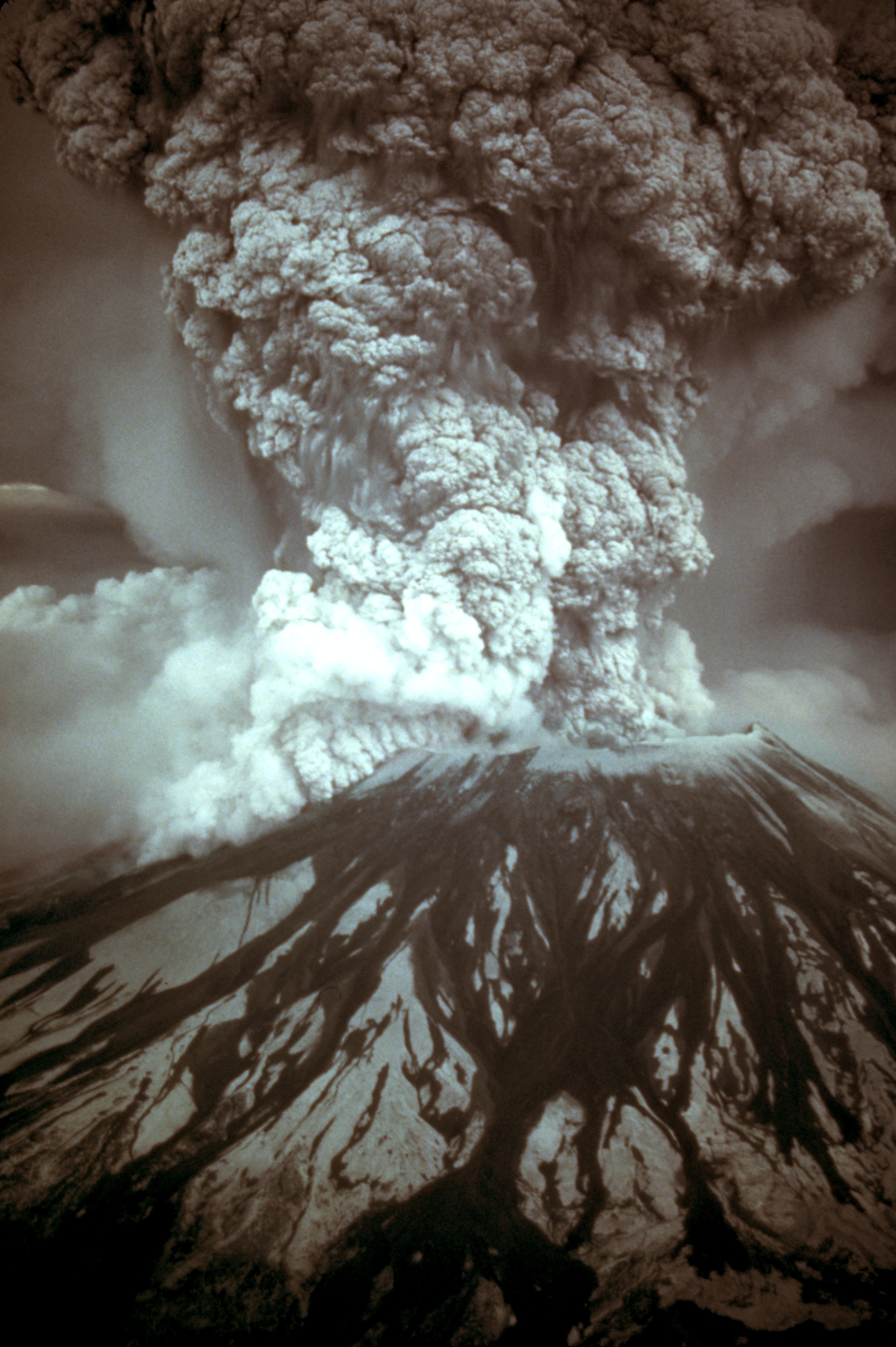
An eruption column rose 80,000 feet (24 km; 15 mi) into the atmosphere and deposited ash in 11 U.S. states and significant ash in two Canadian provinces. At the same time, snow, ice and several entire glaciers on the volcano melted, forming a series of large lahars (volcanic mudslides) that reached as far as the Columbia River, nearly 50 miles (80 km) to the southwest. Less severe outbursts continued into the next day, only to be followed by other large, but not as destructive, eruptions later that year. Thermal energy released during the eruption was equal to 26 megatons.
Approximately 57 people were killed directly, including innkeeper Harry R. Truman, photographers Reid Blackburn and Robert Landsburg, and geologist David A. Johnston. Hundreds of square miles were reduced to wasteland, causing over $1 billion in damage (equivalent to $3.3 billion today), thousands of animals were killed, and Mount St. Helens was left with a crater on its north side. At the time of the eruption, the summit of the volcano was owned by the Burlington Northern Railroad, but afterward the land passed to the United States Forest Service. The area was later preserved, as it was, in the Mount St. Helens National Volcanic Monument.
<snip>
As May 18 dawned, Mount St. Helens' activity did not show any change from the pattern of the preceding month. The rate of bulge movement, sulfur dioxide emission, and ground temperature readings did not reveal any changes indicating a catastrophic eruption. USGS volcanologist David A. Johnston was on duty at an observation post approximately six miles (10 km) north of the volcano: as of 6:00 a.m., Johnston's measurements did not indicate any unusual activity.
At 8:32 a.m., a magnitude 5.1 earthquake centered directly below the north slope triggered that part of the volcano to slide, approximately 7–20 seconds after the shock. The landslide, the largest in recorded history, travelled at 110 to 155 miles per hour (177 to 249 km/h) and moved across Spirit Lake's west arm. Part of it hit a 1,150-foot-high (350 m) ridge about six miles (10 km) north. Some of the slide spilled over the ridge, but most of it moved 13 miles (21 km) down the North Fork Toutle River, filling its valley up to 600 feet (180 m) deep with avalanche debris. An area of about 24 square miles (62 km2) was covered, and the total volume of the deposit was about 0.7 cubic miles (2.9 km3).
Scientists were able to reconstruct the motion of the landslide from a series of rapid photographs by Gary Rosenquist, who was camping 11 miles (18 km) away from the blast. Rosenquist, his party and his photographs survived because the blast was deflected by local topography one mile (1.6 km) short of his location.
Most of St. Helens' former north side became a rubble deposit 17 miles (27 km) long, averaging 150 feet (46 m) thick; the slide was thickest at one mile (1.6 km) below Spirit Lake and thinnest at its western margin. The landslide temporarily displaced the waters of Spirit lake to the ridge north of the lake, in a giant wave approximately 600 feet (180 m) high. This in turn created a 295 feet (90 m) avalanche of debris consisting of the returning waters and thousands of uprooted trees and stumps. Some of these remained intact with roots, but most had been sheared off at the stump seconds earlier by the blast of super-heated volcanic gas and ash that had immediately followed and overtook the initial landslide. The debris was transported along with the water as it returned to its basin, raising the surface level of Spirit Lake by about 200 ft (61 m).
More than three decades after the eruption, floating log mats persist on Spirit Lake and nearby St. Helens Lake, changing position with the wind. The rest of the trees, especially those that were not completely detached from their roots, were turned upright by their own weight and became waterlogged, sinking into the muddy sediments at the bottom where they have become petrified in the anaerobic and mineral-rich waters. This provides insight into other sites with a similar fossil record.
</snip>

 = new reply since forum marked as read
Highlight:
NoneDon't highlight anything
5 newestHighlight 5 most recent replies
= new reply since forum marked as read
Highlight:
NoneDon't highlight anything
5 newestHighlight 5 most recent replies

Mike 03
(16,616 posts)Whoa, I was worried for a second that my history knowledge had a serious deficiency. A different Harry Truman.

Dennis Donovan
(18,770 posts)

Mike 03
(16,616 posts)I felt very ignorant there for a second.

Jamastiene
(38,187 posts)go read the Wiki article that mentions the other Harry Truman. Good job. Good teachers do that kind of stuff too, I have noticed.

IronLionZion
(45,523 posts)as in how did I miss that fact 

panader0
(25,816 posts)I contracted tree thinning from the Forest Service in Oregon. From our units, just
south of the Columbia River near Mt. Hood, I could see Mt. St. Helens in Washington.
This was before the eruption. It was quite striking, as are much of the Cascades.
I'm glad I wasn't around for the eruption.

central scrutinizer
(11,661 posts)That morning. That’s on the slopes of Mt. Hood. We couldn’t see St. Helens from our unit but heard the blast. Then the Forest Service radios started squawking. We crummied up and got out of there before the ash could clog the engine. The fall of 1979 we planted right below St. Helens in the Gifford Pinchot NF and saw several small steam and ash releases. The year after the blast we worked a bunch of units in the blast zone that been salvage logged. Everything was covered in a thick layer of almost weightless pumice. It was like trying to dig a hole in a giant bowl of popcorn. The ground was bone dry and hot to the touch from the sun. Those seedlings were dead before we left the unit. There was a blasted car surrounded by a fence on one of the landings. It was being preserved as a historical artifact. The people inside were probably incinerated.
panader0
(25,816 posts)from cutting so many trees. Of course the thinning I did helped the remaining trees grow much faster,
but that only served to help the big lumber companies. A beautiful area isn't it? When I had a few bucks
I'd go have a beer at the Timberline Lodge on Mt. Hood.
central scrutinizer
(11,661 posts)During the summers if money was low. Didn’t like it much-too hot, yellow jackets, poison oak.
whistler162
(11,155 posts)and it turns out so was a co-worker. My brother has/had a few containers of ash from the eruption.

Siwsan
(26,289 posts)I can so clearly remember sitting in the lab, in shock, discussing this with other instructors. It's just one of those frozen in time memories.

Alacritous Crier
(3,818 posts)
rgbecker
(4,834 posts)We started seeing white ash on everything...looked like snow...even as far east as Idaho. Couldn't figure out what is was at first, the eruption was out of the news by September. The ash got thicker and thicker, 2 inches and drifts here and there. Filled a film container with it as a souvenir. It's somewhere around here, with all the other stuff.
Codeine
(25,586 posts)full of the stuff somewhere.
dalton99a
(81,570 posts)


Liberal In Texas
(13,574 posts)Disobeyed orders and became a media darling in the month before the mountain blew up. Killing him and others instantly.
Nay
(12,051 posts)deal with, for weeks.
OnlinePoker
(5,725 posts)People were selling souvenir vials of ash for $10 a pop. You could scoop as much as you wanted from the side of the road but rubes were buying these "Certified" ash packages.

Wawannabe
(5,677 posts)When this happened. I visited the area in summer 2018 on a motorcycle tour. Still devastated some 40 yrs later.
cbdo2007
(9,213 posts)everything was still covered in ash (yep, I've still got a big ziplock full of it somewhere) and abandoned vehicles still all over the place. It was an amazing place to witness. About 7 years later hiked down over the mudslide area before stuff had grown back and they were still testing the soil. Can't wait to take my kids there someday and hopefully hike up to the crater rim!
BobTheSubgenius
(11,564 posts)and the explosion woke us. At a distance of roughly 200 miles, that is one hell of an explosion.

utopian
(1,093 posts)It was a beautiful day in Vancouver, Washington. I was driving East on Fourth Plain, when I looked to the left and, Holy Shit! The mountain had just blown. I pulled over and stood there watching. We knew it was coming, but the eruption was much more dramatic than anyone I knew expected.
tavernier
(12,398 posts)For several days our skies were gritty, almost like looking through a film of some thing lightly grey. Spooky.