General Discussion
Related: Editorials & Other Articles, Issue Forums, Alliance Forums, Region ForumsOh HELL NO! TROPICAL DEPRESSION FOURTEEN
It will be a Hurricane in the Gulf by 1 am Wednesday.

https://www.nhc.noaa.gov/graphics_at4.shtml?cone#contents

 = new reply since forum marked as read
Highlight:
NoneDon't highlight anything
5 newestHighlight 5 most recent replies
= new reply since forum marked as read
Highlight:
NoneDon't highlight anything
5 newestHighlight 5 most recent replies

malaise
(269,004 posts)Looks like more flooding for the Carolinas.
https://www.nhc.noaa.gov/refresh/graphics_at4+shtml/085347.shtml?cone#contents
![]()
SUMMARY OF 400 AM CDT...0900 UTC...INFORMATION
----------------------------------------------
LOCATION...18.6N 86.9W
ABOUT 90 MI...150 KM E OF CHETUMAL MEXICO
ABOUT 260 MI...420 KM SSW OF THE WESTERN TIP OF CUBA
MAXIMUM SUSTAINED WINDS...35 MPH...55 KM/H
PRESENT MOVEMENT...NNW OR 340 DEGREES AT 3 MPH...6 KM/H
MINIMUM CENTRAL PRESSURE...1004 MB...29.65 INCHES
WATCHES AND WARNINGS
--------------------
CHANGES WITH THIS ADVISORY:
The government of Mexico has upgraded the Tropical Storm Watch from
Tulum to Cabo Catoche to a Tropical Storm Warning.
SUMMARY OF WATCHES AND WARNINGS IN EFFECT:
A Tropical Storm Warning is in effect for...
* The Cuban provinces of Pinar del Rio and the Isle of Youth
* The coast of Mexico from Tulum to Cabo Catoche
A Tropical Storm Warning means that tropical storm conditions are
expected somewhere within the warning area, in this case within 24
hours.
Interests along the northeastern and central U.S. Gulf coast should
monitor the progress of the depression.

PearliePoo2
(7,768 posts)This is awful!

With all the standing water, have you heard about the swarms of giant mosquitoes that have infested the Carolinas?
They are the size of nickels and are biting the shit out of every living thing?


dixiegrrrrl
(60,010 posts)But things can change, as we all know.
Sitting here looking out the window I see a classic Oct. day...leaves still falling, clear blue skies, long shadows of the early afternoon
but the temp is 89 degrees.
Was really hoping we could could close out the season without any more drama.
malaise
(269,004 posts)and Grits in SC. 

trueblue2007
(17,218 posts)
peekaloo
(22,977 posts)I was looking forward to a possible rainmaker because it's been hot as hell in Florida (more so than usual) but not this shite!
My relatives in NC still haven't recovered and do not need more rain should this thang venture their way.

DrDan
(20,411 posts)don't disregard this one - it will be at least a 10-inch rainmaker
All our reservoirs and dams are filling up. Our drought is over and we didn't have any wind, just on and off rain for days with more coming for another few days.
Baclava
(12,047 posts)Last edited Sun Oct 7, 2018, 09:28 AM - Edit history (1)

Maximum sustained winds are near 35 mph with higher gusts. Some strengthening is forecast during the next several days, with the depression expected to become a tropical storm later today. The system could become a hurricane by Tuesday night or Wednesday.
As future Tropical Storm Michael moves into the Gulf of Mexico, wind shear will relax somewhat and that, combined with very warm waters in the Gulf, will allow strengthening.
Given that this system is in its early stages, there is a large spread in computer model solutions in both track and intensity. Mostly because the models have all initialized with different starting points. Over the next 12 to 24 hours, more consistency in the models will come into play.
This is a much different scenario than Florence for the Carolinas a few weeks back. This system will be moving very quickly, it won’t be as large or strong.
http://www.baynews9.com/fl/tampa/weather/2018/10/07/tropical-depression-could-form-by-late-this-weekend
DrDan
(20,411 posts)Baclava
(12,047 posts)
DrDan
(20,411 posts)the gulf is a bathtub right now - pushing 90 degrees
but thanks for the edit - your post is more accurate now
Baclava
(12,047 posts)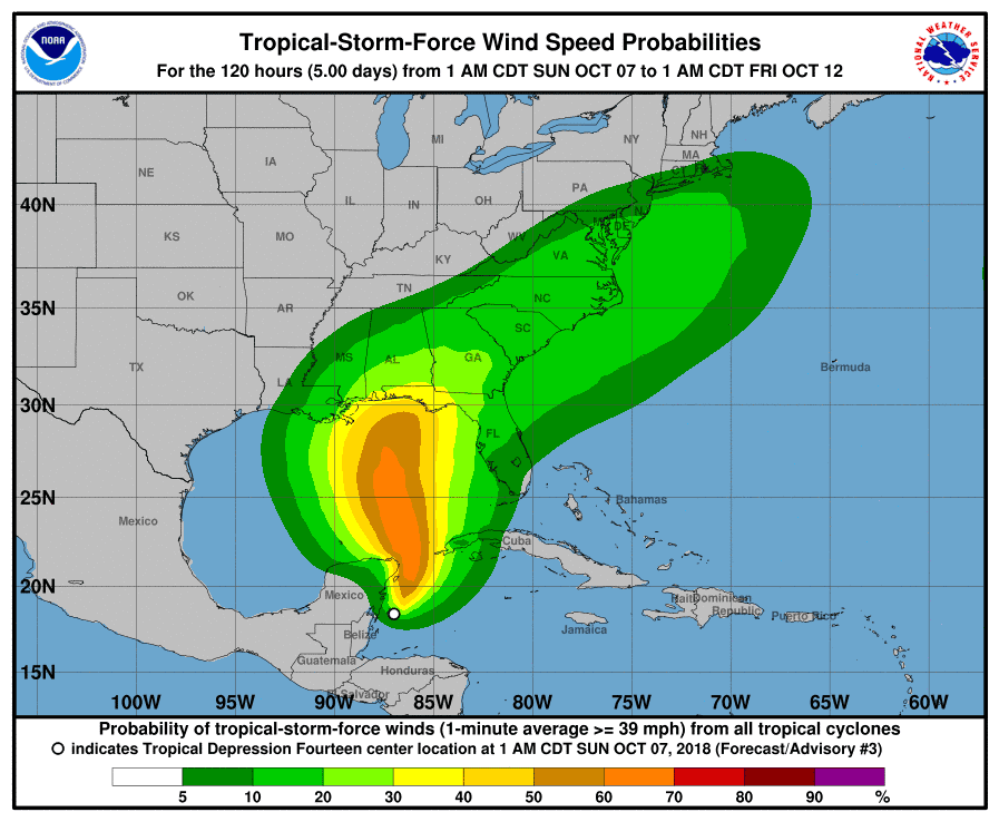

Achilleaze
(15,543 posts)Big old Central America storm is fixing to spit a wicked Boofer Lougee at Yanqui Imperialist Climate Change Denier Liars. In a metaphorical manner of speaking.
Gothmog
(145,243 posts)
csziggy
(34,136 posts)And it works out for my husband and me - Wednesday we leave Tallahassee to drive down to Tampa. Thursday morning we get on a ship and sail to Cozumel for a day on Saturday. The weather in Cozumel should be lovely!
We'll get back to Tallahassee after all the rain and winds are over. Yeah!
I hope this does not pull much moisture up from the Gulf to dump on the Carolinas. They've had enough up there.
DrDan
(20,411 posts)csziggy
(34,136 posts)Maybe soon to be Michael is now stationary - the timing may be slower than originally thought.
The map you linked is the earliest possible arrival - if it speeds up we may leave a day early to drive down to Tampa. While my husband has driven through the middle of a tropical storm, that was ten years ago. We're older now and hopefully wiser!
The most likely arrival of tropical storm winds is Wed. morning: https://www.nhc.noaa.gov/refresh/graphics_at4+shtml/174338.shtml?mltoa34#contents
malaise
(269,004 posts)Last edited Sun Oct 7, 2018, 08:18 PM - Edit history (1)
strengthening will improve
DrDan
(20,411 posts)Last edited Sun Oct 7, 2018, 07:08 PM - Edit history (2)
Been in Fl 35 years and Mike provides best hurricane coverage.
He discusses ALL the models - not tied to one.
He was suggesting this was a serious storm days ago.
malaise
(269,004 posts)I also love Weather Underground


Blue_true
(31,261 posts)Looks like Tallahassee will be right in it's wheelhouse.
csziggy
(34,136 posts)My biggest worry is the food in the refrigerator and freezer - but the last two storms they lent us a generator so I am hoping they can again.
They take care of our horses all the time and our cat when we are gone so we'll just bring in the outdoor furniture and that will be about it.
Blue_true
(31,261 posts)DrDan
(20,411 posts)malaise
(269,004 posts)Get ready folks
roamer65
(36,745 posts)That one looks like it could have a Caribbean track to it.
I have a feeling that one is heading our way.
malaise
(269,004 posts)


underpants
(182,806 posts)Thanks
malaise
(269,004 posts)I check that daily to see what's coming off the African coast.
underpants
(182,806 posts)malaise
(269,004 posts)this time of year.
That said it looks like two more will roll off the African coast this week.