Democratic Underground Latest Greatest Lobby Journals Search Options Help Login
Google

Irene Intensifying Rapidly: on Track for New York & Billion $$ Damages

Printer-friendly format Printer-friendly format
Printer-friendly format Email this thread to a friend
Printer-friendly format Bookmark this thread
This topic is archived.
Home » Discuss » General Discussion Donate to DU
 
FourScore Donating Member (1000+ posts) Send PM | Profile | Ignore Tue Aug-23-11 11:35 PM
Original message
Irene Intensifying Rapidly: on Track for New York & Billion $$ Damages
by FishOutofWater

SNIP

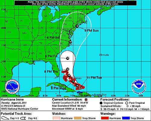
...The eastward shift in Irene's forecast track towards Hatteras Island is great relief for almost everyone in the Carolinas, but it will likely spell a multi-billion dollar disaster for areas further north from the mid-Atlantic to New York to southern New England. The present NHC forecast track takes Irene inland into the Jersey shore south of New York city on a path that will focus a large storm surge and large tides and swells on the Battery of New York City. Damage from surging water in the Battery could be staggering.

11 PM EDT 23August2011 NHC Forecast


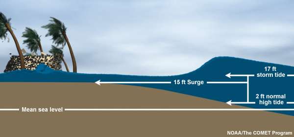
Along the coast, storm surge is often the greatest threat to life and property from a hurricane. In the past, large death tolls have resulted from the rise of the ocean associated with many of the major hurricanes that have made landfall. Hurricane Katrina (2005) is a prime example of the damage and devastation that can be caused by surge. At least 1500 persons lost their lives during Katrina and many of those deaths occurred directly, or indirectly, as a result of storm surge...

SNIP

...Storm Surge vs. Storm Tide

Storm surge is an abnormal rise of water generated by a storm, over and above the predicted astronomical tides. Storm surge should not be confused with storm tide, which is defined as the water level rise due to the combination of storm surge and the astronomical tide. This rise in water level can cause extreme flooding in coastal areas particularly when storm surge coincides with normal high tide, resulting in storm tides reaching up to 20 feet or more in some cases....


SNIP

...The 1921 hurricane struck NYC directly, producing a 4.0 m (13 ft) “wall of water,” which flooded lower Manhattan as far north as Canal Street. The “Long Island Express” of 1938 produced flood heights of 3.0–3.5 m (10–12 ft) in Long Island and up to 5.2 m (17 ft) in southern New England, killing as many as 700 people. Hurricane Donna of 1960 produced the 2.55 m (8.36 ft) highest recorded water level at the Battery and flooded lower Manhattan to West and Cortland Streets. In addition to hurricane storm surge, New York City is also highly vulnerable to extratropical storm surge and sea level rise, especially considering that much of the seawall that protects lower Manhattan is only about 1.5 m above mean sea level ...

http://www.dailykos.com/story/2011/08/23/1009986/-Irene-Intensifying-Rapidly:-on-Track-for-New-York-Billion-$$-Damages?via=siderec
Printer Friendly | Permalink |  | Top
Mz Pip Donating Member (1000+ posts) Send PM | Profile | Ignore Tue Aug-23-11 11:50 PM
Response to Original message
1. Much worse than the earthquake.
Let's hope it peters out before it does too much damage.
Printer Friendly | Permalink |  | Top
 
itsrobert Donating Member (1000+ posts) Send PM | Profile | Ignore Tue Aug-23-11 11:53 PM
Response to Original message
2. You should have put Earthquake in the title
to get more views.
Printer Friendly | Permalink |  | Top
 
nadinbrzezinski Donating Member (1000+ posts) Send PM | Profile | Ignore Tue Aug-23-11 11:56 PM
Response to Original message
3. If this DIRECTLY strikes NYC it will be bad
I wonder if the Mexican Navy is on standby? they were here for Katrina... no, not kidding.

I just hope I don't have to call Boxer again... I mean that.
Printer Friendly | Permalink |  | Top
 
WheelWalker Donating Member (1000+ posts) Send PM | Profile | Ignore Tue Aug-23-11 11:59 PM
Response to Original message
4. It's getting harder and harder to tell reality from reality.
Printer Friendly | Permalink |  | Top
 
Bladian Donating Member (308 posts) Send PM | Profile | Ignore Wed Aug-24-11 12:07 AM
Response to Original message
5. Great. I fly back to Long Island for school Wednesday morning.
As if I wasn't terrified of flying before, now I have to worry about giant waves.
Printer Friendly | Permalink |  | Top
 
The Doctor. Donating Member (1000+ posts) Send PM | Profile | Ignore Wed Aug-24-11 01:17 AM
Response to Original message
6. Why am I getting one of those weird 'abstract modeling' feelings here?

I'm running it over and over, and it just doesn't 'feel' like the epicenter is headed to Manhattan. There's something else. Can't put my finger on it. It would be better if it hits land soon.

I think it will lose much energy before it makes it up to VA. I'm looking at the time stamps, and that just seems about right.

This is one of the few times I hope I'm right.
Printer Friendly | Permalink |  | Top
 
starroute Donating Member (1000+ posts) Send PM | Profile | Ignore Wed Aug-24-11 01:26 AM
Response to Original message
7. If it does flood lower Manhattan, what happens to the 9/11 commemoration?
That's only two weeks later -- not much time to clean up if they do have a serious mess.

But I haven't been keeping track -- is there still a big hole in the ground there, or have they started building something?

If the event does get wiped out, let's put it down to divine vengeance for excluding the first responders. Agreed?

Printer Friendly | Permalink |  | Top
 
Javaman Donating Member (1000+ posts) Send PM | Profile | Ignore Wed Aug-24-11 07:54 AM
Response to Reply #7
15. It becomes a pool party. nt
Printer Friendly | Permalink |  | Top
 
no_hypocrisy Donating Member (1000+ posts) Send PM | Profile | Ignore Wed Aug-24-11 06:38 AM
Response to Original message
8. In 1985 I had to "rescue" my mother from eastern Long Island from Hurricane Gloria.
The traffic between New Jersey and the eastern end (and worse on the way back) was unbelievable. The eye was going to hit where she was. We just missed being hit but had to travel through rain so hard you couldn't see the car ahead of you (bumper-to-bumper).

My point: evacuations will be a nightmare if there's a direct hit of Irene to NYC and/or the Island.
Printer Friendly | Permalink |  | Top
 
malaise Donating Member (1000+ posts) Send PM | Profile | Ignore Wed Aug-24-11 06:39 AM
Response to Original message
9. This is serious
Irene will be a Cat3 before the end of the day
Printer Friendly | Permalink |  | Top
 
NutmegYankee Donating Member (1000+ posts) Send PM | Profile | Ignore Wed Aug-24-11 06:53 AM
Response to Reply #9
10. By the time it hits LI or New England it would be a Cat1.
I am more concerned about the coastal towns on LI and Conn. being smacked by the storm surge. I live about 7 miles inland from the sound, but I'm over several hundred feet above the sound.
Printer Friendly | Permalink |  | Top
 
malaise Donating Member (1000+ posts) Send PM | Profile | Ignore Wed Aug-24-11 07:33 AM
Response to Reply #10
11. and Irene is now a Cat 3 hurricane
...IRENE BECOMES A CATEGORY THREE HURRICANE....EYE HEADED FOR THE CROOKED AND ACKLINS ISLANDS...

http://www.nhc.noaa.gov/index.shtml
Printer Friendly | Permalink |  | Top
 
eShirl Donating Member (1000+ posts) Send PM | Profile | Ignore Wed Aug-24-11 07:39 AM
Response to Original message
12. can't wait for the inevitable hurricane mocking threads
Printer Friendly | Permalink |  | Top
 
NutmegYankee Donating Member (1000+ posts) Send PM | Profile | Ignore Wed Aug-24-11 07:48 AM
Response to Reply #12
13. I'm sure if it hits the Northeast, the laughter will start.
It will be the same story - we are just not prepared for a hurricane.
Printer Friendly | Permalink |  | Top
 
Javaman Donating Member (1000+ posts) Send PM | Profile | Ignore Wed Aug-24-11 07:53 AM
Response to Original message
14. If it clears the cape, then it's on to NY...
Having grown up on LI, we would watch the weather like a hawk anytime there was a Hurricane along the coast.

The rule of thumb is: if a hurricane makes landfall at Cape Hatteras, then NY will usually get only a tropical storm. If the hurricane clears Cape Hatteras, then watch out.

My sister still lives in Queens. I'm keeping an eye on this one.
Printer Friendly | Permalink |  | Top
 
ThomWV Donating Member (1000+ posts) Send PM | Profile | Ignore Wed Aug-24-11 08:12 AM
Response to Original message
16. What absurd fear mongering.
Be afraid, be very afraid.
Printer Friendly | Permalink |  | Top
 
Shagbark Hickory Donating Member (1000+ posts) Send PM | Profile | Ignore Wed Aug-24-11 08:15 AM
Response to Original message
17. What a load of rubbish. These reports sent out by the MSM are to get people to buy batteries.
and keep people glued to their advert filled broadcasts.

Printer Friendly | Permalink |  | Top
 
DU AdBot (1000+ posts) Click to send private message to this author Click to view 
this author's profile Click to add 
this author to your buddy list Click to add 
this author to your Ignore list Fri May 03rd 2024, 08:19 AM
Response to Original message
Advertisements [?]
 Top

Home » Discuss » General Discussion Donate to DU

Powered by DCForum+ Version 1.1 Copyright 1997-2002 DCScripts.com
Software has been extensively modified by the DU administrators


Important Notices: By participating on this discussion board, visitors agree to abide by the rules outlined on our Rules page. Messages posted on the Democratic Underground Discussion Forums are the opinions of the individuals who post them, and do not necessarily represent the opinions of Democratic Underground, LLC.

Home  |  Discussion Forums  |  Journals |  Store  |  Donate

About DU  |  Contact Us  |  Privacy Policy

Got a message for Democratic Underground? Click here to send us a message.

© 2001 - 2011 Democratic Underground, LLC