Democratic Underground Latest Greatest Lobby Journals Search Options Help Login
Google

Holy Shit... Entire Pacific Rim On Alert For Tsunami

Printer-friendly format Printer-friendly format
Printer-friendly format Email this thread to a friend
Printer-friendly format Bookmark this thread
This topic is archived.
Home » Discuss » Archives » General Discussion (1/22-2007 thru 12/14/2010) Donate to DU
 
WillyT Donating Member (1000+ posts) Send PM | Profile | Ignore Sat Feb-27-10 11:09 AM
Original message
Holy Shit... Entire Pacific Rim On Alert For Tsunami
Edited on Sat Feb-27-10 11:12 AM by WillyT


Link: http://www.prh.noaa.gov/ptwc/

Evacuations on Easter Island, and Tsunami Warning Sirens going off in Hawaii according to MSNBC!!!

*******************************************************************************

EVALUATION

A TSUNAMI HAS BEEN GENERATED THAT COULD CAUSE DAMAGE ALONG
COASTLINES OF ALL ISLANDS IN THE STATE OF HAWAII. URGENT ACTION
SHOULD BE TAKEN TO PROTECT LIVES AND PROPERTY.

A TSUNAMI IS A SERIES OF LONG OCEAN WAVES. EACH INDIVIDUAL WAVE
CREST CAN LAST 5 TO 15 MINUTES OR MORE AND EXTENSIVELY FLOOD
COASTAL AREAS. THE DANGER CAN CONTINUE FOR MANY HOURS AFTER THE
INITIAL WAVE AS SUBSEQUENT WAVES ARRIVE. TSUNAMI WAVE HEIGHTS
CANNOT BE PREDICTED AND THE FIRST WAVE MAY NOT BE THE LARGEST.
TSUNAMI WAVES EFFICIENTLY WRAP AROUND ISLANDS. ALL SHORES ARE AT
RISK NO MATTER WHICH DIRECTION THEY FACE. THE TROUGH OF A TSUNAMI
WAVE MAY TEMPORARILY EXPOSE THE SEAFLOOR BUT THE AREA WILL
QUICKLY FLOOD AGAIN. EXTREMELY STRONG AND UNUSUAL NEARSHORE
CURRENTS CAN ACCOMPANY A TSUNAMI. DEBRIS PICKED UP AND CARRIED
BY A TSUNAMI AMPLIFIES ITS DESTRUCTIVE POWER. SIMULTANEOUS HIGH
TIDES OR HIGH SURF CAN SIGNIFICANTLY INCREASE THE TSUNAMI HAZARD.

THE ESTIMATED ARRIVAL TIME IN HAWAII OF THE FIRST TSUNAMI WAVE IS

1119 AM HST SAT 27 FEB 2010

MESSAGES WILL BE ISSUED HOURLY OR SOONER AS CONDITIONS WARRANT.

*************************************************************************************

Link: http://www.prh.noaa.gov/ptwc/messages/hawaii/2010/hawaii.2010.02.27.144739.txt

:wow:
Printer Friendly | Permalink |  | Top
WillyT Donating Member (1000+ posts) Send PM | Profile | Ignore Sat Feb-27-10 11:13 AM
Response to Original message
1. Fixed Link To NOAA Tsunami Center Above...
:kick:
Printer Friendly | Permalink |  | Top
 
wtmusic Donating Member (1000+ posts) Send PM | Profile | Ignore Sat Feb-27-10 11:16 AM
Response to Reply #1
4. I thought they traveled at ±500mph
Wouldn't they have already hit? :shrug:
Printer Friendly | Permalink |  | Top
 
gristy Donating Member (1000+ posts) Send PM | Profile | Ignore Sat Feb-27-10 11:21 AM
Response to Reply #4
8. Yeah, 500mph is about right. -500mph, I don't think so.
:)
Printer Friendly | Permalink |  | Top
 
wtmusic Donating Member (1000+ posts) Send PM | Profile | Ignore Sat Feb-27-10 11:30 AM
Response to Reply #8
13. *smack*
Thanks, I...needed that

:banghead:
Printer Friendly | Permalink |  | Top
 
malaise Donating Member (1000+ posts) Send PM | Profile | Ignore Sat Feb-27-10 11:14 AM
Response to Original message
2. The good news is that Robinson Crusoe island was
not devastated although that island was hit with 3 meter waves. Easter island is next.
Stay alert peeps
Printer Friendly | Permalink |  | Top
 
mix Donating Member (1000+ posts) Send PM | Profile | Ignore Sat Feb-27-10 11:15 AM
Response to Original message
3. I wonder how it will affect people at sea. nt
Printer Friendly | Permalink |  | Top
 
nadinbrzezinski Donating Member (1000+ posts) Send PM | Profile | Ignore Sat Feb-27-10 11:25 AM
Response to Reply #3
10. My hubby told me that at sea
you might feel a little more... if submerged (US Navy), otherwise in the middle of the ocean it is barely noticeable.
Printer Friendly | Permalink |  | Top
 
malaise Donating Member (1000+ posts) Send PM | Profile | Ignore Sat Feb-27-10 11:26 AM
Original message
As long as they are away from the coast they'll be fine
Remember the documentary about the great 1883 eruption of Kracatoa and the captain who took his ship further out to sea.

http://www.dailymail.co.uk/news/worldnews/article-1203028/Will-Krakatoa-rock-world-Last-time-killed-thousands-changed-weather-years-deadlier.html

--
There was a 7.7ft tsunami on a section of the Chilean coast - that's relatively small but the tsunami's impact should be felt more in the West
Printer Friendly | Permalink |  | Top
 
Dappleganger Donating Member (1000+ posts) Send PM | Profile | Ignore Sat Feb-27-10 11:30 AM
Response to Original message
14. Fascinating link, thanks! nt
Printer Friendly | Permalink |  | Top
 
malaise Donating Member (1000+ posts) Send PM | Profile | Ignore Sat Feb-27-10 11:35 AM
Response to Original message
17. I love the pics at the link
Kracatoa always fascinated me and baby Kracatoa is just as fascinating.
I bookmarked this last year. :hi:
Printer Friendly | Permalink |  | Top
 
Dappleganger Donating Member (1000+ posts) Send PM | Profile | Ignore Sat Feb-27-10 11:41 AM
Response to Reply #17
18. Same here, but haven't kept up with baby Kracatoa as much.
As a huge history buff I enjoyed reading different people's accounts of what happened and in particular the world-wide weather changes it caused.
Printer Friendly | Permalink |  | Top
 
pipi_k Donating Member (1000+ posts) Send PM | Profile | Ignore Sat Feb-27-10 11:26 AM
Response to Reply #3
11. A curious thing about tsunami...
is that, out at sea, they're hardly noticeable. They can look like a tiny ripple on the surface of the ocean. A boat floating on the ocean would probably not even notice. It's when they hit the shallower waters that all hell breaks loose.

Printer Friendly | Permalink |  | Top
 
tinrobot Donating Member (1000+ posts) Send PM | Profile | Ignore Sat Feb-27-10 11:26 AM
Response to Reply #3
12. They would hardly even notice it.
If normal waves are like bumps in the road, a tsunami is like the bumpy road going over a hill. You notice yourself rising, then falling, but you'd still mostly feel the smaller bumps.

Tsunamis really only express themselves when they hit land. So, instead of the small bumps hitting the shore, the hill hits the shore.

Printer Friendly | Permalink |  | Top
 
slackmaster Donating Member (1000+ posts) Send PM | Profile | Ignore Sat Feb-27-10 12:11 PM
Response to Reply #3
23. Not much
Just a little bump if you are in deep water.
Printer Friendly | Permalink |  | Top
 
tinrobot Donating Member (1000+ posts) Send PM | Profile | Ignore Sat Feb-27-10 11:19 AM
Response to Original message
5. Time to go surfing.
Seriously, I hope everyone gets to high ground in time.
Printer Friendly | Permalink |  | Top
 
Dappleganger Donating Member (1000+ posts) Send PM | Profile | Ignore Sat Feb-27-10 11:34 AM
Response to Reply #5
15. Surfers and wave-gawkers can be a huge problem...
here in FL they scramble to the beaches as soon as the winds pick up so they can ride dangerously. Wouldn't surprise me if the Pacific loses some people to tsunamis like that as well.
Printer Friendly | Permalink |  | Top
 
gristy Donating Member (1000+ posts) Send PM | Profile | Ignore Sat Feb-27-10 11:20 AM
Response to Original message
6. Entire west coast of N America too. All the way up to Alaska.
Printer Friendly | Permalink |  | Top
 
Odin2005 Donating Member (1000+ posts) Send PM | Profile | Ignore Sat Feb-27-10 11:20 AM
Response to Original message
7. YIKES!
:scared:
Printer Friendly | Permalink |  | Top
 
Name removed Donating Member (0 posts) Send PM | Profile | Ignore Sat Feb-27-10 11:22 AM
Response to Original message
9. Deleted message
Sub-thread removed by moderator. Click here to review the message board rules.
 
WillyT Donating Member (1000+ posts) Send PM | Profile | Ignore Sat Feb-27-10 11:34 AM
Response to Original message
16. Wow... They Just Closed The Airport In Hilo...
Airport in Honolulu is staying open for now...

:wow:
Printer Friendly | Permalink |  | Top
 
nadinbrzezinski Donating Member (1000+ posts) Send PM | Profile | Ignore Sat Feb-27-10 12:10 PM
Response to Reply #16
20. Honolulu Int WILL stay open as long as possilbe
it is also Hickam AF Base... so they will keep that open as long as they can to bring emergency gear in as long as they can.

The fleet most be leaving though.
Printer Friendly | Permalink |  | Top
 
Selatius Donating Member (1000+ posts) Send PM | Profile | Ignore Sat Feb-27-10 12:29 PM
Response to Reply #20
29. As long as the fleet is in open waters, the tsunami will simply pass underneath the ships.
If you're out in the open ocean, the only clue you might get that a tsunami is passing by is that you will see a swell move toward you and pass underneath, lifting up your ship temporarily.
Printer Friendly | Permalink |  | Top
 
nadinbrzezinski Donating Member (1000+ posts) Send PM | Profile | Ignore Sat Feb-27-10 03:25 PM
Response to Reply #29
36. Why they are scrambling
exactomundo
Printer Friendly | Permalink |  | Top
 
WillyT Donating Member (1000+ posts) Send PM | Profile | Ignore Sat Feb-27-10 12:09 PM
Response to Original message
19. Latest: In Wakiki, There Telling People To Stay In Hotels But Go The The 3rd Floor...
Edited on Sat Feb-27-10 12:15 PM by WillyT
http://www.prh.noaa.gov/ptwc/messages/hawaii/2010/hawaii.2010.02.27.165059.txt


***************************************************************************

BULLETIN
TSUNAMI MESSAGE NUMBER 13
NWS PACIFIC TSUNAMI WARNING CENTER EWA BEACH HI
650 AM HST SAT FEB 27 2010

TO - CIVIL DEFENSE IN THE STATE OF HAWAII

SUBJECT - TSUNAMI WARNING SUPPLEMENT

A TSUNAMI WARNING CONTINUES IN EFFECT FOR THE STATE OF HAWAII.

AN EARTHQUAKE HAS OCCURRED WITH THESE PRELIMINARY PARAMETERS

ORIGIN TIME - 0834 PM HST 26 FEB 2010
COORDINATES - 36.1 SOUTH 72.6 WEST
LOCATION - NEAR COAST OF CENTRAL CHILE
MAGNITUDE - 8.8 MOMENT

MEASUREMENTS OR REPORTS OF TSUNAMI WAVE ACTIVITY

GAUGE LOCATION LAT LON TIME AMPL PER
------------------- ----- ------ ----- --------------- -----
DART MANZANILLO 434 16.0N 107.0W 1611Z 0.07M / 0.2FT 24MIN
ACAPULCO MX 16.8N 99.9W 1549Z 0.16M / 0.5FT 24MIN
RIKITEA PF 23.1S 134.9W 1559Z 0.15M / 0.5FT 22MIN
DART MARQUESAS 5140 8.5S 125.0W 1531Z 0.18M / 0.6FT 18MIN
BALTRA GALAPAGS EC 0.4S 90.3W 1452Z 0.35M / 1.2FT 14MIN
EASTER CL 27.2S 109.5W 1205Z 0.35M / 1.1FT 52MIN
ANCUD CL 41.9S 73.8W 0838Z 0.62M / 2.0FT 84MIN
CALLAO LA-PUNTA PE 12.1S 77.2W 1029Z 0.36M / 1.2FT 30MIN
ARICA CL 18.5S 70.3W 1008Z 0.94M / 3.1FT 42MIN
IQUIQUE CL 20.2S 70.1W 0907Z 0.28M / 0.9FT 68MIN
ANTOFAGASTA CL 23.2S 70.4W 0941Z 0.49M / 1.6FT 52MIN
DART LIMA 32412 18.0S 86.4W 0941Z 0.24M / 0.8FT 36MIN
CALDERA CL 27.1S 70.8W 0843Z 0.45M / 1.5FT 20MIN
TALCAHUANO CL 36.7S 73.4W 0653Z 2.34M / 7.7FT 88MIN
COQUIMBO CL 30.0S 71.3W 0852Z 1.32M / 4.3FT 30MIN
CORRAL CL 39.9S 73.4W 0739Z 0.90M / 2.9FT 16MIN
SAN FELIX CL 26.3S 80.1W 0815Z 0.53M / 1.7FT 08MIN
VALPARAISO CL 33.0S 71.6W 0708Z 1.29M / 4.2FT 20MIN

LAT - LATITUDE (N-NORTH, S-SOUTH)
LON - LONGITUDE (E-EAST, W-WEST)
TIME - TIME OF THE MEASUREMENT (Z IS UTC IS GREENWICH TIME)
AMPL - TSUNAMI AMPLITUDE MEASURED RELATIVE TO NORMAL SEA LEVEL.
IT IS ...NOT... CREST-TO-TROUGH WAVE HEIGHT.
VALUES ARE GIVEN IN BOTH METERS(M) AND FEET(FT).
PER - PERIOD OF TIME IN MINUTES(MIN) FROM ONE WAVE TO THE NEXT.

EVALUATION

A TSUNAMI HAS BEEN GENERATED THAT COULD CAUSE DAMAGE ALONG
COASTLINES OF ALL ISLANDS IN THE STATE OF HAWAII. URGENT ACTION
SHOULD BE TAKEN TO PROTECT LIVES AND PROPERTY.

A TSUNAMI IS A SERIES OF LONG OCEAN WAVES. EACH INDIVIDUAL WAVE
CREST CAN LAST 5 TO 15 MINUTES OR MORE AND EXTENSIVELY FLOOD
COASTAL AREAS. THE DANGER CAN CONTINUE FOR MANY HOURS AFTER THE
INITIAL WAVE AS SUBSEQUENT WAVES ARRIVE. TSUNAMI WAVE HEIGHTS
CANNOT BE PREDICTED AND THE FIRST WAVE MAY NOT BE THE LARGEST.
TSUNAMI WAVES EFFICIENTLY WRAP AROUND ISLANDS. ALL SHORES ARE AT
RISK NO MATTER WHICH DIRECTION THEY FACE. THE TROUGH OF A TSUNAMI
WAVE MAY TEMPORARILY EXPOSE THE SEAFLOOR BUT THE AREA WILL
QUICKLY FLOOD AGAIN. EXTREMELY STRONG AND UNUSUAL NEARSHORE
CURRENTS CAN ACCOMPANY A TSUNAMI. DEBRIS PICKED UP AND CARRIED
BY A TSUNAMI AMPLIFIES ITS DESTRUCTIVE POWER. SIMULTANEOUS HIGH
TIDES OR HIGH SURF CAN SIGNIFICANTLY INCREASE THE TSUNAMI HAZARD.

THE ESTIMATED ARRIVAL TIME IN HAWAII OF THE FIRST TSUNAMI WAVE IS

1105 AM HST SAT 27 FEB 2010

MESSAGES WILL BE ISSUED HOURLY OR SOONER AS CONDITIONS WARRANT.

******************************************************************************

Link: http://www.prh.noaa.gov/ptwc/?region=2

:grouphug:
Printer Friendly | Permalink |  | Top
 
nadinbrzezinski Donating Member (1000+ posts) Send PM | Profile | Ignore Sat Feb-27-10 12:12 PM
Response to Reply #19
24. It is less than a foot in Mexico
readying the Acapulco, Marquesas and other reports.

So hopefully it will have dissipated and will be minor.

Now OB in San Diego will get flooded... between this and the storm surge... it ALWAYS gets flooded.
Printer Friendly | Permalink |  | Top
 
slackmaster Donating Member (1000+ posts) Send PM | Profile | Ignore Sat Feb-27-10 12:15 PM
Response to Reply #24
26. My ex lives in IB. I just left her a voice mail in case she's not paying attention
Printer Friendly | Permalink |  | Top
 
nadinbrzezinski Donating Member (1000+ posts) Send PM | Profile | Ignore Sat Feb-27-10 12:15 PM
Response to Reply #26
27. Without smorm surge
that be nothing
Printer Friendly | Permalink |  | Top
 
WillyT Donating Member (1000+ posts) Send PM | Profile | Ignore Sat Feb-27-10 12:38 PM
Response to Reply #27
30. Um...
I certainly hope you are correct, but this concerns me...

<snip>

While everyday wind waves have a wavelength (from crest to crest) of about 100 metres (330 ft) and a height of roughly 2 metres (6.6 ft), a tsunami in the deep ocean has a wavelength of about 200 kilometres (120 mi). Such a wave travels at well over 800 kilometres per hour (500 mph), but due to the enormous wavelength the wave oscillation at any given point takes 20 or 30 minutes to complete a cycle and has an amplitude of only about 1 metre (3.3 ft).<10> This makes tsunamis difficult to detect over deep water. Ships rarely notice their passage.

As the tsunami approaches the coast and the waters become shallow, wave shoaling compresses the wave and its velocity slows below 80 kilometres per hour (50 mph). Its wavelength diminishes to less than 20 kilometres (12 mi) and its amplitude grows enormously, producing a distinctly visible wave. Since the wave still has such a long wavelength, the tsunami may take minutes to reach full height. Except for the very largest tsunamis, the approaching wave does not break (like a surf break), but rather appears like a fast moving tidal bore.<11> Open bays and coastlines adjacent to very deep water may shape the tsunami further into a step-like wave with a steep-breaking front.


When the tsunami's wave peak reaches the shore, the resulting temporary rise in sea level is termed run up. Run up is measured in metres above a reference sea level.<11> A large tsunami may feature multiple waves arriving over a period of hours, with significant time between the wave crests. The first wave to reach the shore may not have the highest run up.<12>


<snip>

Link: http://en.wikipedia.org/wiki/Tsunami

IOW - A one foot, or a one meter wave, is not necessarily still one foot, or one meter when it comes on shore. Am I getting this right???

:shrug:
Printer Friendly | Permalink |  | Top
 
nadinbrzezinski Donating Member (1000+ posts) Send PM | Profile | Ignore Sat Feb-27-10 03:29 PM
Response to Reply #30
37. They detected 0.98 meters in Acapulco Mexico
that is inside the Bay... so that might make a difference.

Granted, that is a high wave for the inside the bay.

The US Navy is scrambling in both Hawaii and SD... (and if they are also scrambling Wibley Island they won't tell, SSNs there)

There has to be a reason for that.

Funny, they have sirens installed all along the coast in from LA to SD now, not that most Californians would know what that means.
Printer Friendly | Permalink |  | Top
 
4lbs Donating Member (1000+ posts) Send PM | Profile | Ignore Sat Feb-27-10 12:11 PM
Response to Original message
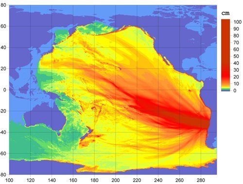
21. As far as I see, only the coast of Chile has the RED, or HIGH Severity warning. Every other place,
including Hawaii, has a GREEN, or LOW Severity warning.

That means that the 'damage' to Hawaii's coastline would be no worse than the 15-foot waves that crash on Hawaii's beaches during a normal rainstorm.

Besides, Hawaii is 3000+ miles away from the epicenter of that Chile quake.

By comparison, remember the 2004 Indian Ocean Earthquake and Tsunami? That quake was about a 9.1, and the coast of India that was within 500 miles of the epicenter, was hit with 40-foot waves that caused flooding several miles inland. However, the coast of Africa was 3000 miles away, and only got 15-foot waves, and no flooding past the immediate beach area.

Printer Friendly | Permalink |  | Top
 
fascisthunter Donating Member (1000+ posts) Send PM | Profile | Ignore Sat Feb-27-10 12:11 PM
Response to Original message
22. oh no
Printer Friendly | Permalink |  | Top
 
slackmaster Donating Member (1000+ posts) Send PM | Profile | Ignore Sat Feb-27-10 12:13 PM
Response to Original message
25. Life Jackets Issued To All Americans For Some Reason
Printer Friendly | Permalink |  | Top
 
Subdivisions Donating Member (1000+ posts) Send PM | Profile | Ignore Sat Feb-27-10 12:19 PM
Response to Original message
28. Thanks mods. That'll teach me not to skip to the meaty bits without
Edited on Sat Feb-27-10 12:20 PM by Subdivisions
first checking the date.
Printer Friendly | Permalink |  | Top
 
WillyT Donating Member (1000+ posts) Send PM | Profile | Ignore Sat Feb-27-10 01:36 PM
Response to Original message
31. Latest Advisories And Warnings:
<snip>

HAWAII under TSUNAMI WARNING with EVACUACTIONS in effect

A Tsunami Advisory is in effect which includes the coastal areas of California from the California-Mexico border to the Oregon-California border.

A Tsunami Advisory is in effect which includes the coastal areas of Oregon, Washington, British Columbia and Alaska from the Oregon-California border to Kodiak, Alaska.

<snip>

Plus...

<snip>

A TSUNAMI WARNING IS IN EFFECT FOR

CHILE / PERU / ECUADOR / COLOMBIA / ANTARCTICA / PANAMA /
COSTA RICA / NICARAGUA / PITCAIRN / HONDURAS / EL SALVADOR /
GUATEMALA / FR. POLYNESIA / MEXICO / COOK ISLANDS / KIRIBATI /
KERMADEC IS / NIUE / NEW ZEALAND / TONGA / AMERICAN SAMOA /
SAMOA / JARVIS IS. / WALLIS-FUTUNA / TOKELAU / FIJI /
AUSTRALIA / HAWAII / PALMYRA IS. / TUVALU / VANUATU /
HOWLAND-BAKER / NEW CALEDONIA / JOHNSTON IS. / SOLOMON IS. /
NAURU / MARSHALL IS. / MIDWAY IS. / KOSRAE / PAPUA NEW GUINEA /
POHNPEI / WAKE IS. / CHUUK / RUSSIA / MARCUS IS. / INDONESIA /
N. MARIANAS / GUAM / YAP / BELAU / JAPAN / PHILIPPINES /
CHINESE TAIPEI

<snip>

Link: http://www.examiner.com/x-6116-Portland-Active-Seniors-Travel-Examiner~y2010m2d27-Major-Chili-Earthquakes--Tsunami-Advisory

:scared::wow::scared:
Printer Friendly | Permalink |  | Top
 
ellie Donating Member (1000+ posts) Send PM | Profile | Ignore Sat Feb-27-10 02:05 PM
Response to Original message
32. I am friends with
the T-Shirt Hell guy on Facebook and he just posted that he is in Kauai in a beach front hotel room and was told to evacuate.
Printer Friendly | Permalink |  | Top
 
WillyT Donating Member (1000+ posts) Send PM | Profile | Ignore Sat Feb-27-10 02:19 PM
Response to Reply #32
33. If He Keeps Posting, Let Us Know Please !!!
MSNBC said earlier that in Oahu, they are telling people to go to the 3rd floor or higher in the high-rise hotels there.

:shrug:

:hi:
Printer Friendly | Permalink |  | Top
 
ellie Donating Member (1000+ posts) Send PM | Profile | Ignore Sat Feb-27-10 08:28 PM
Response to Reply #33
40. His last post said
that Civil Defense made him evacuate but that was six hours ago.
Printer Friendly | Permalink |  | Top
 
brettdale Donating Member (1000+ posts) Send PM | Profile | Ignore Sat Feb-27-10 02:24 PM
Response to Original message
34. The whole east coast of NewZealand
Edited on Sat Feb-27-10 02:24 PM by brettdale
Is on Tsunami watch.
Printer Friendly | Permalink |  | Top
 
WillyT Donating Member (1000+ posts) Send PM | Profile | Ignore Sat Feb-27-10 02:30 PM
Response to Original message
35. WOW !!! - From NOAA Through HuffPo
<snip>

1:55 PM ET -- Info charts from the West Coast and Alaska Tsunami Warning Center.

This first one shows what the NOAA web site refers to as a "preliminary forecast model energy map."


This second one shows the projected tsunami travel times following this morning's earthquake in Chile.


<snip>

Link: http://www.huffingtonpost.com/2010/02/27/chile-earthquake-tsunami_n_479393.html

:wow:


Printer Friendly | Permalink |  | Top
 
tekisui Donating Member (1000+ posts) Send PM | Profile | Ignore Sat Feb-27-10 03:49 PM
Response to Original message
38. Live stream from Hawaii.
Printer Friendly | Permalink |  | Top
 
muriel_volestrangler Donating Member (1000+ posts) Send PM | Profile | Ignore Sat Feb-27-10 04:05 PM
Response to Original message
39. Wave up to 13 ft in the Marquesas
Large waves are reported to have struck Chile's Juan Fernandez island group, reaching halfway into one inhabited area. Three people there are missing, local media say. Two aid ships are reported to be on their way.

Part of the Marquesas Islands in French Polynesia were hit by a 4m (13ft) wave, but no casualties were reported, AFP news agency said.

http://news.bbc.co.uk/1/hi/world/americas/8540742.stm
Printer Friendly | Permalink |  | Top
 
DU AdBot (1000+ posts) Click to send private message to this author Click to view 
this author's profile Click to add 
this author to your buddy list Click to add 
this author to your Ignore list Wed May 01st 2024, 08:05 PM
Response to Original message
Advertisements [?]
 Top

Home » Discuss » Archives » General Discussion (1/22-2007 thru 12/14/2010) Donate to DU

Powered by DCForum+ Version 1.1 Copyright 1997-2002 DCScripts.com
Software has been extensively modified by the DU administrators


Important Notices: By participating on this discussion board, visitors agree to abide by the rules outlined on our Rules page. Messages posted on the Democratic Underground Discussion Forums are the opinions of the individuals who post them, and do not necessarily represent the opinions of Democratic Underground, LLC.

Home  |  Discussion Forums  |  Journals |  Store  |  Donate

About DU  |  Contact Us  |  Privacy Policy

Got a message for Democratic Underground? Click here to send us a message.

© 2001 - 2011 Democratic Underground, LLC