I know that the Ohio is used extensively as a state border (Navigable rivers are under Federal Control so different shores belonging to different states are NOT a problem is most of the US) but please remember Rivers UNITE people they do NOT divide people (Just look at the Egypt and the Nile, the Yellow and Yangtze Rivers and China, Ganges of Northern India (And the Indus River of Pakistan), Argentina and the Paraná River. Brazil and the Amazon, The Ukraine and the Dneiper River, Poland and the Vistula, Germany, Switzerland, Netherlands and Belgium and the Rhine River, France the the Seine, Meuse, Loire, and the Rhone Rivers, The Republic of the Congo and the Congo, Nigeria and Niger and the Niger River, Venezuela and the Orinoco River, The Zimbabwe and Mozambique and the Zambezi River, as while as Russia and the Volga, Don, Dvina (Often called the Northern Dvina), the Daugava River (Often called the Western Dvina) and the Ural Rivers.
The above River unite the above Countries (In the case of France and the Rhine, the Rhine has NEVER been the natural Eastern Border of France, for the area to this day speaks German, for the draw of the Rhine is to Germany, and the Low Countries NOT Paris and the rest of France (LOuis XIV wanted the Rhine as France's Eastern Border and he achieved it, sent France on the long road to Bankruptcy and Revolution just less then 100 years later but he achieved it, at huge cost to France, even when Rome Ruled what is now France, the Rhine Valley was called "Germany" by the Romans NOT Gaul, as the rest of Modern France was called by the Ancient Romans).
My point is River Unite and thus make poor Borders (Bismark knew this and when he convened the meeting that produced the Treaty of Berlin, that divided up Africa, he deliberately drew borders along rivers so that the rest of Europe would come into conflict on these Water ways, Conflicts Bismark hoped to keep the rest of Europe divided so they could NOT all attack Germany at once, i.e. avoid the Alliances that came to be just before WWI and lead to WWI).
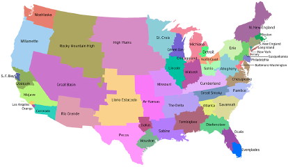
The Biggest problem is the cities of St Louis and Cairo. St Louis sits where the Missouri joins the Mississippi, Cairo sits where the Ohio joins the Mississippi. If anything these two points should be in one jurisdiction. I know just a merger would destroy preserving the borders of Missouri, AND the present Southern Borders of Illinois, Indiana and Ohio, but in any ration plan for states the Ohio River should NOT be used as a State Border. Once you eliminate the Ohio River as a Border, so goes the remaining existing borders in that area. Just pointing out the chief weakness of this approach to State Borders. State Borders should reflect regional needs. Most state Borders have NEVER done that, given most state borders were drawn by Washington Bureaucrats for administrative purposes during the times such states were Territories of the US (This excludes the 13 Colonies, Vermont and Texas). These were never intended to be permanent, but over time became permanent and later State Borders once the Territory had more then 50,000 people in the Territory. For this reason we do need to re-draw the borders of the states, but NOT to keep each state the same in population, but to reflect what is needed on a local basis (I.e. Roads, Schools and other GOvernment Services). The above borders do reflect some of these needs but in the low population areas of the American West ignores the need for local control of who gets what water. This is a good reference point, but a better way to look at State Borders would be to view a State needing to be on both sides of a River and its Drainage Area. Some Drainage areas are to large for one state (The Mississippi Drainage area for one) but it is a better start then keeping existing borders AND equal population.
New State Borders have been discussed before on DU:
http://www.democraticunderground.com/discuss/duboard.php?az=view_all&address=102x4222933#4226109http://www.democraticunderground.com/discuss/duboard.php?az=view_all&address=103x411848#411976http://www.democraticunderground.com/discuss/duboard.php?az=view_all&address=102x1255331#1258005http://www.democraticunderground.com/discuss/duboard.php?az=view_all&address=102x3631354#3633200http://www.democraticunderground.com/discuss/duboard.php?az=view_all&address=115x191680#191877http://www.democraticunderground.com/discuss/duboard.php?az=view_all&address=102x1860037#1864850http://www.democraticunderground.com/discuss/duboard.php?az=view_all&address=102x2013716#2014053Among Other sites on DU where this and related subjects has been discussed