
The Warsaw Ghetto wall
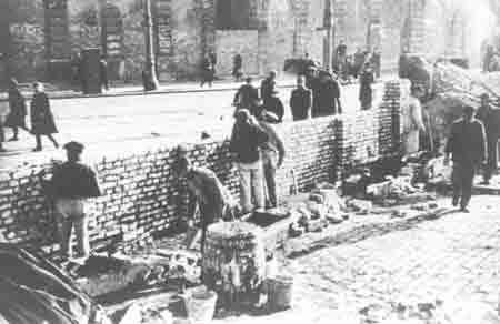
To create the Warsaw Ghetto, the Germans built 11 miles of brick walls around the Jewish quarter; this area was then closed to outsiders on November 15, 1940. The wall was torn down in 1943 when the Ghetto was liquidated. Today there is only one short section of the original wall remaining; this section was outside the Ghetto when the original Ghetto became a smaller area after most of the Jews had been deported.
The photo above shows this remaining section of the wall, which is about 10 feet high. According to my tour guide, parts of the wall which connected two buildings, such as this section, were built higher than the rest of the wall, which was mostly lower than 10 feet. On the wall is a map showing the area of the Ghetto. The courtyard in front of the wall is located at ul. Zlota 62. (Some guidebooks says the address is Number 60 Zlota Street.)

The photo below shows a closeup of the map of the Warsaw Ghetto. The map shows the Ghetto divided into two parts. The top section, on the northern border, is where the Umschlagplatz and Mila 18 were located. The bottom section is where the Nozyk Synagogue, the only one that survived, still stands today.
More:
http://www.scrapbookpages.com/Poland/WarsawGhetto/WarsawGhetto05.htmlSee also:
Warsaw Ghetto
From Wikipedia, the free encyclopedia
The Warsaw Ghetto was the largest of the Jewish ghettos established by Nazi Germany in the General Government during the Holocaust in World War II. In the three years of its existence, starvation, disease and deportations to concentration camps and extermination camps dropped the population of the ghetto from an estimated 450,000 to 37,000. The Warsaw Ghetto was the scene of the Warsaw Ghetto Uprising, one of the first mass uprisings against Nazi occupation in Europe.
More:
http://en.wikipedia.org/wiki/Warsaw_Ghetto