Democratic Underground Latest Greatest Lobby Journals Search Options Help Login
Google

Report lists America's 10 most endangered rivers

Printer-friendly format Printer-friendly format
Printer-friendly format Email this thread to a friend
Printer-friendly format Bookmark this thread
This topic is archived.
Home » Discuss » Archives » General Discussion (1/22-2007 thru 12/14/2010) Donate to DU
 
seemslikeadream Donating Member (1000+ posts) Send PM | Profile | Ignore Tue Apr-07-09 10:09 AM
Original message
Report lists America's 10 most endangered rivers
http://www.cnn.com/2009/TECH/science/04/07/rivers.endangered.list/


1) Sacramento-San Joaquin River System

Location: California

Outdated water and flood management puts California's largest watershed at the top of America's most endangered rivers list for 2009. A recent breach in the delta's 1,100-mile levee system could have dire effects on surrounding ecosystems, farming and agriculture, commercial fishing and California's civil infrastructure. State and federal authorities are looking at alternative water-management strategies for the river system, which serves 25 million Californians and more than 5 million acres of farmland.

2) Flint River

Location: Georgia

The Flint is one of 40 rivers nationwide that still flow undammed for more than 200 miles. Conservationists say that dams proposed by Georgia lawmakers would bury more than 50 river miles, destroy fishing and boating opportunities and cost taxpayers millions of dollars. The American Rivers group believes that fixing the state's leaky pipes, using water meters and minimizing water waste would be a cheaper and more cost-effective alternative.

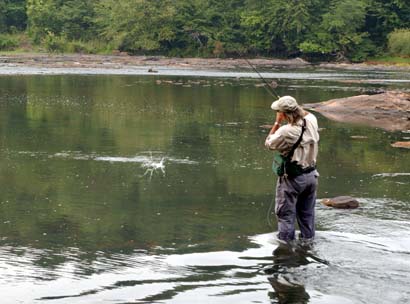
3) Lower Snake River

Location: Idaho, Washington, Oregon

The U.S. Army Corps of Engineers has built four dams to irrigate and generate energy for the Northwest, but these dams also prevent salmon and steelhead trout from reaching their spawning areas. Every year, those dams kill as many as 90 percent of juvenile salmon and steelhead trout that migrate downstream to the ocean. Conservationists say that removing the dams would eliminate a growing flood threat in Lewiston, Idaho, and create an opportunity to modernize the region's transportation and energy systems.

4) Mattawoman Creek

Location: Maryland

A highway development project here jeopardizes one of the Chesapeake Bay's few remaining healthy streams. The project threatens clean water sources, thousands of acres of forests and wetlands, and an internationally-renowned, multimillion-dollar largemouth bass fishery.

5) North Fork of the Flathead River

Location: Montana

A proposed coal-mining project across the Canadian border puts Montana's North Fork of the Flathead River in jeopardy. An estimated 50,000 acres of the Flathead headwaters could be transformed into an industrial gas field. The projects threaten the river's clean water, local agriculture, fish and wildlife and recreational industries such as rafting, camping, fishing and boating. American Rivers and its partners have called on local Canadian governments and the U.S. State Department to work together to halt these projects.

6) Saluda River

Location: South Carolina

Excess levels of sewage waste threaten the drinking water of more than 500,000 South Carolina residents, conservationists say. Sewage in the river increases phosphorous and algae levels, depletes oxygen, and kills fish and other aquatic life. American Rivers is asking the South Carolina Department of Health and Environmental Control to improve sewage-treatment standards and ensure the river reduces its phosphorous levels by 25 to 50 percent.

7) Laurel Hill Creek

Location: Pennsylvania

Known for its fishing, swimming and kayaking, this popular vacation spot faces threats from a bottling plant and tourism-related development. Without adequate planning and safeguards, withdrawals will continue to exceed the creek's reasonable capacity, putting recreation, the local water supply, and fish and wildlife in jeopardy.

8) Beaver Creek

Location: Alaska

One of the nation's last wild rivers faces extinction if an oil- and gas-development project constructs 600 miles of roads and pipelines, airstrips, drilling pads, and gravel mines along the creek. Alaska native communities depend on the area for subsistence hunting and fishing. It's also a popular destination for anglers, boaters, skiers and hunters.

9) Pascagoula River

Location: Mississippi

The U.S. Department of Energy wants to hollow out natural salt domes 30 miles northwest of the Pascagoula to create a storage area for up to 160 million barrels of oil. A pipeline 330 miles in length would be constructed to withdraw water from the Pascagoula to dissolve the salt domes and distribute oil to and from the site. The DOE predicts 18 oil spills and 75 spills of salty, polluted water during the construction and initial fill of the hollowed domes, damaging rivers, streams, and wetlands in the basin, conservationists say.

10) Lower St. Croix National Scenic Riverway

Location: Minnesota, Wisconsin
Printer Friendly | Permalink |  | Top
Squatch Donating Member (1000+ posts) Send PM | Profile | Ignore Tue Apr-07-09 10:21 AM
Response to Original message
1. The Snake R makes the list every year...
I would love nothing more than to see that river (including its tributaries like the Clearwater) free-flowing along it entire length.
Printer Friendly | Permalink |  | Top
 
ensho Donating Member (1000+ posts) Send PM | Profile | Ignore Tue Apr-07-09 10:30 AM
Response to Original message
2. they should add Florida's River of Grass to the list

nt
Printer Friendly | Permalink |  | Top
 
DemoTex Donating Member (1000+ posts) Send PM | Profile | Ignore Tue Apr-07-09 10:41 AM
Response to Original message
3. I grew up camping, fishing, and kayaking the Flint River.
Edited on Tue Apr-07-09 10:41 AM by DemoTex
The Flint River (which begins as a spring under the runways of the Atlanta Hartsfield-Jackson airport), especially the section from GA-18 (just south of Flat Shoals) as it runs through slightly mountainous near-wilderness to GA-36 (at Yellow Jacket Shoals), is indescribably beautiful. The names are are a rich part of my outdoor heritage: Dripping Rock, Thundering Springs, Sprewell Bluff, and Yellow Jacket Shoals.

In that section of the Flint River is a species of red-eyed small-mouth shoal bass that is found nowhere else. My brother and I fly-fish the shoals of the Flint near Dripping Rock with "Wooly-Boogers" and catch the limit of shoal bass.

Jimmy Carter saved the Flint River when he was the governor of Georgia in the early 1970s. The powers-that-be wanted to dam the Flint at Sprewell Bluff. It sounds like we need Jimmy Carter's level-headed influence again.

Printer Friendly | Permalink |  | Top
 
DemoTex Donating Member (1000+ posts) Send PM | Profile | Ignore Tue Apr-07-09 09:30 PM
Response to Reply #3
5. My brother just called .. it is GOP congressmen pushing for a dam at Sprewell Bluff.
The new Sprewell Bluff dam plan is mainly a pet project of an asshole named Lynn Westmoreland (R-GA). They (the GA GOP) are now blaming the Georgia drought problems on Gov. Jimmy Carter for blocking the Sprewell Dam in 1972.

To dam the Flint at Sprewell Bluff will kill 20-30 miles of the best wild river in the nation. I worked at Camp Thunder, a BSA camp on the river, two seasons in the early 1960s. I enjoyed the river and environs for several years before that, as a BSA camper. A dying friend of mine, Gerald Lawhorn, has funded a canoe center at Dripping Rock.

It is important to save these rivers. Our lives depend on them.
Printer Friendly | Permalink |  | Top
 
hunter Donating Member (1000+ posts) Send PM | Profile | Ignore Tue Apr-07-09 11:02 AM
Response to Original message
4. The Sacramento-San Joaquin River System is an ongoing environmental disaster.
It has very great potential to be a television news flooding disaster too. Pile that on top of a big earthquake and it's a national economy buster.
Printer Friendly | Permalink |  | Top
 
DemoTex Donating Member (1000+ posts) Send PM | Profile | Ignore Tue Apr-07-09 10:01 PM
Response to Original message
6. And then there is #6 -- the Saluda River --literally in my back yard.
We have an organization .. the SOS (Save Our Saluda) .. fighting them now. The "thems" we are fighting (thank you Steven Colbert) are the serious "thems," those with "The Cliffs" in their appellation. They are the ones who want to pump the rich mens' shit from their super high-end "Cliff" developments into our Saluda river (two miles from the proposed shit-site the Saluda is an irrigation source for a beautiful low-land of crops .. corn, tomatoes, peppers, etc.).
Printer Friendly | Permalink |  | Top
 
DemoTex Donating Member (1000+ posts) Send PM | Profile | Ignore Wed Apr-08-09 08:20 PM
Response to Original message
7. Kick an important thread ..
:kick:
Printer Friendly | Permalink |  | Top
 
DU AdBot (1000+ posts) Click to send private message to this author Click to view 
this author's profile Click to add 
this author to your buddy list Click to add 
this author to your Ignore list Thu May 02nd 2024, 03:14 AM
Response to Original message
Advertisements [?]
 Top

Home » Discuss » Archives » General Discussion (1/22-2007 thru 12/14/2010) Donate to DU

Powered by DCForum+ Version 1.1 Copyright 1997-2002 DCScripts.com
Software has been extensively modified by the DU administrators


Important Notices: By participating on this discussion board, visitors agree to abide by the rules outlined on our Rules page. Messages posted on the Democratic Underground Discussion Forums are the opinions of the individuals who post them, and do not necessarily represent the opinions of Democratic Underground, LLC.

Home  |  Discussion Forums  |  Journals |  Store  |  Donate

About DU  |  Contact Us  |  Privacy Policy

Got a message for Democratic Underground? Click here to send us a message.

© 2001 - 2011 Democratic Underground, LLC