Democratic Underground Latest Greatest Lobby Journals Search Options Help Login
Google

i`m posting this here because i know this forum will appreciate this

Printer-friendly format Printer-friendly format
Printer-friendly format Email this thread to a friend
Printer-friendly format Bookmark this thread
This topic is archived.
Home » Discuss » DU Groups » Arts & Entertainment » Photography Group Donate to DU
 
madrchsod Donating Member (1000+ posts) Send PM | Profile | Ignore Tue May-12-09 11:25 AM
Original message
i`m posting this here because i know this forum will appreciate this
Printer Friendly | Permalink |  | Top
Mz Pip Donating Member (1000+ posts) Send PM | Profile | Ignore Tue May-12-09 11:56 AM
Response to Original message
1. Amazing pictures
I wonder what the story behind that photograph is. Very compelling.
Printer Friendly | Permalink |  | Top
 
ConsAreLiars Donating Member (1000+ posts) Send PM | Profile | Ignore Wed May-13-09 02:34 AM
Response to Reply #1
3. My understanding of what is being shown --
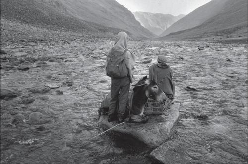
In Afghanistan river bottoms are the best routes for travel most of the year, given the lack of roads. The photo seems to show the photographer, given the clothes and backpack, with his guide and mule, taking a rest break.

Here's a photo by Luke Powell http://www.lukepowell.com/ , with a few of his comments below it:


"In the 1970's, on most maps of Afghanistan showed a road which made a great circle around the country with roads that radiate from this ring to Meshed, Peshawer, Quetta, and points in Soviet Turkestan, Uzbekistan, and the Tadjik S.S.R. Much of this circle of roads was hard surface highway built during the 1960's by the United States and the Soviet Union. The American-built stretches were very much like a minor secondary road in the United States, narrow asphalt that was thin enough to be in need of frequent repair; the Soviet-built parts were concrete, three lanes wide and a meter deep, solid enough for tanks. However, the northern route from Shebergan to just northeast of Herat, while shown on most maps, did not in fact exist. This is what the northern route was like. It was a trail for fourwheel vehicles only, and it was impassable for many weeks of the year. This was still the case when I returned in 2003."

Printer Friendly | Permalink |  | Top
 
ConsAreLiars Donating Member (1000+ posts) Send PM | Profile | Ignore Wed May-13-09 02:17 AM
Response to Original message
2. Looks like a very compelling journey/tale/exhibit.
Edited on Wed May-13-09 02:17 AM by ConsAreLiars
Gone at 50...

For those interested in "seeing" more of Afghanistan, I recommend the link in my sig to http://LukePowell.com for photos from the 70's, during the Taliban period and after the US invasion.


(edit typo)
Printer Friendly | Permalink |  | Top
 
DU AdBot (1000+ posts) Click to send private message to this author Click to view 
this author's profile Click to add 
this author to your buddy list Click to add 
this author to your Ignore list Sat May 04th 2024, 02:14 AM
Response to Original message
Advertisements [?]
 Top

Home » Discuss » DU Groups » Arts & Entertainment » Photography Group Donate to DU

Powered by DCForum+ Version 1.1 Copyright 1997-2002 DCScripts.com
Software has been extensively modified by the DU administrators


Important Notices: By participating on this discussion board, visitors agree to abide by the rules outlined on our Rules page. Messages posted on the Democratic Underground Discussion Forums are the opinions of the individuals who post them, and do not necessarily represent the opinions of Democratic Underground, LLC.

Home  |  Discussion Forums  |  Journals |  Store  |  Donate

About DU  |  Contact Us  |  Privacy Policy

Got a message for Democratic Underground? Click here to send us a message.

© 2001 - 2011 Democratic Underground, LLC