Arctic sea ice extent at end of December 2009 remained below normal, primarily in the Atlantic sector of the Arctic. Average air temperatures over the Arctic Ocean were much higher than normal for the month, reflecting unusual atmospheric conditions. Finally, we provide a review of 2009 Arctic sea ice conditions.
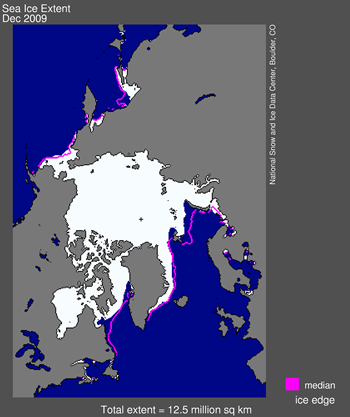
Figure 1. Arctic sea ice extent for December 2009 was 12.48 million square kilometers (4.82 million square miles). The magenta line shows the 1979 to 2000 median extent for that month. The black cross indicates the geographic North Pole.
Overview of conditions
Arctic sea ice extent averaged over December 2009 was 12.48 million square kilometers (4.82 million square miles). This was 920,000 square kilometers (350,000 square miles) below the 1979 to 2000 average for December, but 210,000 square kilometers (81,000 square miles) above the record low for the month, which occurred in December 2006. Ice extent was less than normal over much of the Atlantic sector of the Arctic, including the Barents Sea, part of the East Greenland Sea, and in Davis Strait.
Conditions in context
During December 2009, ice extent grew at an average of 68,000 square kilometers (26,000 square miles) per day. Sea ice extent increased at a fairly steady rate throughout the month, staying slightly above the levels observed in December 2007.
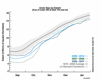
Figure 2. The graph above shows daily sea ice extent as of January 4, 2010. The solid light blue line indicates 2009/2010; dashed green indicates 2007/2008; dark blue shows 2006/2007 (the record low for the month of December); and solid gray indicates average extent from 1979 to 2000. The gray area around the average line shows the two standard deviation range of the data.
December 2009 compared to past years
December 2009 had the fourth-lowest average ice extent for the month since the beginning of satellite records, falling just above the extent for 2007. The linear rate of decline for December is now 3.3% per decade.
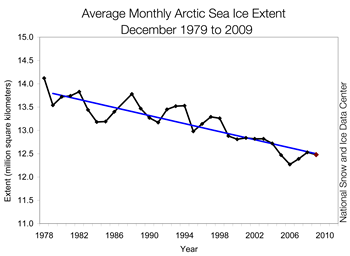
Figure 3. Monthly December ice extent for 1979 to 2009 shows a decline of 3.3% per decade.
Warm air keeps ice extent low
December air temperatures over the Arctic Ocean region, eastern Siberia, and northwestern North America were warmer than normal. In contrast, temperatures in Eurasia, the United States, and southwestern Canada were below average. The strongest anomalies (more than 7 degrees Celsius/13 degrees Fahrenheit) were over the Atlantic side of the Arctic, including Baffin Bay and Davis Strait, where ice extent was below average.
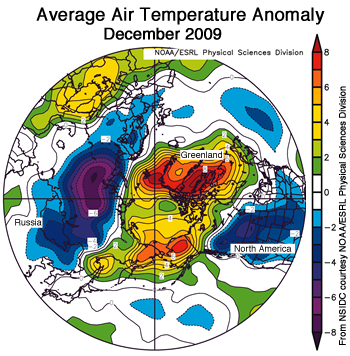
Figure 4. Map of air temperature anomalies for December 2009, at the 925 millibar level (roughly 1,000 meters <3,000 feet> above the surface) for the region north of 30 degrees N, shows warmer than usual temperatures over the Arctic Ocean and cooler than normal temperatures over central Eurasia, the United States and southwestern Canada. Areas in orange and red correspond to strong positive (warm) anomalies. Areas in blue and purple correspond to negative (cool) anomalies.
Negative phase of the Arctic Oscillation
These regional contrasts in temperature anomalies resulted from a strongly negative phase of the Arctic Oscillation (AO). The AO is a natural pattern of climate variability. It consists of opposing patterns of atmospheric pressure between the polar regions and middle latitudes. The positive phase of the AO exists when pressures are lower than normal over the Arctic, and higher than normal in middle latitude. In the negative phase, the opposite is true; pressures are higher than normal over the Arctic and lower than normal in middle latitudes. The negative and positive phases of the AO set up opposing temperature patterns. With the AO in its negative phase this season, the Arctic is warmer than average, while parts of the middle latitudes are colder than normal. The phase of the AO also affects patterns of precipitation, especially over Europe.
The phase of the AO is described in terms of an index value. In December 2009 the AO index value was -3.41, the most negative value since at least 1950, according to data from the NOAA Climate Prediction Center.
While a negative AO leads to warmer temperatures over the Arctic, it also tends to reduce the flow of sea ice out of the Arctic by affecting the winds that can export the ice to warmer waters, where it melts. In this way, a negative AO could help retain some the second- and third-year ice through the winter, and potentially rebuild some of the older, multiyear ice that has been lost over the past few years. However, we do not yet know if the strongly negative AO will persist through the winter, or what its net effect will be.
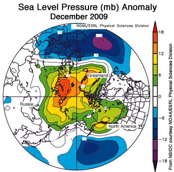
Figure 5. The map of sea level pressure anomalies (in millibars) for December 2009, shows higher than average pressures over Arctic latitudes (areas in orange and red) and lower than average pressures over north Pacific and North Atlantic oceans (areas in blue and purple.
2009 year in review
The minimum ice extent in September 2009 was greater than the past two Septembers, but again fell below the long-term average. The melt season began with a young, thin Arctic sea ice cover, suggesting that significant amounts of ice would be lost during the melt season. However, a cooler summer with favorable winds helped preserve the ice.
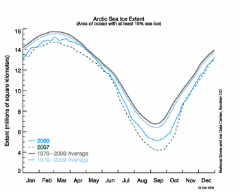
Figure 6. The daily time series for 2009. The gray line shows the 1979 to 2000 climatology, thick blue-gray indicates the 1979 to 2009 climatology, dashed green shows 2007, and 2009 is shown in sky blue.
Despite the cool summer, the ice remained thin and vulnerable at the sea ice minimum, with little of the older, thicker ice that used to characterize much of the Arctic. Recently published research by Barber and colleagues shows that the ice cover was even more fragile at the end of the melt season than satellite data indicated, with regions of the Beaufort and Chukchi Seas covered by small, rotten ice floes.
In the fall, the sea ice froze up in fits and starts. The Northern Sea Route opened in October, even after sea ice extent for the Arctic as a whole had begun to increase. The annual average extent for 2009 was 11.18 million square kilometers (4.32 million square miles), 970,000 square kilometers (375,000 square miles) or 8.0% below 1979 to 2000 average and 740,000 square kilometers (286,000 square miles) or 6.2% below the 1979 to 2008 average.
EDIT/END
http://nsidc.org/arcticseaicenews/index.html