Democratic Underground Latest Greatest Lobby Journals Search Options Help Login
Google

Glaciers on Mt. Shasta keep growing

Printer-friendly format Printer-friendly format
Printer-friendly format Email this thread to a friend
Printer-friendly format Bookmark this thread
This topic is archived.
Home » Discuss » Topic Forums » Environment/Energy Donate to DU
 
depakid Donating Member (1000+ posts) Send PM | Profile | Ignore Wed Jul-09-08 04:58 AM
Original message
Glaciers on Mt. Shasta keep growing


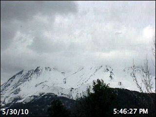
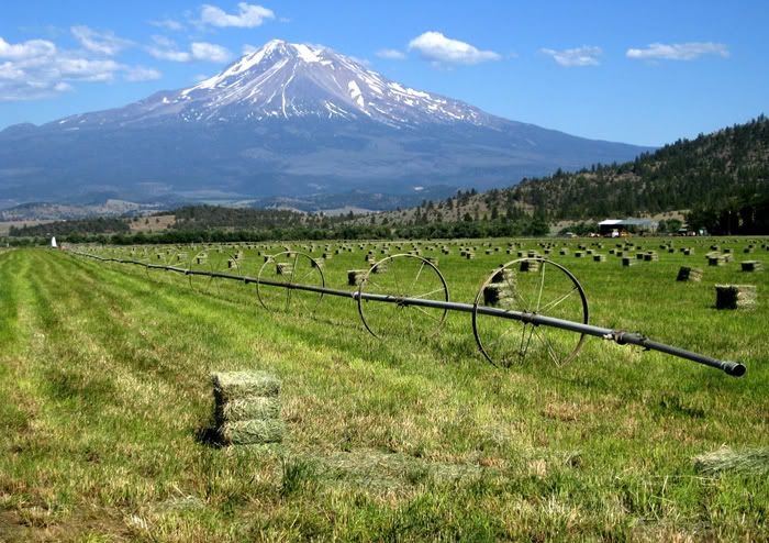
Reaching more than 14,000 feet above sea level, Mt. Shasta dominates the landscape of high plains and conifer forests in far Northern California.

While it’s not California’s tallest mountain, the tongues of ice creeping down Shasta’s volcanic flanks give the solitary mountain another distinction. Its seven glaciers, referred to by American Indians as the footsteps made by the creator when he descended to Earth, are the only historical glaciers in the continental U.S. known to be growing.

With global warming causing the retreat of glaciers in the Sierra Nevada, the Rocky Mountains and elsewhere in the Cascades, Mt. Shasta is actually benefiting from changing weather patterns over the Pacific Ocean.

“When people look at glaciers around the world, the majority of them are shrinking,” said Slawek Tulaczyk, an assistant professor of earth sciences at the University of California, Santa Cruz.

“These glaciers seem to be benefiting from the warming ocean.”

Warmer temperatures have cut the number of glaciers at Montana’s Glacier National Park from 150 to 26 since 1850, and some scientists project there will be none left within 25 to 30 years.

The timeline for the storied snows at Africa’s Mount Kilimanjaro is even shorter, while the ice fields of Patagonia in Argentina and Chile also are retreating.

It’s a different story at Mt. Shasta, the southernmost volcano in the Cascade Range that is about 270 miles north of San Francisco.

Scientists say a warming Pacific Ocean means more moist air sweeping over far Northern California. Because of Shasta’s location and 14,162-foot elevation, the precipitation is falling as snow, adding to the mass of the mountain’s glaciers.

“It’s a bit of an anomaly that they are growing, but it’s not to be unexpected,” said Ed Josberger, a glaciologist at the U.S. Geological Survey in Tacoma, Wash., who is currently studying retreating glaciers in Alaska and the northern Cascades of Washington.

Historical weather records show Mt. Shasta has received 17 percent more precipitation in the last 110 years. The glaciers have soaked up the snowfall and have been adding more snow than is lost through summer melting.

The additional snowfall has been enough to overcome a 1.8 degree Fahrenheit rise in temperature in the last century, according to a 2003 analysis by Tulaczyk, who led a team studying Shasta’s glaciers.

By comparison, the glaciers in the Sierra Nevada, which are about 560 miles south of Mt. Shasta, are exposed to warmer summer temperatures and are retreating.

The Sierra’s 498 ice formations — glaciers and ice fields — have shrunk by about half their size over the past 100 years, with those exposed to direct sunlight shrinking fastest, said Andrew Fountain, a geology professor at Portland State University who has inventoried the glaciers in the continental U.S. as part of a federal initiative.

He said Shasta’s seven glaciers are the only ones scientists have identified as getting larger, with the exception of a small glacier in the shaded crater of Washington state’s Mount St. Helens. It formed after the 1980 eruption blasted away slightly more than half the mountain’s ice, and scientists believe it will not grow in area once it stretches outside the shade of the crater.

More: http://www.pressdemocrat.com/article/20080708/NEWS/17611494/1350&title=Shasta_s_glaciers_keep_growing#
Printer Friendly | Permalink |  | Top
orleans Donating Member (1000+ posts) Send PM | Profile | Ignore Wed Jul-09-08 05:33 AM
Response to Original message
1. interesting. i guess the republikas were right when they said global warming isn't bad.
:sarcasm:
Printer Friendly | Permalink |  | Top
 
Howzit Donating Member (918 posts) Send PM | Profile | Ignore Sat Jul-12-08 05:42 AM
Response to Reply #1
19. Are you suggesting
that all Democrats believe global warming is a problem that can be mitigated by reducing human CO2 emissions; while all Republicans are deniers? If so, doesn't this idea lend credence to the notion that global warming activism is politically rather than scientifically motivated?
Printer Friendly | Permalink |  | Top
 
XemaSab Donating Member (1000+ posts) Send PM | Profile | Ignore Thu Jul-10-08 01:48 PM
Response to Original message
2. The southernmost volcano in the Cascade Range?
Hardly. :eyes:
Printer Friendly | Permalink |  | Top
 
kestrel91316 Donating Member (1000+ posts) Send PM | Profile | Ignore Thu Jul-10-08 03:06 PM
Response to Reply #2
3. Well, Lassen might be considered Northern Sierra rather than Southern Cascades.
Heck, we have an inactive "cinder cone" right next to the highway that goes from LA to Lone Pine on the E side of the Sierras, lol. I always get a little nervous driving past it, with its bare cinder-covered slopes.......
Printer Friendly | Permalink |  | Top
 
XemaSab Donating Member (1000+ posts) Send PM | Profile | Ignore Thu Jul-10-08 03:27 PM
Response to Reply #3
4. Lassen is a volcano
It's in the Cascades.

The Cascades by definition are volcanic.

People down south just get a little confused about the geography up here. ;)
Printer Friendly | Permalink |  | Top
 
XemaSab Donating Member (1000+ posts) Send PM | Profile | Ignore Thu Jul-10-08 04:26 PM
Response to Reply #3
7. Oh, and to go all nerdy on you:
The Cascades are formed by the subduction of the Juan de Fuca plate under the North American plate in the Cascadian subduction zone. This zone stretches from Cape Mendocino to the northern part of Vancouver Island.

Lassen is due east of Cape Mendocino.
Printer Friendly | Permalink |  | Top
 
kestrel91316 Donating Member (1000+ posts) Send PM | Profile | Ignore Fri Jul-11-08 11:30 AM
Response to Reply #7
15. I'd live in the Cascadia Subduction Zone if it WEREN'T
the Cascadia Subduction Zone, lol. They say they could have a 9.0+ quake there someday, and sooner rather than later. Having been at virtually the epicenter of Northridge, I think I'll pass........
Printer Friendly | Permalink |  | Top
 
Ichingcarpenter Donating Member (1000+ posts) Send PM | Profile | Ignore Thu Jul-10-08 04:12 PM
Response to Original message
5. This is a big 'talking' point for anti climate change groups
Expect it to be used as another lame argument by the deniers.
Printer Friendly | Permalink |  | Top
 
Indenturedebtor Donating Member (1000+ posts) Send PM | Profile | Ignore Thu Jul-10-08 05:07 PM
Response to Reply #5
8. Yes and when you point out WHY it's growing
They'll change the subject. Prove them stooooopeeed three times and the insults will start. :eyes:
Printer Friendly | Permalink |  | Top
 
Howzit Donating Member (918 posts) Send PM | Profile | Ignore Fri Jul-11-08 02:00 PM
Response to Reply #8
16. Where can I get info on why its growing? Thanks NT
Printer Friendly | Permalink |  | Top
 
Indenturedebtor Donating Member (1000+ posts) Send PM | Profile | Ignore Fri Jul-11-08 02:45 PM
Response to Reply #16
17. It's in the article above
Basically disruptions to the local climate caused by global warming have increased precipitation on that particular mountain.
Printer Friendly | Permalink |  | Top
 
Howzit Donating Member (918 posts) Send PM | Profile | Ignore Sat Jul-12-08 05:35 AM
Response to Reply #17
18. Thanks
Printer Friendly | Permalink |  | Top
 
XemaSab Donating Member (1000+ posts) Send PM | Profile | Ignore Thu Jul-10-08 04:15 PM
Response to Original message
6. .
Printer Friendly | Permalink |  | Top
 
hatrack Donating Member (1000+ posts) Send PM | Profile | Ignore Thu Jul-10-08 05:09 PM
Response to Reply #6
9. Hey, Xema - that wouldn't be a picture of . . . Mt. Shasta, would it?
:evilgrin:
Printer Friendly | Permalink |  | Top
 
XemaSab Donating Member (1000+ posts) Send PM | Profile | Ignore Thu Jul-10-08 05:33 PM
Response to Reply #9
10. It's one of those mountains
I can't keep them all straight. :shrug:
Printer Friendly | Permalink |  | Top
 
Ichingcarpenter Donating Member (1000+ posts) Send PM | Profile | Ignore Thu Jul-10-08 06:07 PM
Response to Reply #10
11. Looks about right I found another one from today


Notice the article's Picture!!!!!


Printer Friendly | Permalink |  | Top
 
XemaSab Donating Member (1000+ posts) Send PM | Profile | Ignore Thu Jul-10-08 06:10 PM
Response to Reply #11
12. In the interests of honesty and fairness
One's of the south side; the other's of the north side. ;)

But there's no date on the picture of the north side. :P


Printer Friendly | Permalink |  | Top
 
Nihil Donating Member (1000+ posts) Send PM | Profile | Ignore Fri Jul-11-08 03:47 AM
Response to Reply #12
13. Well they certainly look completely different to me ...
... but maybe that's because one is a web-cam and it's 00:50:09 according
to its timestamp ...
:silly:
Printer Friendly | Permalink |  | Top
 
depakid Donating Member (1000+ posts) Send PM | Profile | Ignore Fri Jul-11-08 04:31 AM
Response to Reply #12
14. Mt. Shasta on June 17
Edited on Fri Jul-11-08 05:02 AM by depakid
This one's from above Panther Meadows (Southwest face). Normally, I wouldn't expect it to be open this time of year, but on a whim we went up there, and aside from lingering snowpack in the forests around the campsites, the mountain and the roads were clear:


------------

From around Gazelle (Northwest face)


-----------

The picture posted with the article is from East NorthEast. The smaller peak is called http://volcanoes.usgs.gov/Hazards/Where/ShastaDanger/shastina.html">Shastina, and in addition to 10 glaciers, there are several subaerial lakes up there.

Having seen the mountain at various seasons through the years, it sure has looked to my untrained eyes as though there hasn't been as much snow as there was back in the late 70's and 80's. Back then, I wouldn't even have thought about getting up to panther meadows that early in June, especially in a good snow year.

So the article kind of took me by surprise.
Printer Friendly | Permalink |  | Top
 
DU AdBot (1000+ posts) Click to send private message to this author Click to view 
this author's profile Click to add 
this author to your buddy list Click to add 
this author to your Ignore list Wed May 01st 2024, 07:40 PM
Response to Original message
Advertisements [?]
 Top

Home » Discuss » Topic Forums » Environment/Energy Donate to DU

Powered by DCForum+ Version 1.1 Copyright 1997-2002 DCScripts.com
Software has been extensively modified by the DU administrators


Important Notices: By participating on this discussion board, visitors agree to abide by the rules outlined on our Rules page. Messages posted on the Democratic Underground Discussion Forums are the opinions of the individuals who post them, and do not necessarily represent the opinions of Democratic Underground, LLC.

Home  |  Discussion Forums  |  Journals |  Store  |  Donate

About DU  |  Contact Us  |  Privacy Policy

Got a message for Democratic Underground? Click here to send us a message.

© 2001 - 2011 Democratic Underground, LLC