Democratic Underground Latest Greatest Lobby Journals Search Options Help Login
Google

New Orleans may take another hit this week:

Printer-friendly format Printer-friendly format
Printer-friendly format Email this thread to a friend
Printer-friendly format Bookmark this thread
This topic is archived.
Home » Discuss » Archives » General Discussion (Through 2005) Donate to DU
 
Minstrel Boy Donating Member (1000+ posts) Send PM | Profile | Ignore Mon Sep-05-05 12:26 PM
Original message
New Orleans may take another hit this week:
This Java simulation shows a Tropical Storm in the Gulf projected to hit NO with force of Cat 3 and 4 winds Sept 9:

http://moe.met.fsu.edu/cgi-bin/gfdltc2.cgi?time=2005090500-invest94l&field=Sea+Level+Pressure&hour=Animation

Printer Friendly | Permalink |  | Top
Seeking Serenity Donating Member (1000+ posts) Send PM | Profile | Ignore Mon Sep-05-05 12:30 PM
Response to Original message
1. Can someone interpret that for a dullard like me?
n/t
Printer Friendly | Permalink |  | Top
 
expatriot Donating Member (1000+ posts) Send PM | Profile | Ignore Mon Sep-05-05 12:32 PM
Response to Reply #1
4. it shows a cat 3 storm firing up from almost nothing over Florida and then
rolling west just off the gulf coast and then slamming into the bayou.

i have never seen anything like it, i am also a laymen but i thought the impetus for hurricanes formed off of west africa, not florida.
Printer Friendly | Permalink |  | Top
 
ClintonTyree Donating Member (1000+ posts) Send PM | Profile | Ignore Mon Sep-05-05 01:28 PM
Response to Reply #4
42. Katrina was a tropical storm of Florida's Atlantic coast,,,,,,,,,
it intensified just before landfall in Florida to a CAT 1 Hurricane, after crossing Florida it intensified once again in the 90 degree waters in the Gulf of Mexico. Everything we thought we knew about Hurricanes is being re-written. Global Warming? Nahhhh, flawed science! Right? :shrug:
Printer Friendly | Permalink |  | Top
 
Walt Starr Donating Member (1000+ posts) Send PM | Profile | Ignore Mon Sep-05-05 12:34 PM
Response to Reply #1
6. Tropical Wave off Atlantic Coast is set to become TS Nate
Computer models show it moving across the Florida peninsula and into the Gulf, developing into a CAt 3 or 4 urricane and striking in the same region as Katrina.
Printer Friendly | Permalink |  | Top
 
DoYouEverWonder Donating Member (1000+ posts) Send PM | Profile | Ignore Mon Sep-05-05 12:41 PM
Response to Reply #6
14. Got a link that's in English
I can't figure out the charts that Minstral Boy posted.

Printer Friendly | Permalink |  | Top
 
kdmorris Donating Member (1000+ posts) Send PM | Profile | Ignore Mon Sep-05-05 01:52 PM
Response to Reply #6
47. Actually, it has to beat TD15 now
TD15 just formed out of the 93L (which is a bit to the east of this system and modeled to be a fish).

But, it could be Tropical Storm Ophelia (if it develops).
Printer Friendly | Permalink |  | Top
 
expatriot Donating Member (1000+ posts) Send PM | Profile | Ignore Mon Sep-05-05 12:31 PM
Response to Original message
2. this is someone's idea of a sick joke, right? nt
Printer Friendly | Permalink |  | Top
 
Walt Starr Donating Member (1000+ posts) Send PM | Profile | Ignore Mon Sep-05-05 12:36 PM
Response to Reply #2
11. Nope, the potential is very real. Tropical wave right now
Strong chance for develoment tomorrow. Would becoe Tropical Storm Nate by Wednesday, Hurricane Nate on Thursday.
Printer Friendly | Permalink |  | Top
 
Webster Green Donating Member (1000+ posts) Send PM | Profile | Ignore Mon Sep-05-05 12:42 PM
Response to Reply #2
17. Yeah, God's isea of a sick joke...
The dude (or dudess) is a real sicko!


Demand resignations! Now!


Printer Friendly | Permalink |  | Top
 
RebelOne Donating Member (1000+ posts) Send PM | Profile | Ignore Mon Sep-05-05 01:17 PM
Response to Reply #17
36. Not god. Mother Nature. n/t
Printer Friendly | Permalink |  | Top
 
MojoXN Donating Member (1000+ posts) Send PM | Profile | Ignore Mon Sep-05-05 12:32 PM
Response to Original message
3. Oh, dear sweet Jesus, I hope not.
This is just one nightmare after another...

MojoXN
Printer Friendly | Permalink |  | Top
 
applegrove Donating Member (1000+ posts) Send PM | Profile | Ignore Mon Sep-05-05 12:33 PM
Response to Original message
5. Oh - great. Now that there is debris everywhere..it will be a blender.
Printer Friendly | Permalink |  | Top
 
libertypirate Donating Member (1000+ posts) Send PM | Profile | Ignore Mon Sep-05-05 12:35 PM
Response to Original message
7. Since it kind of like predicting a slot machine, I would say it is a bit
early....

http://www.nrlmry.navy.mil/tc_pages/tc_home.html

They are not even named storms as of yet, storm menu on left side.
Printer Friendly | Permalink |  | Top
 
Rainscents Donating Member (1000+ posts) Send PM | Profile | Ignore Mon Sep-05-05 12:46 PM
Response to Reply #7
20. Maybe they'll name the next storm... King George.
Printer Friendly | Permalink |  | Top
 
Tyranny_R_US Donating Member (988 posts) Send PM | Profile | Ignore Mon Sep-05-05 12:35 PM
Response to Original message
8. Now maybe FEMA can get a little taste :)
Printer Friendly | Permalink |  | Top
 
Catherine Vincent Donating Member (1000+ posts) Send PM | Profile | Ignore Mon Sep-05-05 12:35 PM
Response to Original message
9. Oh my!
Printer Friendly | Permalink |  | Top
 
benburch Donating Member (1000+ posts) Send PM | Profile | Ignore Mon Sep-05-05 12:36 PM
Response to Original message
10. That prediction is a real stretch.
I seriously doubt this will come to pass, but I'll keep an eye on it.

The reason is that it spends too much of its time over land or nearshore, and that usually keeps tropical cyclones from maintaining themselves.
Printer Friendly | Permalink |  | Top
 
ClintonTyree Donating Member (1000+ posts) Send PM | Profile | Ignore Mon Sep-05-05 01:32 PM
Response to Reply #10
43. Study the history of Katrina......
from the time it was a tropical storm off the Atlantic coast of Florida. No one could have guessed at that time what the final outcome would be. The initial forecast was for it to follow Florida's Gulf Coast northward as a tropical depression. The rest, as they say, is history.
Printer Friendly | Permalink |  | Top
 
MadeinOhio Donating Member (1000+ posts) Send PM | Profile | Ignore Mon Sep-05-05 12:38 PM
Response to Original message
12. I don't think this is a real stretch at all.....
I think we need Bush to resign right AWAY and get justice served very quickly because it ain't over yet and our mistakes of global warming are coming.......
Printer Friendly | Permalink |  | Top
 
benburch Donating Member (1000+ posts) Send PM | Profile | Ignore Mon Sep-05-05 12:50 PM
Response to Reply #12
26. I certainly don't think THAT is a stretch at all.
Whether this awful oracle comes to pass or not, more storms are coming, and they will come almost every year and in larger and larger numbers and more intensity. Eventually, we may even see a "hypercane" that destroys much of the southern USA. All the fruits of excessive CO2 emissions and the lack of leadership from the one nation that produces more CO2 per capita than any other.
Printer Friendly | Permalink |  | Top
 
undeterred Donating Member (1000+ posts) Send PM | Profile | Ignore Mon Sep-05-05 12:55 PM
Response to Reply #12
31. Maybe we can get him to go down there for a photo op
and meet Nate in person. :evilgrin:
Printer Friendly | Permalink |  | Top
 
Fleshdancer Donating Member (1000+ posts) Send PM | Profile | Ignore Mon Sep-05-05 12:38 PM
Response to Original message
13. we must move the survivors and gather our dead as soon as possible
Edited on Mon Sep-05-05 12:38 PM by GloriaSmith
of course we should be doing this with or without the possibility of another storm hitting but the idea of people still in there when another storm hits is horrific.
Printer Friendly | Permalink |  | Top
 
MazeRat7 Donating Member (1000+ posts) Send PM | Profile | Ignore Mon Sep-05-05 12:41 PM
Response to Original message
15. Looks llike the TD is already formed off east fla (see 00Z05SEP) tag
Edited on Mon Sep-05-05 12:43 PM by MazeRat7
Sure hope this plays out different. If not, this one will rake the entire gulf seaboard. Bad would be an understatement.

Here is a link to the FLA weather radar
http://www.wunderground.com/radar/radblast.asp?zoommode=zoom&ID=AMX&type=N0R&frame=0&lat=25.82897949&lon=-80.28563690&label=Miami%2C+FL&num=1&showstorms=0&scale=1.000¢erx=400¢ery=240&showlabels=1&map.x=427&map.y=110

Now look at the start of the simulation. Pretty damn close in my non-professional opinion.

MZr7
Printer Friendly | Permalink |  | Top
 
sakabatou Donating Member (1000+ posts) Send PM | Profile | Ignore Mon Sep-05-05 12:42 PM
Response to Original message
16. Eep
Edited on Mon Sep-05-05 12:42 PM by sakabatou
:tinfoilhat:
Printer Friendly | Permalink |  | Top
 
rzemanfl Donating Member (1000+ posts) Send PM | Profile | Ignore Mon Sep-05-05 12:43 PM
Response to Original message
18. National Hurricane Center has nothing on this. Can you get
further info? I am right in the projected path and scheduled to fly out of Tampa on Thursday.
Printer Friendly | Permalink |  | Top
 
DoYouEverWonder Donating Member (1000+ posts) Send PM | Profile | Ignore Mon Sep-05-05 12:49 PM
Response to Reply #18
23. I don't think we have a problem
It's real windy up by me today but that isn't unusual in the fall. No rain or anything except the usual.

I don't think it will build into anything by starting along the east coast and going across FL, except for a windy day. No water for it to build into anything. If it organizes on the other side in the gulf then it will be worth watching.

Plus this system is very cool, at least here so again I don't think it will stay together to become a hurricane.


Printer Friendly | Permalink |  | Top
 
rzemanfl Donating Member (1000+ posts) Send PM | Profile | Ignore Mon Sep-05-05 12:57 PM
Response to Reply #23
32. Unusually breezy here today too Dunedin on Gulf Coast North
of Clearwater. Where are you?
Printer Friendly | Permalink |  | Top
 
DoYouEverWonder Donating Member (1000+ posts) Send PM | Profile | Ignore Mon Sep-05-05 01:53 PM
Response to Reply #32
48. Gainesville
It's the first day that feels like fall, at least for No FL standards.

Printer Friendly | Permalink |  | Top
 
Loge23 Donating Member (1000+ posts) Send PM | Profile | Ignore Mon Sep-05-05 01:21 PM
Response to Reply #18
40. area of low pressure
out west of the Bahamas. Still unsettled but worth watching.
Another large mass is just east of the Bahamas
Printer Friendly | Permalink |  | Top
 
kdmorris Donating Member (1000+ posts) Send PM | Profile | Ignore Mon Sep-05-05 01:56 PM
Response to Reply #18
50. All NHC really has is
The Tropical Weather Outlook and the Tropical Weather Discussion. The link are here:

TWO: http://www.nhc.noaa.gov/text/refresh/MIATWOAT+shtml/051500.shtml

TWD: http://www.nhc.noaa.gov/text/refresh/MIATWDAT+shtml/051735.shtml?

Printer Friendly | Permalink |  | Top
 
teach1st Donating Member (1000+ posts) Send PM | Profile | Ignore Mon Sep-05-05 12:44 PM
Response to Original message
19. Jeff Masters sees it differently
http://www.wunderground.com/blog/JeffMasters/show.html

Two disturbances to watch off of the coast of Florida.

The important threat in the tropics today is a large area of disturbed weather extending from Miami eastward over the Bahama Islands. A small circulation center, visible on winds from the QuikSCAT satellite, has developed in association with this disturbance, about 50 miles east of Ft. Lauderdale, FL. Shear values are still probably a little too high--about 10 knots--to permit a tropical depression to form in this region today. However, the shear is forecast to decrease, and a tropical depression could form Tuesday or Wednesday. The computer models are less agressive developing this system today, but still indicate a tropical storm could form here and very slowly move northwards along the coast of Florida towards the Carolinas.

A second disturbance with a well-defined circulation visible on both visible satellite images and QuikSCAT data is located about 600 miles east of Cape Canaveral, Florida. A concentrated area of deep convection has developed on the south and east sides of the circulation center. There is no convection over the center, which would have to happen before the system can be classified as tropical depression. Highest winds observed by the QuikSCAT satellite are about 20 knots. Shear values are about 10 knots, which is marginal for development, but the shear is likely to decrease some today and tomorrow, and this system has a good chance of becoming Tropical Depression 15. The system is expected to move slowly northwestward and meander in the area between Bermuda and the Carolinas.
Printer Friendly | Permalink |  | Top
 
MadeinOhio Donating Member (1000+ posts) Send PM | Profile | Ignore Mon Sep-05-05 12:47 PM
Response to Reply #19
21. If this is true.......With the Gulf waters so hot now...
This bastard could be hitting both the Gulf and North/South Carolina!

:grr:
Printer Friendly | Permalink |  | Top
 
Individualist Donating Member (1000+ posts) Send PM | Profile | Ignore Mon Sep-05-05 12:50 PM
Response to Reply #19
25. So does NOAA
Tropical advisory gives information about the Pacific, and says elsewhere...no formation of tropical storms is expected through Tuesday.

www.nhc.noaa.gov/text/refresh/MIATWOEP+shtml/051611.shtml
Printer Friendly | Permalink |  | Top
 
Rainscents Donating Member (1000+ posts) Send PM | Profile | Ignore Mon Sep-05-05 12:51 PM
Response to Reply #19
27. Well, you know what, they didn't predicted Katrina to hit Gulf of NO
Edited on Mon Sep-05-05 12:54 PM by Rainscents
at first, storm took many by surprised "every" weather people!
Printer Friendly | Permalink |  | Top
 
DoYouEverWonder Donating Member (1000+ posts) Send PM | Profile | Ignore Mon Sep-05-05 01:21 PM
Response to Reply #27
39. They knew before Katrina hit FL
that she was going to go across FL and reform in the Gulf and get stronger.

This was predicted before Katrina turned into a hurricane.


Printer Friendly | Permalink |  | Top
 
ClintonTyree Donating Member (1000+ posts) Send PM | Profile | Ignore Mon Sep-05-05 01:41 PM
Response to Reply #39
45. It's first predicted track....
was up the Gulf Coast of Florida into the big bend area. Katrina fooled them all. A Hurricane NEVER tracks from the northeast to the southwest, right? Not in recent history anyway. I follow these things like a hawk from when they first leave Africa. I've been doing this for four years now, ever since my daughter started at Tulane University. We've had to evacuate her 4 times in four years. She was to return to NOLA on the 27th of August. I wouldn't let her.
Katrina defied all conventional wisdom concerning Hurricanes. One fickle and deadly lady she was.
Printer Friendly | Permalink |  | Top
 
DoYouEverWonder Donating Member (1000+ posts) Send PM | Profile | Ignore Mon Sep-05-05 01:54 PM
Response to Reply #45
49. Katrina certainly was deadly
but certainly wasn't fickle once she formed off the coast of FL

Printer Friendly | Permalink |  | Top
 
Dogmudgeon Donating Member (1000+ posts) Send PM | Profile | Ignore Mon Sep-05-05 03:32 PM
Response to Reply #45
55. Is your daughter all right?
:yoiks:

--p!
Printer Friendly | Permalink |  | Top
 
soup Donating Member (1000+ posts) Send PM | Profile | Ignore Mon Sep-05-05 01:15 PM
Response to Reply #19
35. Projection all over the place.
Trying to find the graphic. WAY too early to sound any alarms along the Gulf coast.

here it is:

discussion:
http://flhurricane.com/

graphic:
http://www.skeetobiteweather.com/imagelinkbeta.asp?image=AL932005
Printer Friendly | Permalink |  | Top
 
rzemanfl Donating Member (1000+ posts) Send PM | Profile | Ignore Mon Sep-05-05 01:26 PM
Response to Reply #35
41. I think there are two different possible storms being discussed
here. One off of Ft. Lauderdale and the other much further out.
Printer Friendly | Permalink |  | Top
 
soup Donating Member (1000+ posts) Send PM | Profile | Ignore Mon Sep-05-05 01:40 PM
Response to Reply #41
44. Yes, that's why I only posted the one by the Bahamas(94).
Here's the spagetti projection for the other that's further off the coast(93):
http://www.skeetobiteweather.com/imagelinkbeta.asp?image=AL932005

and the discussion:
NHC is now monitoring a new area of interest (Invest 93L) to the east of the central Bahamas - see the Storm Forum for initial info on this disturbed area. A weak surface low was located near 26.5N 66.5W at 04/12Z with convection primarily south of the low. The low was drifting slowly to the north and slow development of this system is possible. Models generally take the system north and then northeast .
http://flhurricane.com/

--

But, then there's 92L, too. *sigh

Invest 92L was showing new signs of increased convection near 10N 52W at 04/12Z. The system is moving west northwest into an area that is more favorable for development and this could become a Tropical Depression in the next day or two. Models intensify this system and move it into the central Caribbean Sea south of the Dominican Republic by mid-week - worth keeping a close eye on this one.
http://flhurricane.com/

--

Finding nothing that says New Orleans is definitely going to get hit again.
Printer Friendly | Permalink |  | Top
 
KoKo Donating Member (1000+ posts) Send PM | Profile | Ignore Mon Sep-05-05 01:19 PM
Response to Reply #19
37. The Weather Channel just verified Masters forecasts...they are watching
the disturbance that's hovering near Ft. Lauderdale...

Sounds more like it will be a problem for us in the Carolinas than those in the Gulf, if it develops. :scared:
Printer Friendly | Permalink |  | Top
 
wake.up.america Donating Member (1000+ posts) Send PM | Profile | Ignore Mon Sep-05-05 12:48 PM
Response to Original message
22. Can we arrange a photo op or press conference about the same time it hits?
Edited on Mon Sep-05-05 12:49 PM by wake.up.america
Printer Friendly | Permalink |  | Top
 
Minstrel Boy Donating Member (1000+ posts) Send PM | Profile | Ignore Mon Sep-05-05 12:49 PM
Response to Original message
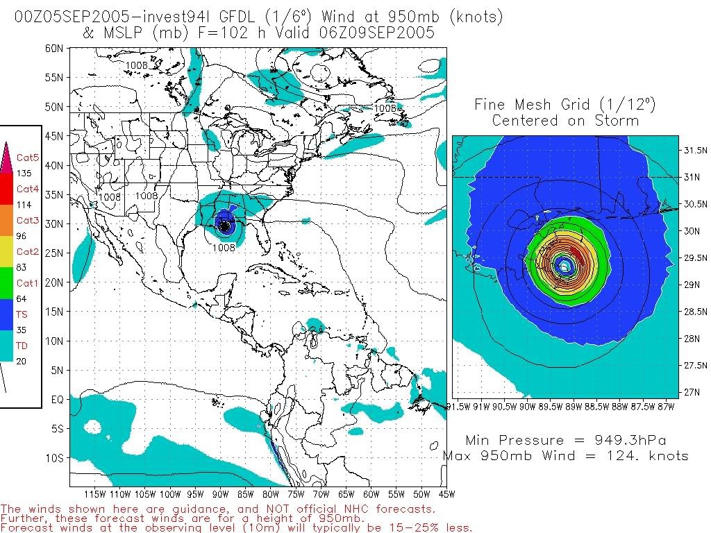
24. screen capture of projected Sept 9 landfall:
Printer Friendly | Permalink |  | Top
 
DoYouEverWonder Donating Member (1000+ posts) Send PM | Profile | Ignore Mon Sep-05-05 12:51 PM
Response to Reply #24
28. Got a NOAA link?
Photobucket ain't gonna do it.

Printer Friendly | Permalink |  | Top
 
kdmorris Donating Member (1000+ posts) Send PM | Profile | Ignore Mon Sep-05-05 01:46 PM
Response to Reply #28
46. Actually, this is a model run
Edited on Mon Sep-05-05 01:49 PM by kdmorris
of the GFDL, which is a pretty good model. In fact, the GFDL is the only model that had Katrina going SW over the FL penisula. This particular storm is currently called Invest 94L, so you should be able to find information and models about it. If it forms before 93L (which just became TD 15) it will be Tropical Storm Nate. Otherwise, this one would be Opehilia (Dang, another pretty name!)

Edited to add the link:

http://www.nhc.noaa.gov/text/refresh/MIATWOAT+shtml/051500.shtml

This is a TWO (Tropical Weather Outlook). The part that talks about his systems states:

A BROAD AREA OF LOW PRESSURE HAS REMAINED NEARLY STATIONARY JUST
OFF THE SOUTHEASTERN COAST OF FLORIDA AND OVER THE NORTHWESTERN
BAHAMAS. THIS SYSTEM HAS BECOME SLIGHTLY BETTER ORGANIZED THIS
MORNING...AND A TROPICAL DEPRESSION COULD FORM IN THIS AREA DURING
THE NEXT DAY OR TWO. A NOAA HURRICANE HUNTER AIRCRAFT IS SCHEDULED
TO INVESTIGATE THE SYSTEM TOMORROW..IF NECESSARY. INTERESTS IN THE
BAHAMAS AND FLORIDA SHOULD MONITOR THE PROGRESS OF THIS SYSTEM.
Printer Friendly | Permalink |  | Top
 
Dogmudgeon Donating Member (1000+ posts) Send PM | Profile | Ignore Mon Sep-05-05 12:52 PM
Response to Original message
29. Yes and No
No, New Orleans won't take another hit: Of the seven or eight best-established models, only three show even glancing blows, and none of the models are even close to being "accurate" a week out.

Yes, New Orleans is in for more rough weather: Prevailing winds increase the chance of any tropical system being steered into the Gulf Coast.

But, New Orleans isn't the only part of the Gulf Coast that got hit with Katrina. If a storm veers to the east and misses N.O., it could still ravage Biloxi or Pensacola.

Even a brush-by with heavy rain and moderately brisk winds will cause trouble. The entire levee system is weak, so new breaks are possible. A lot of partially-collapsed buildings could be pushed to complete collapse, posing greater danger to survivors and rescuers. If disease had gained a foothold, more rain could distribute it.

Another direct hit, even with a minimal (Cat-1) hurricane would be a major blow. A second Cat-4, as the GFDL run suggests, would be absolutely catastrophic, even with most of the inhabitants gone.

A strong Cat-5, on the order of Camille (1969) is unthinkable. But so was Katrina just ten days ago.

How many of us are confident that George Bush's FEMA can get its act together in less than two weeks?

--p!
Printer Friendly | Permalink |  | Top
 
electron_blue Donating Member (1000+ posts) Send PM | Profile | Ignore Mon Sep-05-05 12:53 PM
Response to Original message
30. Let's take advantage of Bush being so clueless
Edited on Mon Sep-05-05 12:53 PM by electron_blue
Can anyone here arrange for another Bush photo-op in the N.O. area to occur on, say, Sep 9?
Printer Friendly | Permalink |  | Top
 
MoonRiver Donating Member (1000+ posts) Send PM | Profile | Ignore Mon Sep-05-05 01:03 PM
Response to Original message
33. I'd rather have it hit NO again than somewhere else cause,
nobody's there.
Printer Friendly | Permalink |  | Top
 
benburch Donating Member (1000+ posts) Send PM | Profile | Ignore Mon Sep-05-05 01:12 PM
Response to Reply #33
34. I wish nobody were there...
Edited on Mon Sep-05-05 01:12 PM by benburch
But all indications are that there are still living people trapped.
Printer Friendly | Permalink |  | Top
 
jus_the_facts Donating Member (1000+ posts) Send PM | Profile | Ignore Mon Sep-05-05 01:19 PM
Response to Reply #34
38. as the sayin' says...wish in one hand...and shit in the other...see....
Printer Friendly | Permalink |  | Top
 
Citizen Jane Donating Member (513 posts) Send PM | Profile | Ignore Mon Sep-05-05 01:56 PM
Response to Original message
51. nhc discussion here
Printer Friendly | Permalink |  | Top
 
sexybomber Donating Member (1000+ posts) Send PM | Profile | Ignore Mon Sep-05-05 02:04 PM
Response to Original message
52. I see nothing.
Edited on Mon Sep-05-05 02:08 PM by sexybomber
Granted, Station NMG New Orleans is offline, and they provide the tropical forecast for NOAA...

On edit: That 1008 mB low off Florida could be nasty, though.
Printer Friendly | Permalink |  | Top
 
kansasblue Donating Member (1000+ posts) Send PM | Profile | Ignore Mon Sep-05-05 03:23 PM
Response to Original message
53. .
Edited on Mon Sep-05-05 03:26 PM by kansasblue
Printer Friendly | Permalink |  | Top
 
Minstrel Boy Donating Member (1000+ posts) Send PM | Profile | Ignore Mon Sep-05-05 03:25 PM
Response to Reply #53
54. See post #46:
"This is a model run of the GFDL, which is a pretty good model. In fact, the GFDL is the only model that had Katrina going SW over the FL penisula."
Printer Friendly | Permalink |  | Top
 
DU AdBot (1000+ posts) Click to send private message to this author Click to view 
this author's profile Click to add 
this author to your buddy list Click to add 
this author to your Ignore list Fri May 03rd 2024, 02:51 PM
Response to Original message
Advertisements [?]
 Top

Home » Discuss » Archives » General Discussion (Through 2005) Donate to DU

Powered by DCForum+ Version 1.1 Copyright 1997-2002 DCScripts.com
Software has been extensively modified by the DU administrators


Important Notices: By participating on this discussion board, visitors agree to abide by the rules outlined on our Rules page. Messages posted on the Democratic Underground Discussion Forums are the opinions of the individuals who post them, and do not necessarily represent the opinions of Democratic Underground, LLC.

Home  |  Discussion Forums  |  Journals |  Store  |  Donate

About DU  |  Contact Us  |  Privacy Policy

Got a message for Democratic Underground? Click here to send us a message.

© 2001 - 2011 Democratic Underground, LLC