General Discussion
Related: Editorials & Other Articles, Issue Forums, Alliance Forums, Region ForumsDK x-post: Keystone East: Doubling down? Or admitting KXL defeat?
Do not mistake the Tar Sands Partners for political neophytes, they are politically savvy and from all appearances are planning for all contingencies. They are conducting a 3 front campaign to deliver tar sands oil to the Pacific, the Atlantic, and to the Gulf coast. From there supertankers will take to oil to markets in Western Europe and Asia. Remember that at $10 a gallon, a worker is Asia can afford to spend $20 to fill the tank of a scooter to drive to work for the week. Our suburban sprawl makes that impossible for many Americans.
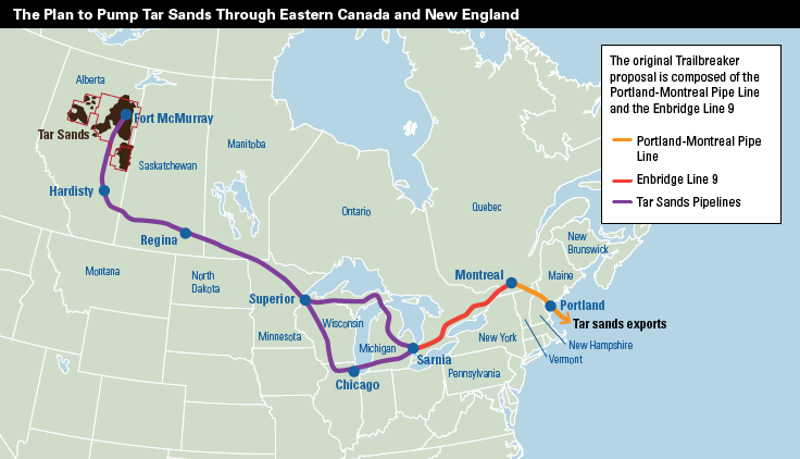
The Keystone XL proposal heads south to the Gulf of Mexico, the Western routes to the Pacific are the Trans Mountain and Enbridge proposals, and the proposed route from Alberta to Portland Maine. Formerly called the Trailbreaker, a pipeline proposal dating from 2009, was put on hold due to the economic downturn. Now Enbridge has resurrected the Trailbreaker proposal and in November of 2012 Enbridge filed the Applications to reverse the flow on the line 9B pipeline, and an expansion of line 9. The 9B and B pipelines may be the most limiting factor with a limit of 150k to 200k bpd. The Portland Montreal pipeline was opened in 1941 and has a 600k bpd capacity. Not exactly Keystone East, but the system is old and should be considered a short term solution.
![]()
Meanwhile the title of Keystone East should go to this proposal, the 850k bpd Energy East pipeline. Sunny Freeman at HuffPo covered this proposal just 2 weeks ago. The Energy East would move tar sands oil from Alberta to the coast of New Brunswick, Canada. Using an existing natural gas pipeline that must be converted to oil, existing oil pipelines and building new pipelines to connect all the pieces, Energy East would be able to deliver 850,000 barrels a day to a New Brunswick port on the Atlantic. Before we explore the Why? Lets explore some background.
Powering the Tar Sands
Among the myriad pipeline proposals are the natural gas pipelines needed to power the Tar Sands extraction. In September 2011, I wrote about the quantities of nat gas required over the life of the Tar Sands project, it roughly equals the known conventional reserves of Canada and Alaska.
Now realistically these numbers I am throwing out are back of the envelope, and recovery techniques will undoubtedly improve over time. But even the Wiki article on the Tar Sands suggests that Canada would limit or halt nat gas exports to the US in favor of tar sands production.
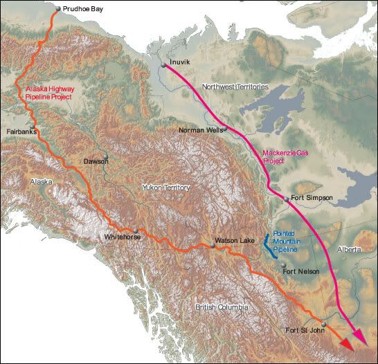
Alaskan nat gas is largely unexploited, and is used locally on the North Slope. Its estimated that there are 57 trillion cubic feet of nat gas reserves that can be found in Alaska, a lot of it in the North Slope area. There are at least 3 major proposals for nat gas pipelines from the North Slope area and the adjacent Mackenzie River Delta in Canada. Two of these projects point right at Alberta.
1) The Mackenzie Valley Pipeline has had many lives since first proposed in the 1970's and would move nat gas from offshore production in the Beaufort Sea to Alberta. In the map on the left, the Mackenzie River route is in purple, and the Alaskan route is in orange.
2) TransCanada and Exxon Mobil are partnered in the Alaska gas pipeline proposal that will directly link nat gas production in the North Slope of ALaska thru Alberta to the US mid west. This project may be the same as the Denali proposal, and was reintroduced to the Senate in Feb, of 2011. There also at least 2 variations.
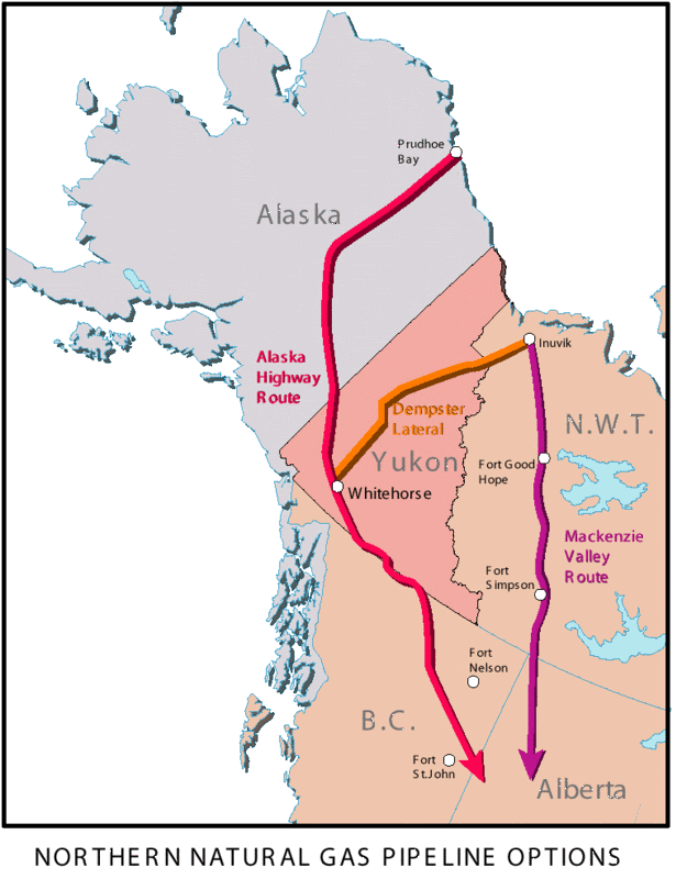
The map above shows the how the Dempster Lateral route connects the Mackenzie and Alaskan routes.
Two options to the "Alaskan Route". Getting nat gas to a seaside terminal opens the possibility of shipping LNG to international customers.
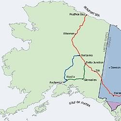
3) A project that follows the TAP, Trans Alaskan Pipeline,putting a nat gas pipeline next to the Alaskan oil pipeline, from Prudhoe Bay to Valdez. This project would allow Alaskan nat gas to be moved to international markets, by-passing the Tar Sands project. See map below:
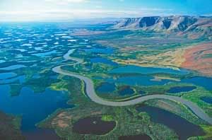
Aerial view of the Mackenzie River Delta, showing off the natural pristine beauty of the area.
Getting Tar Sands oil to the Pacific:
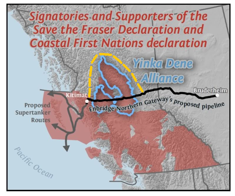
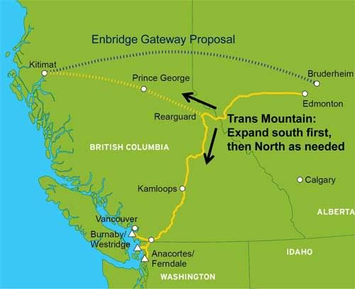
Its now clear the Enbridge pipeline proposal is not going thru Yinka Dene land, that idea is DOA. A reroute around the Yinka Dene land may be forthcoming, but the additional length would add significant cost . A reroute to the north doesn't seem practical (See map to right, yellow dashed line), and I have found no indication that Enbridge is considering this route. What Enbridge does appear to be looking at, is bypassing the Yinka Dene Alliance lands with a southern route that utilizes the oldest Tar Sands pipeline opened in 1953, the Trans Mountain/Morgan Kinder. This pipeline is in the process of being doubled up, this would add an additional 500k BPD to the existing 300k BPD capacity that is delivered to Burnaby near Vancouver. The plan is to branch off the Morgan Kinder and head north to Kittimat. While this route avoids the Yinka Dene lands, it goes thru the First Nations lands, and for more than a few years has met great resistance. If the Tar Sands Partners fail to add west bound pipeline capacity, this greatly hampers their ability to get oil to the Asian markets in any significant quantity.
The 3 Front Battle:
Hundreds of years ago Generals thought of their opponents forces as the left flank, the center, and the right flank. The Tar Sands campaign holds similar to this tenet, they have a western flank, a center, and an eastern flank.
The Tar Sands Partners have met great resistance in the west and more recently have faced increasing pressure in their center, they now have dusted off the Portland proposal and appear to be maneuvering to the east. Throw in Energy East: Are they yielding the western front, or even the Central front? And retreating to the east to regroup? Lets examine some conjecture and see what scenarios that develop.
1) The Tar Sands Partners know KXL & western routes are in trouble.
Rail car and barge transport are only temporary reprieves, we must have more pipeline capacity or shut down further expansion of production. We know that the KXL and western routes are DOA and we have to revive the Trailbreaker proposal and the Energy East proposal to compensate for the loss of KXL and the western routes.
2) The Western routes are in trouble.
We need to buy time to work out issues with those Indians, bribe a politician or an Indian. In the mean time lets dazzle them with our footwork and dust off the old Trailbreaker proposal. This will relieve pressure on the KXL. And we will distract them even further with the Energy East route.
3) We know KXL will be approved: Time to double down.
KXL gives us 900kbpd of pipeline capacity, the western routes can give us a 1.4 million bpd of capacity, and the Portland route adds 200k bpd, while Energy East pipeline will add 850k bpd. All told thats 3.45 million barrels a day of oil we can sell to International markets via these pipelines.
The apparent stalemate on the western routes suggests that this is a stalled front. When considering the newer eastern proposals, they appear to be a reaction to pressure on the western routes and the KXL. As to how this all plays out, we shall see. The Tar Sands are land locked, if the Tar Sands Partners want to export the majority of the proposed 8 million bpd of tar sands production, then their goal will be to build 8 million bpd of pipeline capacity. So far they have only shown us half the cards in their hand. Game on.
http://www.dailykos.com/story/2013/04/18/1195156/-Keystone-East-Doubling-down-Or-admitting-KXL-defeat
 = new reply since forum marked as read
Highlight:
NoneDon't highlight anything
5 newestHighlight 5 most recent replies
= new reply since forum marked as read
Highlight:
NoneDon't highlight anything
5 newestHighlight 5 most recent replies

FogerRox
(13,211 posts)FogerRox
(13,211 posts)Electric Monk
(13,869 posts)straight east to Churchill, Manitoba, which is a port city on Hudson's Bay. I think that'd even be downhill most of the way from Alberta.

FogerRox
(13,211 posts)navigable
Electric Monk
(13,869 posts)In this computer model based off satellite data, Hudson Bay is on the west and the Bering Strait is the top center, then it all rotates counter clockwise a bit.
Here's another one, this is from NASA, with a more conventional orientation.
http://www.juancole.com/2013/04/arctic-summer-years.html
Response to Electric Monk (Reply #3)
cali This message was self-deleted by its author.

grntuscarora
(1,249 posts)But what keeps catching my eye is that corner of Vermont (the Northeast Kingdom) that the Portland-Montreal route crosses. If they're having trouble moving their crap in the west, and think they'll just breeze through Vermont instead, all I can say is---they ain't seen nothin' yet. I don't think they'll find a solution there, not even a short term one.
cali
(114,904 posts)The District 7 Environmental Commission in the Northeast Kingdom, where the existing pipeline they'd use for tar sands oil, ruled that any such change would be subject to Vermont's Act 250 which is a huge bugaboo for polluters and developers and has been for several decades. I have no doubt that Vermont government would fight piping tar sand oil to the bitter end- to say nothing of Vermonters who have already weighed in via town meeting as being adamantly against it.
http://vtdigger.org/2013/04/15/act-250-coordinator-tar-sands-requires-vermont-permit/
grntuscarora
(1,249 posts)nt
FogerRox
(13,211 posts)FogerRox
(13,211 posts)otherwise it'll be too long.
cali
(114,904 posts)
FogerRox
(13,211 posts)
limpyhobbler
(8,244 posts)Much appreciated so we can have more facts when we talk about tar sands and pipelines.
FogerRox
(13,211 posts)
hatrack
(59,583 posts)